The River Parrett flows through the counties of Dorset and Somerset in South West England, from its source in the Thorney Mills springs in the hills around Chedington in Dorset. Flowing northwest through Somerset and the Somerset Levels to its mouth at Burnham-on-Sea, into the Bridgwater Bay nature reserve on the Bristol Channel, the Parrett and its tributaries drain an area of 660 square miles (1,700 km2) – about 50 per cent of Somerset's land area, with a population of 300,000.

Ilchester is a village and civil parish, situated on the River Yeo or Ivel, five miles north of Yeovil, in the English county of Somerset. Originally a Roman town, and later a market town, Ilchester has a rich medieval history and was a notable settlement in the county; around the 12th and 13th centuries it was effectively the county town. It had, however, declined in size and importance by the beginning of the 18th century, and the last markets were held in 1833. In 1889 the historic corporation that had governed the town was dissolved.
Babcary is a village and parish in Somerset, England, situated 5 miles (8.0 km) east of Somerton and 6 miles (9.7 km) south west of Castle Cary in the South Somerset district. The village has a population of 248. It lies close to the River Cary and the A37.

Barrington is a village and civil parish, situated 10 miles (16.1 km) south east of Taunton and 10 miles (16.1 km) west of Yeovil in the South Somerset district of Somerset, England. The village has a population of 438.
Charlton Mackrell is a village in civil parish of The Charltons, in the county of Somerset, England, situated three miles east of Somerton in the South Somerset district. The village has a population of 1,020.

Compton Dundon is a village and civil parish in Somerset, England, situated beside King's Sedge Moor and the Polden Hills, 5 miles (8 km) south of Glastonbury and 4 miles (6 km) north of Somerton in the South Somerset district. The village has a population of 705. The parish includes the hamlet of Littleton.

High Ham is a village and civil parish in Somerset, England. Within the parish of High Ham are the villages of High Ham and Low Ham and the hamlets of Bowdens, Henley, Paradise and Picts Hill.

Huish Episcopi is a village and civil parish in Somerset, England, situated on the outskirts of Langport, 4 miles (6.4 km) south west of Somerton in the South Somerset district. The parish has a population of 2,095, and includes the hamlets of Bowdens, Combe, Pibsbury and Wearne.

Kingweston is a village and civil parish in Somerset, England, situated on top of Combe Hill, 3 miles (4.8 km) north east of Somerton in the South Somerset district. The village has a population of 128.

The Warehouse in Great Bow Yard Langport, Somerset, England is an example of Victorian industrial architecture.

Muchelney is a clustered village and civil parish in Somerset, England, extending for 3 kilometres (1.9 mi) from the south bank of the River Parrett and that has a clustered centre. This is 1 mile (1.6 km) south of Huish and Langport and 4 miles (6.4 km) south west of Somerton in the South Somerset district. Its elevations range from 8 to 12 metres AOD. Muchelney has some orchards and a copse of remaining woodland in the centre-south covering between 2 and 5% of the land.

Pitney is a village and parish in Somerset, England, located 2.5 miles (4.0 km) east of Langport and 3 miles (4.8 km) west of Somerton in the South Somerset district. In 2011, the village had a population of 374.

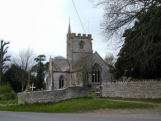
The Grade I listed buildings in Somerset, England, demonstrate the history and diversity of its architecture. The ceremonial county of Somerset consists of a non-metropolitan county, administered by Somerset County Council, which is divided into five districts, and two unitary authorities. The districts of Somerset are West Somerset, South Somerset, Taunton Deane, Mendip and Sedgemoor. The two administratively independent unitary authorities, which were established on 1 April 1996 following the breakup of the county of Avon, are North Somerset and Bath and North East Somerset. These unitary authorities include areas that were once part of Somerset before the creation of Avon in 1974.
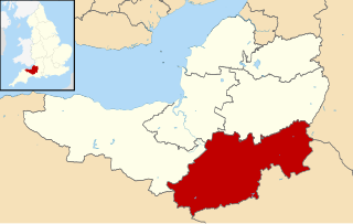
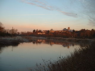
South Somerset is a local government district in the English county of Somerset. The South Somerset district occupies an area of 370 square miles (958 km2), stretching from its borders with Devon and Dorset to the edge of the Somerset Levels. The district has a population of about 158,000, and has Yeovil as its administrative centre.

Hambridge and Westport is a civil parish in Somerset, England. It has a population of 514.

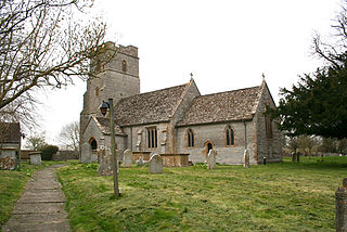
The Church of All Saints in Langport, Somerset, England, has 12th-century origins but was rebuilt in the late 15th century. It is recorded in the National Heritage List for England as a designated Grade I listed building.
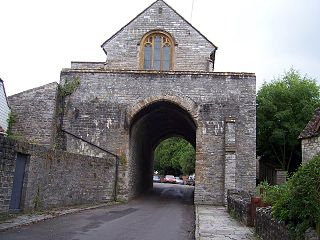
The Hanging Chapel in Langport, Somerset, England is a 13th-century archway, bearing a Perpendicular building known as the hanging chapel. It has been designated as a Grade I listed building, and a Scheduled Ancient Monument.
Tudor House may refer to: