Related Research Articles

Douglas County is one of the 36 counties in the U.S. state of Oregon. As of the 2010 census, the population was 107,667. The county seat is Roseburg. It is named after Stephen A. Douglas, an American politician who supported Oregon statehood. Douglas County comprises the Roseburg, OR Micropolitan Statistical Area.
Umpqua County was a county located in the U.S. state of Oregon. It was created on January 24, 1851, by the Oregon Territorial Legislature embracing the lands along the Umpqua River in southwestern Oregon. Gold had been discovered in the Umpqua region, which brought a rapid increase of settlers to the new county. The first meeting of the Umpqua County Court was in Elkton in 1852; later the county government was moved to Green Valley and Yoncalla.

The Umpqua River on the Pacific coast of Oregon in the United States is approximately 111 miles (179 km) long. One of the principal rivers of the Oregon Coast and known for bass and shad, the river drains an expansive network of valleys in the mountains west of the Cascade Range and south of the Willamette Valley, from which it is separated by the Calapooya Mountains. From its source northeast of Roseburg, the Umpqua flows northwest through the Oregon Coast Range and empties into the Pacific at Winchester Bay. The river and its tributaries flow almost entirely within Douglas County, which encompasses most of the watershed of the river from the Cascades to the coast. The "Hundred Valleys of the Umpqua" form the heart of the timber industry of southern Oregon, generally centered on Roseburg.
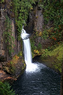
Toketee Falls is a waterfall in Douglas County, Oregon, United States, on the North Umpqua River at its confluence with the Clearwater River. It is located approximately 58 miles (93 km) east of Roseburg near Oregon Route 138.

Umpqua Community College (UCC) is a public community college approximately six miles (9.7 km) north of Roseburg, Oregon. The college has sixteen campus buildings located on 100 acres (40 ha) bordering the North Umpqua River. The campus also features a track, tennis courts, and an outdoor pool. In 2009, a vineyard was added to the campus. About 3,300 full-time students and 16,000 part-time students attend UCC. Umpqua Community College serves the greater Douglas County region with the exception of Reedsport and its immediate area along the Oregon Coast.

Sutherlin is a city in Douglas County, Oregon, United States. As of the 2010 Census, the population was 7,810, making it the second most populous city in Douglas County. Located off of I-5, nearby features include Cooper Creek Reservoir, Ford's pond, the Umpqua River, a golf course, and numerous vineyards.

The Southern Oregon AVA, is an American Viticultural Area which lies in Southern Oregon, United States. The Southern Oregon AVA was established in 2004 and was created to include the land of two smaller AVAs: the Rogue Valley AVA and the Umpqua Valley AVA. Southern Oregon AVA was established to allow the two principal winegrowing regions in the southern part of the state to market themselves jointly. This creation of a "super-AVA" is a departure from the trend in the Willamette Valley AVA or northern Oregon of establishing smaller AVAs specific to a particular locale's climate or soil conditions.

The Umpqua Valley AVA is one of the first American Viticultural Area (AVA) in Oregon and located entirely within Douglas County, Oregon. It became a sub-appellation within the larger Southern Oregon AVA when it was established in 2004. Its boundaries are detailed in Code of Federal Regulations, Title 27 Chapter I Part 9 section 89(C).

The Oregon Coast Range, often called simply the Coast Range and sometimes the Pacific Coast Range, is a mountain range, in the Pacific Coast Ranges physiographic region, in the U.S. state of Oregon along the Pacific Ocean. This north-south running range extends over 200 miles (320 km) from the Columbia River in the north on the border of Oregon and Washington, south to the middle fork of the Coquille River. It is 30 to 60 miles wide and averages around 1,500 feet (460 m) in elevation above sea level. The coast range has three main sections, a Northern, Central, and Southern.

Winchester is an unincorporated community in Douglas County, Oregon, United States. It is on the south bank of the North Umpqua River 4 miles (6.4 km) north of Roseburg on Interstate 5.
Scottsburg is an unincorporated community in Douglas County, Oregon, United States. It is along the Umpqua River and Oregon Route 38, and is about 20 miles (32 km) from the Pacific Ocean. It was once a growing town but after a large flood in December 1861 the town declined. Scottsburg was named for pioneer Levi Scott.

Fort Umpqua was a trading post built by the Hudson's Bay Company in the company's Columbia District, in what is now the U.S. state of Oregon. It was first established in 1832 and moved and rebuilt in 1836.
Tillamook National Forest was established by the U.S. Forest Service in Oregon on March 2, 1907 with 175,518 acres (710.30 km2). On July 1, 1908, Executive Order 860 assigned a portion to Umpqua National Forest to establish Siuslaw National Forest and the remainder was returned to the public domain. The name was discontinued.

Milo is an unincorporated community in Douglas County, Oregon, United States, about 17 miles (27 km) east of Canyonville on the South Umpqua River.
Shady is an unincorporated community in Douglas County, Oregon, United States. It is about two miles south of Roseburg on a stretch of Oregon Route 99 also known as the Oakland-Shady Highway. Shady is outside Roseburg's urban growth boundary, but it does have sewer service. Because of sewer availability, Douglas County considers Shady an "urban unincorporated area". It is next to the South Umpqua River.
Nonpareil is an unincorporated historic community in Douglas County, Oregon, United States. It is about 8 miles (13 km) east of Sutherlin, near Calapooya Creek. The population of the area was about 202 in 2000. Nonpareil was the birthplace of novelist H. L. Davis.
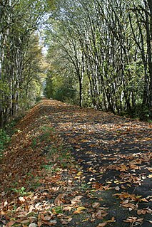
Row River National Recreation Trail is a rails to trails conversion in the U.S. state of Oregon. It follows the Row River for 16.2 miles (26.1 km) between Cottage Grove and Culp Creek, passing by Dorena Lake, and provides access to many forest trails of Umpqua National Forest.
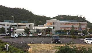
Mercy Medical Center is a rural non-profit community hospital located in the city of Roseburg, in the US State of Oregon. Mercy Medical Center has 171 licensed beds on a 90-acre (36 ha) campus, and the hospital has a heliport for patients arriving to the emergency department via helicopter. The hospital is accredited by the Joint Commission on Accreditation of Healthcare Organizations. Mercy Medical Center is the only hospital in Douglas County, Oregon, and has been since 2000. With 1,139 employees, the hospital is the second largest employer in the county, and in Roseburg.

Myrtle Creek is a short tributary of the South Umpqua River in Douglas County in the U.S. state of Oregon. Its main stem, formed by the confluence of two forks just south of the city of Myrtle Creek, is only about 1 mile (1.6 km) long. Its only named tributaries are the two forks, North Myrtle Creek and South Myrtle Creek, each of which is much longer than the main stem.
Galesville Reservoir is a water storage reservoir in Klamath Mountains of Douglas County, Oregon. The dam was completed in October 1986.