
The Virginia General Assembly is the legislative body of the Commonwealth of Virginia, the oldest continuous law-making body in the Western Hemisphere, the first elected legislative assembly in the New World and was established on July 30, 1619.
Redistricting in the United States is the process of drawing electoral district boundaries. For the United States House of Representatives, and state legislatures, redistricting occurs after each decennial census.

North Carolina is currently divided into 14 congressional districts, each represented by a member of the United States House of Representatives. After the 2000 census, the number of North Carolina's seats was increased from 12 to 13 due to the state's increase in population. In the 2022 elections, per the 2020 United States census, North Carolina gained one new congressional seat for a total of 14.
Minnesota is currently divided into eight congressional districts, each represented by a member of the United States House of Representatives. After the 2020 census, the number of Minnesota's seats remained unchanged.

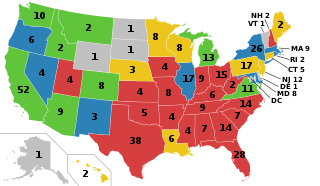
California is the most populous U.S. state; as a result, it has the most representation in the United States House of Representatives, with 52 Representatives. Each Representative represents one congressional district.

Wisconsin is currently divided into 8 congressional districts, each represented by a member of the United States House of Representatives. After the 2020 census, the number of Wisconsin's seats remained unchanged.

Florida is divided into 28 congressional districts, each represented by a member of the United States House of Representatives. After the 2020 census, the number of Florida's seats was increased from 27 to 28, due to the state's increase in population, and subsequent reapportionment in 2022.

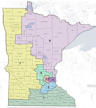
Virginia is currently divided into 11 congressional districts, each represented by a member of the United States House of Representatives. The death of Rep. Donald McEachin on November 28, 2022, left the 4th congressional district seat empty. Following the results of a special election to fill his seat on February 21, 2023, Jennifer McClellan made history by becoming Virginia's first black congresswoman.

In the United States, a redistricting commission is a body, other than the usual state legislative bodies, established to draw electoral district boundaries. Generally the intent is to avoid gerrymandering, or at least the appearance of gerrymandering, by specifying a nonpartisan or bipartisan body to comprise the commission drawing district boundaries.

The following is a list of the ten congressional districts in the U.S. state of Washington. From the time that Washington Territory was formed in 1853, through statehood in 1889, Washington Territory elected an at-large non-voting Delegate to the United States House of Representatives. At different times in its history, the state of Washington has also elected one or more representatives At-large statewide. Washington gained its 10th district following reapportionment after the 2010 census.
The California Citizens Redistricting Commission is the redistricting commission for the State of California responsible for determining the boundaries of districts for the State Senate, State Assembly, and Board of Equalization. The commission was created in 2010 and consists of 14 members: five Democrats, five Republicans, and four from neither major party. The commission was created following the passage in November 2008 of California Proposition 11, the Voters First Act. The commissioners were selected in November and December 2010 and were required to complete the new maps by August 15, 2011.

The California state elections was held on Election Day, November 6, 2012. On the ballot were eleven propositions, various parties' nominees for the United States presidency, the Class I Senator to the United States Senate, all of California's seats to the House of Representatives, all of the seats of the State Assembly, and all odd-numbered seats of the State Senate.

The U.S. state of Arizona, in common with the other U.S. states, must redraw its congressional and legislative districts every ten years to reflect changes in the state and national populations. Redistricting normally follows the completion of the United States census, which is carried out by the federal government the first year of every decade; the most recent census took place in 2020. Historically, Arizona's legislature had control over the redistricting process. However, Proposition 106, passed in 2000, delegated the power to draw congressional and legislative boundaries to a bipartisan independent commission. The Arizona Independent Redistricting Commission (AIRC) comprises two Democrats, two Republicans, and one independent chair. County and local redistricting, which normally takes place along the same timeline as congressional and legislative redistricting, is carried out by the individual county and local governments rather than the AIRC.
Gerrymandering is the practice of setting boundaries of electoral districts to favor specific political interests within legislative bodies, often resulting in districts with convoluted, winding boundaries rather than compact areas. The term "gerrymandering" was coined after a review of Massachusetts's redistricting maps of 1812 set by Governor Elbridge Gerry noted that one of the districts looked like a mythical salamander.
Redistricting in California has historically been highly controversial. Critics have accused legislators of attempting to protect themselves from competition by gerrymandering districts. Conflicts between the governor and the legislature during redistricting often have only been resolved by the courts.

The 2020 United States redistricting cycle is in progress following the completion of the 2020 United States census. In all fifty states, various bodies are re-drawing state legislative districts. States that are apportioned more than one seat in the United States House of Representatives are also drawing new districts for that legislative body.
Redistricting has been a controversial topic in Virginia due to allegations of gerrymandering. In the 2017 Virginia General Assembly, all of the redistricting reform bills were killed.

Redistricting in Wisconsin is the process by which boundaries are redrawn for municipal wards, Wisconsin State Assembly districts, Wisconsin State Senate districts, and Wisconsin's congressional districts. Redistricting typically occurs—as in other U.S. states—once every decade, usually in the year after the decennial United States census. According to the Wisconsin Constitution, redistricting in Wisconsin follows the regular legislative process, it must be passed by both houses of the Wisconsin Legislature and signed by the Governor of Wisconsin—unless the Legislature has sufficient votes to override a gubernatorial veto. Due to political gridlock, however, it has become common for Wisconsin redistricting to be conducted by courts. The 1982, 1992, and 2002 legislative maps were each enacted by panels of United States federal judges; the 1964 and 2022 maps were enacted by the Wisconsin Supreme Court.
The 2010 United States redistricting cycle took place following the completion of the 2010 United States census. In all fifty states, various bodies re-drew state legislative districts. States that are apportioned more than one seat in the United States House of Representatives also drew new districts for that legislative body. The resulting new districts were first implemented for the 2011 and 2012 elections.
Smiley v. Holm, 285 U.S. 355 (1932), was a decision of the Supreme Court of the United States involving a governor's power to veto a congressional redistricting proposal passed by a state's legislature. In an opinion by Chief Justice Charles Evans Hughes, the Court unanimously held that the U.S. Constitution did not prohibit Minnesota's governor from vetoing that state's redistricting map.


