
Historic Denbighshire is one of thirteen traditional counties in Wales, a vice-county and a former administrative county, which covers an area in north east Wales. It is a maritime county, bounded to the north by the Irish Sea, to the east by Flintshire, Cheshire and Shropshire, to the south by Montgomeryshire and Merionethshire, and to the west by Caernarfonshire.

Barnet was a local government district in south Hertfordshire from 1863 to 1965 around the town of Barnet.
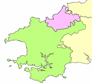
Maelor was a rural district in the administrative county of Flintshire, Wales, from 1894 to 1974. The area approximated to the hundred of Maelor or English Maelor, and was notable for forming a detached part of the county, surrounded by Cheshire, Denbighshire and Shropshire. The administrative centre was located at Overton.
Wharfedale was a rural district in the West Riding of Yorkshire from 1894 to 1974. It comprised the northern side of lower Wharfedale, the lower Washburn Valley and several parishes between Leeds and the River Wharfe. Until 1937 it also included a detached part, the parish of Esholt north of Bradford.
Escrick was a rural district in the East Riding of Yorkshire from 1894 to 1935.
Riccal was a rural district in the East Riding of Yorkshire, England from 1894 to 1935.
Howden was a rural district in the East Riding of Yorkshire, England from 1894 to 1974.
St Dogmells was a rural district in the administrative county of Pembrokeshire, Wales from 1894 to 1934.
Hiraethog was a rural district of the administrative county of Denbighshire, Wales, from 1935 to 1974. The district took its name from the historic district of Mynydd Hiraethog.
Holywell was a rural district in the administrative county of Flintshire, Wales, from 1894 to 1974.
Dwyran was a rural district in the administrative county of Anglesey, Wales from 1894 to 1933.
Twrcelyn was a rural district in the administrative county of Anglesey, Wales, from 1894 to 1974. The district took its name from Twrcelyn, one of the ancient cwmwds or medieval subdivisions of the island.
Valley was a rural district part of the administrative county of Anglesey, Wales from 1894 to 1974.
Beverley was a rural district in the East Riding of Yorkshire, England from 1894 to 1974.
Driffield was a rural district in the East Riding of Yorkshire in England from 1894 to 1974. It surrounded the municipal borough of Driffield.

Patrington was a rural district in the East Riding of Yorkshire, England, from 1894 to 1935.
Pocklington was a rural district in the East Riding of Yorkshire, England from 1894 to 1974.
Sculcoates was a rural district in the East Riding of Yorkshire, England from 1894 to 1935.
Skirlaugh was a rural district in the East Riding of Yorkshire, England from 1894 to 1935.