A land mine is an explosive device concealed under or on the ground and designed to destroy or disable enemy targets, ranging from combatants to vehicles and tanks, as they pass over or near it. Such a device is typically detonated automatically by way of pressure when a target steps on it or drives over it, although other detonation mechanisms are also sometimes used. A land mine may cause damage by direct blast effect, by fragments that are thrown by the blast, or by both.

Mining is the extraction of valuable minerals or other geological materials from the earth, usually from an ore body, lode, vein, seam, reef or placer deposit. These deposits form a mineralized package that is of economic interest to the miner.

The Northwest Territories is a federal territory of Canada. At a land area of approximately 1,144,000 km2 (442,000 sq mi) and a 2016 census population of 41,786, it is the second-largest and the most populous of the three territories in Northern Canada. Its estimated population as of 2018 is 44,445. Yellowknife became the territorial capital in 1967, following recommendations by the Carrothers Commission.

A naval mine is a self-contained explosive device placed in water to damage or destroy surface ships or submarines. Unlike depth charges, mines are deposited and left to wait until they are triggered by the approach of, or contact with, any vessel. Naval mines can be used offensively, to hamper enemy shipping movements or lock vessels into a harbour; or defensively, to protect friendly vessels and create "safe" zones.
Mine, mines, miners or mining may refer to:

Coal mining is the process of extracting coal from the ground. Coal is valued for its energy content, and, since the 1880s, has been widely used to generate electricity. Steel and cement industries use coal as a fuel for extraction of iron from iron ore and for cement production. In the United Kingdom and South Africa, a coal mine and its structures are a colliery, a coal mine a pit, and the above-ground structures the pit head. In Australia, "colliery" generally refers to an underground coal mine. In the United States, "colliery" has been used to describe a coal mine operation but nowadays the word is not commonly used.
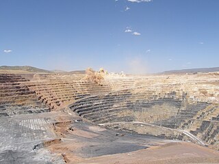
Open-pit, open-cast or open cut mining is a surface mining technique of extracting rock or minerals from the earth by their removal from an open pit or borrow.

A minesweeper is a small naval warship designed to engage in minesweeping. Using various mechanisms intended to counter the threat posed by naval mines, waterways are kept clear for safe shipping.

"Sweet Child o' Mine" is a song by American rock band Guns N' Roses, appearing on their debut album, Appetite for Destruction. Released in August 1988 as the album's third single, the song topped the Billboard Hot 100 chart, becoming the band's only number 1 US single. Billboard ranked it the number 5 song of 1988. Re-released in 1989, it reached number 6 on the UK Singles Chart. Guitarist Slash said in 1990, "[The song] turned into a huge hit and now it makes me sick. I mean, I like it, but I hate what it represents."

Minelaying is the act of deploying explosive mines. Historically this has been carried out by ships, submarines and aircraft. Additionally, since World War I the term minelayer refers specifically to a naval ship used for deploying naval mines. "Mine planting" was the term for installing controlled mines at predetermined positions in connection with coastal fortifications or harbor approaches that would be detonated by shore control when a ship was fixed as being within the mine's effective range.

Rio Tinto is an Anglo-Australian multinational and one of the world's largest metals and mining corporations. The company was founded in 1873, when a multinational consortium of investors purchased a mine complex on the Rio Tinto, in Huelva, Spain, from the Spanish government. Since then, the company has grown through a long series of mergers and acquisitions to place itself among the world leaders in the production of many commodities, including aluminium, iron ore, copper, uranium, and diamonds. Although primarily focused on extraction of minerals, Rio Tinto also has significant operations in refining, particularly for refining bauxite and iron ore. The company has operations on six continents, but is mainly concentrated in Australia and Canada, and owns its mining operations through a complex web of wholly and partly owned subsidiaries. Rio Tinto has joint head offices in London and Melbourne.

Gold mining is the resource extraction of gold by mining.
The following lists events that happened during 1950 in South Africa.
The following lists events that happened during 1946 in South Africa.

Empire Mine State Historic Park is a state-protected mine and park in the Sierra Nevada Mountains in Grass Valley, California, US. The Empire Mine is on the National Register of Historic Places, a federal Historic District, and a California Historical Landmark. Since 1975 California State Parks has administered and maintained the mine as a historic site. The Empire Mine is "one of the oldest, largest, deepest, longest and richest gold mines in California". Between 1850 and its closure in 1956, the Empire Mine produced 5.8 million ounces of gold, extracted from 367 miles (591 km) of underground passages.

Auchy-les-Mines is a commune in the Pas-de-Calais department in the Hauts-de-France region of France. Until 1926 it was named Auchy-lez-La-Bassée.
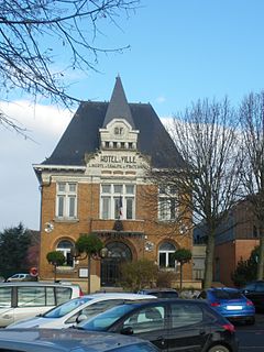
Vermelles is a commune in the Pas-de-Calais department in the Hauts-de-France region of France.
According to the United States Energy Information Administration (EIA), Pakistan may have over 9 billion barrels (1.4×10⁹ cubic metres) of petroleum oil and 105 trillion cubic feet (3.0 trillion cubic metres) in natural gas (including shale gas) reserves.
Minesweeper is a single-player puzzle video game. The objective of the game is to clear a rectangular board containing hidden "mines" or bombs without detonating any of them, with help from clues about the number of neighboring mines in each field. The game originates from the 1960s, and has been written for many computing platforms in use today. It has many variations and offshoots.
The R575 is a Regional Route in South Africa. Its northern origin is the R555 just west of Middelburg, Mpumalanga. It heads south-south-west to end at the R544 just north of Vandyksdrif.