Vasheni

Last updated

Vasheni
Village
India Maharashtra location map.svg
Red pog.svg
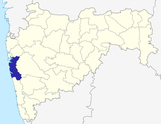
Vasheni
Location in Kokan, Maharashtra, India
India location map.svg
Red pog.svg
Vasheni
Vasheni (India)
Coordinates: 18°50′0″N73°0′27″E / 18.83333°N 73.00750°E / 18.83333; 73.00750 Coordinates: 18°50′0″N73°0′27″E / 18.83333°N 73.00750°E / 18.83333; 73.00750
CountryFlag of India.svg  India
State Maharashtra
District Raigad
Area
[1]
  Total861 ha (2,128 acres)
Population
  Total3,500 [1]
Languages
  Official Marathi
Time zone UTC+5:30 (IST)
PIN
400702
Nearest city Uran, Pen, Panvel Shivajinagar
Vasheni Vasheni.jpg
Vasheni

Vasheni is a village in Uran Taluka, Maharashtra state, India. The most common occupations in Vasheni are farmers, fishers and teachers. Uran, Pen and Panvel are the nearest towns or cities. The population of the village is 3,700. There are mainly Four sectors (nickname-Aali)

Maharashtra State in western India

Maharashtra is a state in the western peninsular region of India occupying a substantial portion of the Deccan Plateau. It is the second-most populous state and third-largest state by area in India. Spread over 307,713 km2 (118,809 sq mi), it is bordered by the Arabian Sea to the west, the Indian states of Karnataka and Goa to the south, Telangana to the southeast and Chhattisgarh to the east, Gujarat and Madhya Pradesh to the north, and the Indian union territory of Dadra and Nagar Haveli to the north west. It is also the world's second-most populous subnational entity.

Uran Nodal Town of Navi Mumbai in Maharashtra, India

Uran is a coastal town and part of Navi Mumbai, Maharashtra state in Konkan division. It lies in the Raigad district, east of Mumbai across the Dharamtar Creek. Uran is primarily a fishing and agriculture village, which has developed into the special economic zone of Uran. The primary languages spoken are Agri and Koli which is a dialect of Marathi-Kokani.

Pen, India Place in Maharashtra, India

Pen is a town and taluka in Raigad district of Indian state of Maharashtra. It is well-known for world class Ganesh idols. It is geographical and cultural center of Raigad district.

  1. Varchi Aali
  2. Khalchi Aali
  3. Tep Aali
  4. Belpada
  5. Maath Aali
  6. Dandeshwar

Vasheni is mainly occupied by people of Agri caste, for whom farming and fishing are main occupations of people. There are large numbers of teachers in Vasheni village. Vasheni has a high education rate compared to other villages.

Vasheni is also natural place where the sea and hills are present.

Important Places

  1. Mari Aai Mandir (Jari Mari)
  2. Hanuman Mandir
  3. Radhakrishna Mandir
  4. Bahiridev Mandir
  5. Vasheni-Dadar Bridge
  6. Punade Dam
  7. Bapdev Mandir
  8. Vasheni-Uran HighWay

There are also sport activities in this village. Cricket activities are started from the December.

In the district the Vasheni village has the highest number of Facebook Accounts.

There are following schools in vasheni village

  1. Raigad Jilha Parishad Shala Vasheni (Khalchi Aali)
  2. Raigad Jilha Parishad Shala Vasheni (Varchi Aali)
  3. Chhatrapati Shivaji Maharaj High School Vasheni
  4. Raigad Educaution Society English Medium School Vasheni

Related Research Articles

Wai, Maharashtra city in Maharashtra, India

Wai is a town in Sātārā District, in Mahārāshtra state, India.

Raigad district District of Maharashtra in India

Raigad District is a district in the state of Maharashtra, India. Formerly called the Kolába district, the district was renamed Raigad, after the fort that was the first capital of the former Maratha Empire, which in turn was renamed from its earlier name - Rairi. The fort is located in the interior regions of the district, in dense forests on a west-facing spur of the Western Ghats of Sahyadri Range. In 2011 the district had a population of 2,635,394, compared to 2,207,929 in 2001. The name was changed in the regime of Chief Minister Antule on 1st Jan 1981. In 2011 urban dwellers had increased to 36.91% from 24.22% in 2001.

Kabnur city in Maharashtra, India

Kabnur is a census town near Ichalkaranji in Kolhapur district Maharashtra.

Nagothana town in Maharashtra, India

Nagothana is a census town in Raigad district in the Indian state of Maharashtra.

Kavathe-Mahankal City in Maharashtra, India

Kavathe-Mahankalpronunciation  is a tehsil in Miraj subdivision of Sangli district in the Indian state of Maharashtra. This is famous for Mahankali Devi temple and Mallikarjun Temple. There is also a Sugar Factory, named after the same Goddess Mahankali Sugar Factory.

Nashirabad Town in Maharashtra, India

Nashirabad is a small town in Jalgaon district in the northern Maharashtra state in India. It was named after Nasiruddin Badshah. The earlier name of the town was Solnimbhore. This was due to fact that the town had 16 Hanuman temples and 16 main doors.

Takali Dhokeshwar village in Maharashtra, India

Takali Dhokeshwar is a village in Ahmednagar District, Maharashtra, India. It is located at the intersection of the Mumbai - Vishakhapattanam highway and the Satara - Nashik road.

Alkuti Place in Maharashtra, India

Alkuti is a village in Parner taluka, Ahmadnagar district of Maharashtra state in Indian territory.

Wasunde village in Maharashtra, India

Wasunde, is the only village in the Vasunde gram panchayat in the Parner Taluka of the Ahmednagar District, state of Maharashtra, India. The village is 4.8 km by road north of Takli Dhokeshwar on State Highway 50.

Nighoj village in Maharashtra, India

Nighoj is a village in Ahmednagar District, Maharashtra, India. It is about 90 kilometres away from Pune and is famous for the naturally created potholes (tinajas) on the riverbed of the Kukadi River. Experts from all over the world come here every year to study the phenomenon of their formation.

Babhulwade Village in Maharashtra, India

Babhulwade, is a village in Parner taluka in Ahmednagar district of state of Maharashtra, India. It is a village located on intersection of Shirur - Kalyan. It is famous about Swayambhu Shree Kedareshwar Temple.

Pimpalner, Parner Village in Maharashtra, India

Pimpalner, is a small town in Parner Taluka in Ahmednagar district of state of Maharashtra, India. It belongs to Nashik Division. It is located 49 km to the west of District headquarters Ahmednagar. 12 km from Parner. 189 km from State capital Mumbai. Pimpalner is surrounded by Parner Taluka to the north, Ahmednagar Taluka to the east, Shrigonda Taluka to the south, Khed Taluka to the west. Shirur, Ahmednagar, Shrigonda, Manchar are the nearby cities to Pimpalner.

Ralegan Therpal is a village in Parner taluka in Ahmednagar district of state of Maharashtra, India. The village is about 12 km from Shirur.

Sherikasare village in Maharashtra, India

Sherikasari is a newly separated small village from Alkuti village of Parner Taluka in Ahmednagar District of state of Maharashtra, India.

Pimpalgaon Raja Village in Maharashtra, India

Pimpalgaon Raja is a gram panchayat located in tahsil Khamgaon of Buldhana district of Maharashtra situated on bank of River Dnyanganga. It is 14 km from Khamgaon.Pimpalgaon Raja is a large village located in Khamgaon of Buldana district.

Alur, Osmanabad village in Maharashtra, India

Alur is a panchayat village in the state of Maharashtra, India. Administratively, Alur is under Umarga Tahsil of Osmanabad District in Maharashtra. There is only the single village of Alur in the Alur gram panchayat. The village of Alur is 31 km by road southeast of the town of Naldurg and 52 km by road southwest of the town of Umarga, but only 13 km by road northeast of Wagdari, in Solapur District.

Gadilgaon Village in Maharashtra, India

Gadilgaon is a village in Parner taluka in Ahmednagar district of state of Maharashtra, India.

Sarde Village in Maharashtra, India

Sarde is an Indian village in the Tehsil of Uran of the Raigad District of the Indian state of Maharashtra.

Beed Kh. village is located in Khalapur Tehsil of Raigad district in Maharashtra, India. It is situated 13 km away from sub-district headquarter Khalapur and 66 km away from district headquarter Alibag. Beed Khurd is the gram panchayat of Beed Kh village.

References

  1. 1 2 Directorate of Census Operations Maharashtra (2011). "Census of India, 2011: Maharashtra (Series-28, Part XII-B), District Census Handbook – Raigarh. Village and Town Wise Primary Census Abstract (PCA)" (PDF). pp. 116–121.