Vejle Fjord

Last updated
Vejle Fjord Bridge Vejlefjordbroen2.jpg
Vejle Fjord Bridge

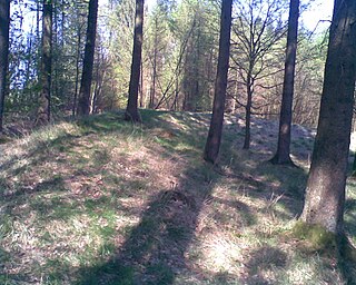
Vejle Fjord is an East Jutland-type fjord in Denmark. It is approximately 22 km (14 mi) in length, and it stretches east from the town of Vejle at its head to the towns of Trelde Næs on the south side and Juelsminde on the north side at the mouth. The fjord's generally calm surface waters are surrounded by low forested hills shaped by glaciers during the last ice age. [1]

Förden and East Jutland Fjorde

The eastern coast of the Jutland Peninsula, consisting of Danish Jutland and German Schleswig-Holstein features a type of narrow bay called Förde in German and fjord in Danish. These bays are of glacial origin, but the glacial mechanics were different from those of Norwegian Fjords and also from those of Swedish and Finnish Fjards.

Denmark constitutional monarchy in Europe

Denmark, officially the Kingdom of Denmark, is a Nordic country and the southernmost of the Scandinavian nations. Denmark lies southwest of Sweden and south of Norway, and is bordered to the south by Germany. The Kingdom of Denmark also comprises two autonomous constituent countries in the North Atlantic Ocean: the Faroe Islands and Greenland. Denmark proper consists of a peninsula, Jutland, and an archipelago of 443 named islands, with the largest being Zealand, Funen and the North Jutlandic Island. The islands are characterised by flat, arable land and sandy coasts, low elevation and a temperate climate. Denmark has a total area of 42,924 km2 (16,573 sq mi), land area of 42,394 km2 (16,368 sq mi), and the total area including Greenland and the Faroe Islands is 2,210,579 km2 (853,509 sq mi), and a population of 5.8 million.

Vejle Town in Southern Denmark, Denmark

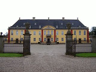
Vejle is a town in Denmark, in the southeast of the Jutland Peninsula at the head of Vejle Fjord, where the Vejle River and Grejs River and their valleys converge. It is the site of the councils of Vejle Municipality (kommune) and the Region of Southern Denmark. The city has a population of 54,862, making it the ninth largest city in Denmark. Vejle Municipality has a population of 111,743. The city is part of the Triangle Region, which includes the neighbouring cities of Kolding and Fredericia.

Public works projects have re-shaped the small rivers and countryside surrounding the fjord since the Middle Ages.

Middle Ages Period of European history from the 5th through the 15th centuries

In the history of Europe, the Middle Ages lasted from the 5th to the 15th century. It began with the fall of the Western Roman Empire and merged into the Renaissance and the Age of Discovery. The Middle Ages is the middle period of the three traditional divisions of Western history: classical antiquity, the medieval period, and the modern period. The medieval period is itself subdivided into the Early, High, and Late Middle Ages.

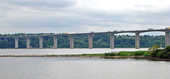
Highway E45 crosses the fjord just east of the town of Vejle on the Vejle Fjord Bridge. [2]

European route E45 road in Europe

The European route E 45 goes between Norway and Italy, through Finland, Sweden, Denmark, Germany and Austria. With a length of about 5,190 kilometres (3,225 mi), it is the longest north-south European route.

Vejle Fjord Bridge

Vejle Fjord Bridge is a cantilever bridge that spans Vejle Fjord between Mølholm and Nørremarken near the town of Vejle in Denmark. The bridge is 1712 metres long, the longest span is 110 metres, and the maximum clearance to the sea is 40 metres. The bridge has 15 spans and carries the European route E45 over the fjord.

See also

Related Research Articles

Kattegat sea area between Denmark and Sweden

The Kattegat is a 30,000 km2 (12,000 sq mi) sea area bounded by the Jutlandic peninsula in the west, the Danish Straits islands of Denmark to the south and the provinces of Västergötland, Scania, Halland and Bohuslän in Sweden in the east. The Baltic Sea drains into the Kattegat through the Danish Straits. The sea area is a continuation of the Skagerrak and may be seen as a bay of the Baltic Sea or the North Sea or, as in traditional Scandinavian usage, neither of these.

Odense City in Southern Denmark, Denmark

Odense is the third-largest city in Denmark. It has a population of 178,210 as of January 2016, and is the main city of the island of Funen. By road, Odense is located 45 kilometres (28 mi) north of Svendborg, 144 kilometres (89 mi) to the south of Aarhus and 167 kilometres (104 mi) to the southwest of Copenhagen. The city is the seat of Odense Municipality and was the seat of Odense County until 1970, and Funen County from 1970 until 1 January 2007, when Funen County became part of the Region of Southern Denmark. Odense has close associations with Hans Christian Andersen who is remembered above all for his fairy tales. He was born in the city in 1805 and spent his childhood years there.

Zealand Largest and most populous island in Denmark proper

Zealand, at 7,031 km2, is the largest and most populous island in Denmark proper. Zealand has a population of 2,302,074.

Little Belt Strait in Denmark linking the Baltic Sea to the Kattegat strait and the Atlantic Ocean

The Little Belt is a strait between the island of Funen and the Jutland Peninsula in Denmark. It is one of the three Danish Straits that drain and connect the Baltic Sea to the Kattegat strait, which drains west to the North Sea and Atlantic Ocean.

Grindsted with a population of 9,768 (2018) is the municipal seat and largest town of Billund Municipality, Denmark and belongs to the Region of Southern Denmark. It is located 42 km west of the major regional city of Vejle and 49 km northeast of the major harbour city Esbjerg. The postal code is 7200.

Svanholm

Svanholm is a country estate and former manor 55 kilometres (34 mi) west of Copenhagen, Denmark. In 1978 an association of over 100 persons bought the estate to create Denmark's largest intentional community. The Svanholm Collective grows its own food and was one of the pioneers of organic farming in Denmark. As of January 2006, membership consisted of 70 adults and 35 children aged 0 to 80, jointly owning around 400 hectares of farmland, park, and woodlands.

Svaneke Town in Capital, Denmark

Svaneke is a small town on the eastern coast of the Baltic island of Bornholm, Denmark. It lies mainly in Svaneke parish and partly in Ibsker parish.

Frederikssund Place in Capital, Denmark

Frederikssund is a Danish town, seat of the Frederikssund Municipality, in the Region Hovedstaden with a population of 15,865. It received the status of market town in 1810. The town is famous for its annual Viking Games as well as for the J.F. Willumsen museum. Since 1935, it has been connected to Hornsherred via the Kronprins Frederik Bridge.

Ise Fjord bay in Zealand, Denmark

Ise Fjord is a deeply branched arm of the sea into the Danish island Zealand. From its relatively narrow entrance from the Kattegat at Hundested and Rørvig, branches of Ise Fjord stretch 35 km inland and divide the northern part of Zealand into the peninsulas of Odsherred, Hornsherred, and Nordsjælland.

Horsens Fjord

Horsens Fjord is an East Jutland-type fjord in the east coast of the Danish peninsula of Jutland which stretches from the islands of Alrø and Hjarnø in the east to the town of Horsens on the mainland. It is some 20 kilometres (12 mi) long. The navigational channel to Horsens has a depth of 7 metres (23 ft).

Glænø island

Glænø is a small Danish island off the west coast of Zealand between Basnæs Nor and Karrebæksminde Bugt. With an area of 5.6 square kilometres, as of 1 January 2010 it has a population of 57. Now part of Slagelse Municipality, it is connected to Stubberup, Zealand, by road over a dam some 100 metres long. Agriculture is the island's main source of income and there are several farms at the centre of the island. Glænø has a sandy beach, a bird sanctuary and offers opportunities for walking and angling.

Enø Danish island

Enø is a small Danish island off the west coast of Zealand between Karrebæk Fjord and Karrebæksminde Bugt. With an area of 3.4 square kilometres, as of 1 January 2010 it has a population of 297. It is some 5 kilometres long and up to 11 metres above sea level. Now part of Næstved Municipality, it is connected to Karrebæksminde, Zealand, by a road bridge. There are about 1,000 summerhouses and a holiday centre at Enø By on the northern part of the island. EnøOverdrev in the southern part is a nature reserve and bird sanctuary.

Andkær

Andkær is a small town in Southern Jutland, Denmark. It is located eight kilometres to the south-east of Vejle. It is part of Vejle Municipality, and has a population of 376.

Peter Hvidt (1916–1986) was a Danish architect and furniture designer, co-founder of Hvidt & Mølgaard.

Orla Mølgaard-Nielsen (1907–1993) was a Danish architect and furniture designer. After training at the Aalborg Technical School (1924) and at the Art and Crafts School of the Design Museum in Copenhagen (1928), Mølgaard-Nielsen studied furniture design under Kaare Klint at the Royal Danish Academy of Fine Arts (1931–1934). His work, which from 1944 was carried out mainly in partnership with Peter Hvidt at the Hvidt & Mølgaard studio, can be divided into three groups: furniture and interior decoration, buildings, and consultency on large bridge projects.

Østerlars Village in Capital (Hovedstaden), Denmark

Østerlars is a village in the northeast of the Danish island of Bornholm, 6 kilometres (3.7 mi) south of Gudhjem and 5 kilometres (3.1 mi) northwest of Østermarie. It is best known for its round church, the largest on the island. In January 2015 it had a population of 251.

Ledreborg

Ledreborg is a palatial mansion near Lejre, 12 km (7.5 mi) to the southwest of Roskilde on the Danish island of Zealand. Today's Baroque building was completed in 1746 by Minister of State Johan Ludvig Holstein (1694–1763) who commissioned J.C. Krieger to carry out the work.

Troldborg Ring ancient monument in Vejle Municipality (60173)

The Troldborg Ring is an Iron Age fortification in Vejle Municipality in Denmark, 13 km (8.1 mi) west of the city of Vejle. It is located at a natural spring on a high point overlooking the Vejle River Valley. The surrounding area is a steep ravine known as the Devil's Valley. The site consists of a raised area of about 1,700 m2 (18,000 sq ft) surrounded by a circular rampart. One side is protected by a steep drop of 70 m (230 ft) to the valley floor, while the other side features a 0.5-metre-deep (1.6 ft), 2.5-metre-wide (8.2 ft) moat.

References

  1. "Vejle Fjord". Den store danske (in Danish). Retrieved 15 June 2010.
  2. "Vejlefjordbroen" [Vejle Fjord Bridge]. Den store danske (in Danish). Retrieved 15 June 2010.

Coordinates: 55°40′N9°45′E / 55.667°N 9.750°E / 55.667; 9.750

Geographic coordinate system Coordinate system

A geographic coordinate system is a coordinate system that enables every location on Earth to be specified by a set of numbers, letters or symbols. The coordinates are often chosen such that one of the numbers represents a vertical position and two or three of the numbers represent a horizontal position; alternatively, a geographic position may be expressed in a combined three-dimensional Cartesian vector. A common choice of coordinates is latitude, longitude and elevation. To specify a location on a plane requires a map projection.