Vester Voldgade

Last updated
Vester Voldgade
Vester Voldgade CPH.jpg
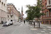
Vester Voldgade with the Copenhagen Town hall tower
Length1,130 m (3,710 ft)
Location Copenhagen, Denmark
Quarter City centre
Postal code1552
Nearest metro station Rådhuspladsen
Coordinates 55°40′29.8″N12°34′19.38″E / 55.674944°N 12.5720500°E / 55.674944; 12.5720500
Northwest end Jarmers Plads
Major
junctions
City Hall Square
Southeast end Christians Brygge

Vester Voldgade (lit. "West Rampart Street") is a street in Copenhagen, Denmark which runs from Jarmers Plads to the waterfront between Frederiksholms Kanal and Langebro, passing the City Hall Square on the way.

Contents

Together with Nørre Voldgade and Øster Voldgade it forms a traffic artery which arches around the Zealand side of central Copenhagen all the way to Kastellet (at Oslo Plads on the coast north of the city centre. The three streets follow the course of Copenhagen's long gone Bastioned Fortification Ring and thus marks the transition between the Old Town and the new neighbourhoods that developed after the fortifications were removed in the second half of the 19th century.

History

The Philosopher's Path seen from the Haymarket, with Lucia Mill on one side and Vejerboden on the other Halmtorvet med Lucie-mollen, Vejerboden og Philosofgangen mod Vartov.png
The Philosopher's Path seen from the Haymarket, with Lucia Mill on one side and Vejerboden on the other
The street in about 1880 Filosofgangen viewed towards Halmtorvet (2).jpg
The street in about 1880
Handvaerkerstiftelsen's building on the corner of Vester Voldgade and Ny Kongensgade, 1900 Handvaerkerstiftelsen (1900).jpg
Håndværkerstiftelsen's building on the corner of Vester Voldgade and Ny Kongensgade, 1900

Vester Voldgade was originally a narrow alley which ran along the inner margin of Copenhagen's West Rampart, part of the Bastioned Fortification Ring which enclosed Copenhagen. The city's haymarket was located at the site of the current City Hall Square until the New Haymarket was inaugurated on 1 January 1888. The section from the haymarket to the harbour was originally known as Filosofgangen (English: Philosopher's Path). That section of the ramparts was one of the last to be decommissioned, surviving until 1885. [1] Lange Bridge was located at the far end of the street until 1903 when it was moved to the end of Vestre Boulevard (now H. C. Andersens Boulevard).

Notable buildings and residents

No. 11 was built for Niels Gade's Music Academy in 1887 in the Renaissance Revival style by Christian L Thuren. It now houses the Russian Center of Science and Culture. [2] No. 19 and 21 are both from the late 1790s and are listed. Hotel Kong Frederik at No. 23-25 first opened in 1900. The building was designed by Phillip Smidth who also designed Politikens Hus on the corner with Vestergade in 190407. The newspaper Politiken has been based in the building since 1912. Vester Voldgade Voldgade 33 is a Functionalist extension from 1934.

The low yellow building at No. 119 is a former hay storage from about 1799, part of the Royal Horse Guards Barracks. The building was originally considerably longer but was shortened when Thorvald Jørgensen's Post Giro Building (No. 133) was built in 1938. [3] The 45-bay, half-timbered building on the other side of the Post Giro Building, part of Fæstningens Materialgård , a former military storage facility, is from 1748.

Vester Voldgade School (89) was completed in 1890 to a design by Ludvig Fenger. It has housed Den Classenske Legatskole since 1938. [4] The low building on the corner of Stormgade (Stormgade 18) was the first home of Overformynderiet which later moved to a new building on Holmens Kanal. The building was designed by Hans Jørgen Holm and is from 1884. [5]

Regnbuepladsen

Regnbuepladsen Regnbuepladsen, Copenhagen, Denmark.jpg
Regnbuepladsen

The small space in front of Vartorv and Palace Hotel, adjoining the City Hall Square, was renovated to a design by Hall McKnight in 2013. The refurbished square received a Civic Trust Award [6] and a RIBA EU Award in 2014. [7] On 1 July 2014, the space was renamed Regnbuepladsen (English: Rainbow Square) in reference to the rainbow flag. [8]

Transport

The main staircase of the Rådhuspladsen Copenhagen Metro station faces the square.

Related Research Articles

Fiolstræde pedestrianized shopping street in central Copenhagen

Fiolstræde is a pedestrianised shopping street in central Copenhagen, Denmark. It passes the square Frue Plads on its way from Nørreport station in the north to Skindergade in the south where Jorcks Passage connects it to the shopping street Strøget. Copenhagen Cathedral is located in the street which also passes the rear side of Copenhagen University Library.

Thorvald Jørgensen architect

Thorvald Jørgensen was a Danish architect, most known for his design of Christiansborg Palace, the seat of the Danish Parliament, after it had been destroyed in a fire. He has also designed a number of churches in Copenhagen. He was Royal Building Inspector from 1911 to 1938.

Nørre Voldgade street in Copenhagen

Nørre Voldgade is a street in central Copenhagen, Denmark. It runs north-east from Jarmers Plads for approximately 600 metres to Gothersgade where it turns into Øster Voldgade. The succession of Nørre Voldgade, Øster Voldgade and Vester Voldgade together forms a traffic artery which arches around the Zealand side of the central and oldest part of Copenhagen. Nørreport Station, Denmark's busiest railway station, is located in the street.

Øster Voldgade street in Copenhagen

Øster Voldgade, together with Vester Voldgade and Nørre Voldgade, forms a succession of large streets which arches around the central and oldest part of the Zealand side of Copenhagen, Denmark. It runs north-east from Gothersgade at Nørreport Station to Georg Brandes Plads, between the Copenhagen Botanical Gardens and Rosenborg Castle Gardens, and continues straight to a large junction at the southern end of Oslo Plads, near Østerport Station, where it turns into Folke Bernadotte Allé.

Royal Horse Guards (Denmark) military unit of the Danish Army

The Royal Horse Guards was a Cuirassier regiment in the Royal Danish Army which was founded on orders from King Frederick III in January 1661 and discontinued on 31 May 1866. It served both as Royal Guards and as a front line cavalry unit.

Royal Horse Guards Barracks (Copenhagen)

The Royal Horse Guards Barracks, at 26 Frederiksholms Kanal in Copenhagen, Denmark, served as barracks for the Royal Horse Guards from 1792 until 1866. The building is located along the south side of a gated alleyway which connects Frederiksholm Canal to Vester Voldgade. Together with Civiletatens Materialgård and Fæstningens Materialgård, it forms a cluster of low, yellow-washed buildings all of which are listed, on the Zealand side of the canal, opposite the small island Slotsholmen with Christiansborg Palace. The Hay Storage Building at the end of the barracks building, facing Vester Voldgade, originally stored hay for the King's horses at the Royal Stables but later also served the Royal Horse Guards. Both the Royal Horse Guards Barracks and the Hay Storage building are now used by the Ministry of Education.

Fæstningens Materialgård

Fæstningens Materialgård is a former military storage facility at 30 Frederiksholms Kanal in Copenhagen, Denmark. Arranged around a central courtyard, the individual buildings have been built to a homogeneous design, all with yellow-washed facades, green doors and gates, white window frames and red tile roofs, but they have in fact been accumulated over an extended period of time, mainly between 1740 and 1925. They also integrate visually and physically with the adjacent Civiletatens Materialgård, a storage facility associated with the royal palaces, and the Royal Horse Guards Barracks, together forming an area of low, yellow buildings surrounded on three sides by Frederiksholm Canal, Bryghusgade and Vester Voldgade.

Frederiksholms Kanal street in Copenhagen Municipality, Denmark

Frederiksholms Kanal is a canal in central Copenhagen, Denmark, which runs along the south-west side of Slotsholmen, together with Slotholmens Kanal separating the island from Zealand. The name also applies to the continuation of Rådhusstræde which follows the canal for most of its course, first on its south side and for the last stretch, from Prinsens Bro and to the waterfront, on both sides of the canal. Several historic buildings face the canal, ranging in size from Prince's Mansion, now housing National Museum, and Christiansborg's riding grounds to the diminutive Stable Boy's House, part of Civiletatens Materialgård, a former storage facility now used by the Royal Danish Academy of Fine Arts's School of Sculpture.

Ved Stranden street in Copenhagen

Ved Stranden is a canal side public space and street which runs along a short section of the Zealand side of Slotsholmen Canal in central Copenhagen, Denmark. It begins at Holmens Kanal, opposite Church of Holmen, and runs west along the canal for one and a half blocks before widening into a small, triangular space adjacent to Højbro Bridge and Højbro Plads. The name of the street refers to Gammel Strand, Old Beach, which it formed part of until 1961.

H. C. Andersens Boulevard boulevard in Copenhagen

H. C. Andersens Boulevard is the most densely trafficated artery in central Copenhagen, Denmark. The 1.3 km long six-lane street passes City Hall Square on its way from Jarmers Plads, a junction just south of Nørreport station, to Lange Bridge which connects it to Amager Boulevard on Amager. From Jarmers Plads traffic continues along Gyldenløvegade which on the far side of The Lakes splits into Aaboulevard and Rosenørns Allé.

Sølvgade street in Copenhagen

Sølvgade is a street in central Copenhagen, Denmark, extending north-west from Borgergade to The Lakes where Fredens Bro connects it to Fredensgade. The section from Kronprinsessegade to Øster Voldgade follows the walled north-eastern margin of Rosenborg Castle Garden and the next section, from Øster Voldgade to the intersection with Farimagsgade, named Sølvtorvet although it is little more than a busy street junction, separates Copenhagen Botanical Garden from Østre Anlæg.

Dantes Plads

Dantes Plads is a public square located in front of the Ny Carlsberg Glyptotek where it connects H. C. Andersens Boulevard to Vester Voldgade in central Copenhagen, Denmark.

Ny Kongensgade street in Copenhagen

Ny Kongensgade is a street in central Copenhagen, Denmark, connecting Frederiksholm Canal to H. C. Andersens Boulevard. In the opposite direction, The Prince's Bridge connects the street to Tøjhusgade on Slotsholmen.

Latin Quarter, Copenhagen neighborhood in Copenhagen

The Latin Quarter is a neighbourhood in central Copenhagen, Denmark. It is bounded by Nørregade to the west, Vestergade to the south, Vester Voldgade to the east and Nørre Voldgade to the north. The name refers to the Latin language, which was once widely spoken in and around the University, whose historic home is situated on the other side of Nørregade. Most of the student life has now been relocated to four new campuses but the area is still known for its lively atmosphere with an abundance of boutiques, cafés and night clubs.

Enghave Plads is a central public square of the Vesterbro district in Copenhagen, Denmark. It is located where Istedgade reaches Enghavevej, which separates the square from Enghave Park.

Ny Vestergade street in Copenhagen

Ny Vestergade is a street in central Copenhagen, Denmark. It runs from Frederiksholms Kanal to Vester Voldgade and together with Christiansborg's riding grounds, Marble Bridge and Dantes Plads forms an axis between Christiansborg's tower in the east and Ny Carlsberg Glyptotek's dome in the west. The National Museum's main entrance is located in the street.

Stormgade street in Copenhagen

Stormgade is a street in central Copenhagen, Denmark. It runs from Frederiksholm Canal to H. C. Andersens Boulevard where it turns into Tietgensgade before continuing along the rear side of Tivoli Gardens and Copenhagen Central Station. In the opposite direction, Storm Bridge connects it to Slotsholmen where traffic may continue across Holmen's Bridge to Holmens Kanal, part of Ring 2, or across Knippel's Bridge to Christianshavn and Amager. The name of the street refers to the Swedish Storm of Copenhagen in 1659.

Vestergade street in Copenhagen

Vestergade is a street in central Copenhagen, Denmark, linking Gammeltorv in the northeast with the City Hall Square in the southwest. The street defines the southern boundary of Copenhagen's Latin Quarter. Most of the buildings in the street date from the years after the Copenhagen Fire of 1795.

Suhmsgade street in Copenhagen

Suhmsgade is a street in the Old Town of Copenhagen, Denmark. It runs from Landemærket to Hauser Plads.

Tietgensgade is a street in central Copenhagen, Denmark. It runs from H. C. Andersens Boulevard in the northeast to Kvægtorvet in the southwest, linking Stormgade in the city centre with Halmtorvet and Sønder Boulevard in Vesterbro. The street follows the rear side of Tivoli Gardens and Copenhagen Central Station. The viaduct that carries it across the railway ltracks at the central station is known as Tietgensbro.

References

  1. "Vester Voldgade" (in Danish). indenforvoldene.dk. Archived from the original on 2014-08-21. Retrieved 2013-11-08.
  2. "Vester Voldgade 11" (in Danish). pisserenden.com. Retrieved 28 September 2015.
  3. "Vester Voldgade 119a-b-123/Frederiksholms Kanal 26-28" (in Danish). indenforvoldene.dk. Archived from the original on 2014-08-22. Retrieved 2013-11-08.
  4. "Skolens historie fra 1725 til 1993:" (PDF) (in Danish). Den Classenske Legatskole. Retrieved 2013-11-08.
  5. "Sag: Overformynderiet (tidl.)" (in Danish). Kulturstyrelsen. Retrieved 2014-01-03.
  6. "Winners in Denmark". Civic Trust Awards. Retrieved 2014-05-24.
  7. "The Best New Buildings". RIBA. Archived from the original on 2014-11-04. Retrieved 2014-06-26.
  8. "Efter et års protester: Nu får København sin Regnbueplads" (in Danish). Politiken. Retrieved 2014-06-29.

Coordinates: 55°40′30″N12°34′19″E / 55.67500°N 12.57194°E / 55.67500; 12.57194