
Victoria Bridge in Nova Scotia
Victoria Bridge is a community in the Canadian province of Nova Scotia, located in the Cape Breton Regional Municipality on Cape Breton Island.
Victoria Bridge is a community in the Canadian province of Nova Scotia, located in the Cape Breton Regional Municipality on Cape Breton Island.

The Gulf of St. Lawrence is the outlet of the North American Great Lakes via the St. Lawrence River into the Atlantic Ocean. The gulf is a semi-enclosed sea, covering an area of about 226,000 square kilometres (87,000 sq mi) and containing about 34,500 cubic kilometres (8,300 cu mi) of water, at an average depth of 152 metres (500 ft).
The Cabot Trail is a scenic highway on Cape Breton Island in Nova Scotia, Canada. It is a 298 km (185 mi) loop around the northern tip of the island, passing along and through the Cape Breton Highlands and the Cape Breton Highlands National Park.
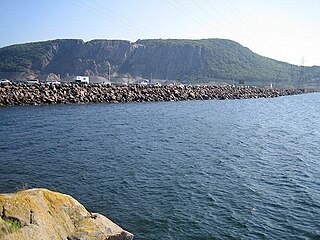
The Canso Causeway is a 1,385 m (4,544 ft) rock-fill causeway crossing the Strait of Canso, connecting Cape Breton Island by road to the Nova Scotia peninsula. Its crest thickness is 40 m (130 ft), carrying the two vehicle traffic lanes of the Trans-Canada Highway, Nova Scotia Highway 104 on the mainland side, and Nova Scotia Highway 105 on the Cape Breton side, as well as the single track mainline of the Cape Breton and Central Nova Scotia Railway.
Boularderie Island is an island separating the Cabot Strait from Bras d'Or Lake on the eastern coast of Cape Breton Island, Nova Scotia, Canada. It takes its name from Louis-Simon le Poupet de la Boularderie, who was granted the area as a concession from the King of France.

Big Pond(Scottish Gaelic: Am Pòn Mòr) is a community in the Cape Breton Regional Municipality, Nova Scotia, Canada on the south shore of Bras d'Or Lake. Big Pond is approximately in the centre between the communities of St. Peters, Nova Scotia and Sydney, Nova Scotia.
Florence is a community in the Cape Breton Regional Municipality, Nova Scotia, Canada. The community is located north of Highway 105 and west of Sydney Mines.
The Fleur-de-lis Trail is a scenic roadway located on Nova Scotia's Cape Breton Island. It is approximately 182 km (113 mi) long and runs along the southeastern part of the island through an Acadian region, with a 35 km (22 mi) spur route to and encircling Isle Madame, for a total distance of 217 km (135 mi).

Meat Cove is a rural fishing community at the northern tip of Inverness County on Nova Scotia's Cape Breton Island.
L'Ardoise is a small community located on Nova Scotia Route 247 in Richmond County on Cape Breton Island, in Nova Scotia, Canada.

Holy Angels was an all-girls high school located in Sydney, Nova Scotia, Canada. It was founded in 1885 by the Sisters of the Congregation of Notre Dame. They bestowed the school with the Latin motto: Angelis Suis Mandavit De Te meaning "He has entrusted you to the care of his angels".
Catalone is a community in the Canadian province of Nova Scotia, located in the Cape Breton Regional Municipality on Cape Breton Island.
Howie Centre is a community in the Canadian province of Nova Scotia, located in the Cape Breton Regional Municipality on Cape Breton Island. The community has a school, Mountainview Elementary, which is a complex with East Bay Elementary.
Enon is a community in the Canadian province of Nova Scotia, located in the Cape Breton Regional Municipality on Cape Breton Island.
Middle Cape is a community in the Canadian province of Nova Scotia, located in the Cape Breton Regional Municipality on Cape Breton Island.
Salem Road is a community in the Canadian province of Nova Scotia, located in the Cape Breton Regional Municipality on Cape Breton Island.
Salmon River Road is a community in the Canadian province of Nova Scotia, located in the Cape Breton Regional Municipality on Cape Breton Island.
Northside East Bay is a community in the Canadian province of Nova Scotia, located in the Cape Breton Regional Municipality on Cape Breton Island. The location of Northside East Bay is flawed on the current map. Northside East Bay is actually located on the most Easterly end of the Bras d'or Lakes; about 15 miles west of the city of Sydney.

Rankin School of the Narrows is a Primary through Grade 12 school located in Iona, Nova Scotia, Canada, on Cape Breton Island in Victoria County. It is governed by the Cape Breton – Victoria Regional School Board.
Baddeck Academy is a Primary through Grade 12 school located in Baddeck, Nova Scotia, Canada, on Cape Breton Island in Victoria County. It is governed by the Cape Breton – Victoria Regional School Board. The Academy overlooks Bras d'Or Lake.

The Victoria County Court House is a historic building in Baddeck, Nova Scotia.
Coordinates: 45°48′42.09″N60°17′32.83″W / 45.8116917°N 60.2924528°W
| | This Cape Breton County, Nova Scotia location article is a stub. You can help Wikipedia by expanding it. |