Wading River (New Jersey)

Last updated

The Wading River is a tributary of the Mullica River, approximately 10.1 miles (16.3 km) long, [1] in southern New Jersey in the United States. The river drains a rural forested area of the Pinelands, one of the most pristine areas along the coast of the northeastern United States.

Tributary stream or river that flows into a main stem river or lake

A tributary or affluent is a stream or river that flows into a larger stream or main stem river or a lake. A tributary does not flow directly into a sea or ocean. Tributaries and the main stem river drain the surrounding drainage basin of its surface water and groundwater, leading the water out into an ocean.

Mullica River river in the United States of America

The Mullica River is a 50.6-mile-long (81.4 km) river in southern New Jersey in the United States. The Mullica was once known as the Little Egg Harbor River.

New Jersey State of the United States of America

New Jersey is a state in the Mid-Atlantic and Northeastern regions of the United States. It is located on a peninsula, bordered on the north and east by the state of New York, particularly along the extent of the length of New York City on its western edge; on the east, southeast, and south by the Atlantic Ocean; on the west by the Delaware River and Pennsylvania; and on the southwest by the Delaware Bay and Delaware. New Jersey is the fourth-smallest state by area but the 11th-most populous, with 9 million residents as of 2017, and the most densely populated of the 50 U.S. states; its biggest city is Newark. New Jersey lies completely within the combined statistical areas of New York City and Philadelphia. New Jersey was the second-wealthiest U.S. state by median household income as of 2017.

Contents

Course

The primary source of the Wading River is its 22.7-mile-long (36.5 km) West Branch, [1] which rises north of Chatsworth in central Burlington County, south of Brendan T. Byrne State Forest, and flows generally south through Wharton State Forest. It joins the Oswego River near Harrisville to form the main stem of the Wading River. The Wading flows southeast and joins the Mullica River from the north near its mouth, approximately 10 miles (16 km) north of Atlantic City. The lower 3 miles (5 km) of the river forms a navigable estuary, an arm of the estuary of the Mullica, just west of the Garden State Parkway.

Chatsworth, New Jersey Unincorporated community in New Jersey, United States

Chatsworth is an unincorporated community located within Woodland Township in Burlington County, New Jersey, United States. The area is served as United States Postal Service ZIP Code 08019. The New Jersey Central's Blue Comet passenger train wrecked here in 1939.

Burlington County, New Jersey County in the United States

Burlington County is a county located in the U.S. state of New Jersey. The county is the second largest in New Jersey by total area behind Ocean County which has a total area of 915.40 sq mi and its county seat is Mount Holly. As of the 2017 Census Bureau estimate, the county's population was 448,596, making it the 11th-largest of the state's 21 counties, representing a 0.1% decrease from the 2010 United States Census, when the population was enumerated at 448,734, in turn an increase of 25,340 (6.0%) from the 423,394 enumerated in the 2000 Census. The most-populous place was Evesham Township, with 45,538 residents at the time of the 2010 Census, while Washington Township covered 102.71 square miles (266.0 km2), the largest total area of any municipality in Burlington County.

Brendan T. Byrne State Forest

The Brendan T. Byrne State Forest is a 37,242 acres (150.71 km2) state forest in the New Jersey Pine Barrens. Its protected acreage is split between Burlington and Ocean Counties.

Like the Mullica, the river is noted for its extensive wetlands, including large runs of striped bass.

Striped bass species of fish

The striped bass, also called Atlantic striped bass, striper, linesider, rock or rockfish, is an anadromous Perciforme fish of the family Moronidae found primarily along the Atlantic coast of North America. It has also been widely introduced into inland recreational fisheries across the United States. Striped bass found in the Gulf of Mexico are a separate strain referred to as Gulf Coast striped bass.

Tributaries

Oswego River (New Jersey) river in New Jersey, United States

The Oswego River is a 23.7-mile-long (38.1 km) tributary of the Wading River in the southern New Jersey Pine Barrens in the United States.

Tulpehocken Creek is a 7.7-mile-long (12.4 km) tributary of the Wading River in Burlington County in the southern New Jersey Pine Barrens in the United States.

The West Branch Wading River is a 22.7-mile-long (36.5 km) tributary of the Wading River in Burlington County in the southern New Jersey Pine Barrens in the United States.

See also

Related Research Articles

Toms River freshwater river and estuary in Ocean County, New Jersey in the United States

The Toms River is a 41.7-mile-long (67.1 km) freshwater river and estuary in Ocean County, New Jersey in the United States.

The Bass River is a 4.7-mile-long (7.6 km) tributary of the Mullica River in southeastern New Jersey in the United States.

Great Egg Harbor River

The Great Egg Harbor River is a 55.0-mile-long (88.5 km) river in southern New Jersey in the United States. It is one of the major rivers that traverse the largely pristine Pinelands, draining 308 square miles (800 km2) of wetlands into the Atlantic Ocean at Great Egg Harbor, from which it takes its name.

Tuckahoe River (New Jersey) river in the United States of America

The Tuckahoe River is a 27.6-mile-long (44.4 km) blackwater river in southern New Jersey in the United States.

Manumuskin River river in the United States of America

The Manumuskin River is a 16.3-mile-long (26.2 km) tributary of the Maurice River in Cumberland County, New Jersey in the United States.

Cohansey River river in the United States of America

The Cohansey River is a 30.6-mile-long (49.2 km) river in southern New Jersey in the United States. The river drains approximately 108 square miles (280 km2) of rural agricultural and forested lowlands on the north shore of Delaware Bay.

Rancocas Creek tributary of the Delaware River in southern New Jersey

Rancocas Creek is a tributary of the Delaware River in southwestern New Jersey in the United States. The creek's main stem is 8.3 miles (13.4 km) long, with a North Branch of 28.3 miles (45.5 km) and a South Branch flowing 21.7 miles (34.9 km). The creek system drains a rural agricultural and forested area on the western edge of the Pinelands north and northeast of Camden and the New Jersey suburbs of Philadelphia.

Feather River river in the United States of America

The Feather River is the principal tributary of the Sacramento River, in the Sacramento Valley of Northern California. The river's main stem is about 73 miles (117 km) long. Its length to its most distant headwater tributary is just over 210 miles (340 km). The main stem Feather River begins in Lake Oroville, where its four long tributary forks join together—the South Fork, Middle Fork, North Fork, and West Branch Feather Rivers. These and other tributaries drain part of the northern Sierra Nevada, and the extreme southern Cascades, as well as a small portion of the Sacramento Valley. The total drainage basin is about 6,200 square miles (16,000 km2), with approximately 3,604 square miles (9,330 km2) above Lake Oroville.

Raccoon Creek is a 22.6-mile-long (36.4 km) tributary of the Delaware River in southern New Jersey in the United States.

Landing Creek is an 11.2-mile-long (18.0 km) tributary of the Mullica River in southern New Jersey in the United States. The creek originates near Egg Harbor City and joins the Mullica River just below Lower Bank near Hog Islands. It is joined along its route by Union Creek, Indian Cabin Creek, Elliot's Creek, and Rubin's Run, respectively.

Nescochague Creek is a 6.4-mile-long (10.3 km) tributary of the Mullica River in southern New Jersey in the United States. The creek starts just northwest of Hammonton, arcs along the southern boundary of Wharton State Forest, and joins the Mullica River just above County Route 542.

Batsto River river in the United States of America

The Batsto River is a 22.9-mile-long (36.9 km) tributary of the Mullica River in the southern New Jersey Pine Barrens in the United States. The river also drains 49.42 square miles of land.

Manantico Creek, spelled Menantico on federal maps, is an 11.1-mile-long (17.9 km) tributary of the Maurice River in Cumberland County, New Jersey in the United States.

Turtle Creek is a 1.9-mile-long (3.1 km) tributary of the Mullica River in southern New Jersey in the United States.

Ballanger Creek is a 4.7-mile-long (7.6 km) tributary of the Mullica River in southern New Jersey in the United States. The name is derived from "Belangee," a family of French Huguenots who were early settlers in the area.

Jacques Cousteau National Estuarine Research Reserve

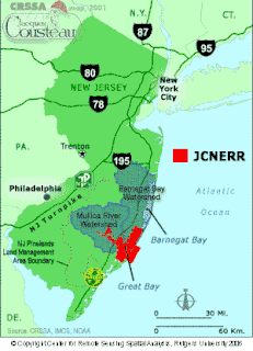
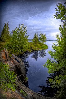
The Jacques Cousteau National Estuarine Research Reserve, located in southeastern New Jersey, encompasses over 110,000 acres (450 km²) of terrestrial, wetland and aquatic habitats within the Mullica River-Great Bay Ecosystem.

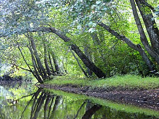
Great Bay is located in southern New Jersey's Atlantic Coastal Plain in Ocean and Atlantic Counties, about ten miles (16 km) north of Atlantic City and 87 mi (140 km) south of New York City. The Mullica River flows into the bay, and together they form the Mullica River - Great Bay estuary habitat. The bay is connected to the Atlantic Ocean via the Little Egg Inlet. Great Bay is considered one of the least-disturbed marine wetlands habitats in the northeastern United States.

References

  1. 1 2 U.S. Geological Survey. National Hydrography Dataset high-resolution flowline data. The National Map, accessed April 1, 2011

Coordinates: 39°37′10″N74°29′33″W / 39.619576°N 74.492439°W / 39.619576; -74.492439

Geographic coordinate system Coordinate system

A geographic coordinate system is a coordinate system that enables every location on Earth to be specified by a set of numbers, letters or symbols. The coordinates are often chosen such that one of the numbers represents a vertical position and two or three of the numbers represent a horizontal position; alternatively, a geographic position may be expressed in a combined three-dimensional Cartesian vector. A common choice of coordinates is latitude, longitude and elevation. To specify a location on a plane requires a map projection.