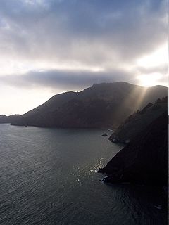
The Marin Headlands is a hilly peninsula at the southernmost end of Marin County, California, United States, located just north of San Francisco across the Golden Gate Bridge, which connects the two counties and peninsulas. The entire area is part of the Golden Gate National Recreation Area. The Headlands are famous for their views of the Bay Area, especially of the Golden Gate Bridge.

McCovey Cove is the unofficial name of a section of San Francisco Bay beyond the right field wall of Oracle Park, home of the San Francisco Giants, named after famed Giants first baseman Willie McCovey. The proper name for the cove is China Basin, which is the mouth of Mission Creek as it meets the bay. The cove is bounded along the north by Oracle Park, with a ferry landing and a breakwater at the northeast end. The southern shore is lined by China Basin Park and McCovey Point. To the east, it opens up to San Francisco Bay, while the west end of the cove is bounded by the Lefty O'Doul Bridge, named after San Francisco ballplayer and manager Lefty O'Doul.

Duboce Park is a small urban park located between the Duboce Triangle and Lower Haight neighborhoods of San Francisco, California. The park is less than one block wide from north to south and two blocks wide from west to east. Its western boundary is Scott Street, and its eastern boundary is Steiner Street. The park is part of the Duboce Park Landmark District.

Point Richmond, also sometimes referred to locally as The Point, is a neighborhood in Richmond, California, United States, near the eastern end of the Richmond-San Rafael Bridge, between Interstate 580 and the San Francisco Bay.

The Port of San Francisco is a semi-independent organization that oversees the port facilities at San Francisco, California, United States. It is run by a five-member commission, appointed by the Mayor and approved by the Board of Supervisors. The Port is responsible for managing the larger waterfront area that extends from the anchorage of the Golden Gate Bridge, along the Marina district, all the way around the north and east shores of the city of San Francisco including Fisherman's Wharf and the Embarcadero, and southward to the city line just beyond Candlestick Point. In 1968 the State of California, via the California State Lands Commission for the State-operated San Francisco Port Authority, transferred its responsibilities for the Harbor of San Francisco waterfront to the City and County of San Francisco / San Francisco Harbor Commission through the Burton Act AB2649. All eligible State port authority employees had the option to become employees of the City and County of San Francisco to maintain consistent operation of the Port of San Francisco.
India Basin is the easternmost neighborhood of San Francisco, California.

Dogpatch is a neighborhood in San Francisco, California, roughly half industrial and half residential. It was initially a gritty working-class neighborhood, but has experienced rapid transformation since the 1990s. Now it boasts similar demographics to its neighboring Potrero Hill – an upper middle-class working professional neighborhood.

Rincon Hill is a neighborhood in San Francisco, California. It is one of San Francisco's 49 hills, and one of its original "Seven Hills." The relatively compact neighborhood is bounded by Folsom Street to the north, the Embarcadero to the east, Bryant Street on the south, and Essex Street to the west. Rincon Hill is located just south of the Transbay development area, part of the greater South of Market area. The hill is about 100 feet tall.

Brickyard Cove is an upscale waterfront neighborhood in Richmond, California.
Castro Cove is an embayment of the San Pablo Bay in Richmond, California between Point San Pablo and the confluence of Wildcat Creek into Castro Creek.
Stege Marsh, also known as the South Richmond Marshes, is a tidal marshland wetlands area in Richmond, California in western Contra Costa County.
The Raccoon Strait is a waterway of the San Francisco Bay between Angel Island and the Tiburon Peninsula, mainland Marin County, California. During the ice ages, when sea levels were considerably lower and San Francisco Bay was a grassy valley, the combined Sacramento-San Joaquin river flowed through what is now Raccoon Strait before flowing through the canyon at the Golden Gate.
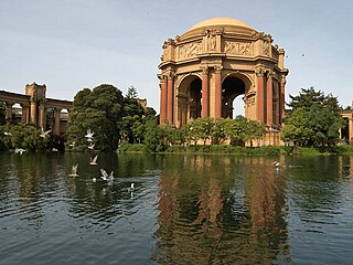
The Marina District is a neighborhood located in San Francisco, California. The neighborhood sits on the site of the 1915 Panama–Pacific International Exposition, staged after the 1906 San Francisco earthquake to celebrate the reemergence of the city. Aside from the Palace of Fine Arts (POFA), all other buildings were demolished to make the current neighborhood. The Marina currently has the highest non-Hispanic white resident percentage of any recognized neighborhood in San Francisco.

Pier 70 in San Francisco, California, is a historic pier in San Francisco's Potrero Point neighborhood, home to the Union Iron Works and later to Bethlehem Shipbuilding. It was one of the largest industrial sites in San Francisco during the two World Wars. Today, it is regarded as the best preserved 19th century industrial complex west of the Mississippi.

Keller Beach is a public beach on the San Francisco Bay in Richmond, California.

The Potrero Generating Station was a natural gas and diesel burning electricity generating station owned by Mirant and located on a 23-acre (9.3 ha) site in Potrero Point, San Francisco, California. The plant's primary power source was a 206 MW, natural gas burning steam turbine providing baseload power and referred to as "Unit 3". In addition, three 52 MW peaking power diesel generators provided additional power during times of highest consumption. Since the closure of the Hunters Point Power Plant in 2006, Potrero was the last remaining fossil fuel power plant within the confines of San Francisco, with capacity to provide approximately 1/3 of the City's peak electrical power needs.
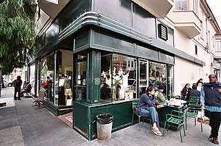
Tartine is a bakery in San Francisco, California, located in the Mission District, at 600 Guerrero Street. Writing in the New York Times, food columnist Mark Bittman called it his favorite bakery in the U.S. In 2008 its owners, Elisabeth Prueitt and Chad Robertson, won James Beard Foundation Awards as the best pastry chefs in America, after previously being nominated for this award in 2006 and 2007.

SPUR, formally known as the San Francisco Bay Area Planning and Urban Research Association, is a non-profit research, education, and advocacy organization focused on issues of planning and governance in San Francisco, San Jose and Oakland.
37°45′31.15″N122°23′10.91″W

Alcatraz water tower is on Alcatraz Island in the San Francisco Bay, off the coast of San Francisco, California. It is located on the northwestern side of the island, near Tower No. 3, beyond the Morgue and Recreation Yard. The water tank is situated on six cross-braced steel legs submerged in concrete foundations.

