Newport most commonly refers to:
Nottinghamshire is a ceremonial county in the East Midlands, England. The county borders South Yorkshire to the north-west, Lincolnshire to the east, Leicestershire to the south, and Derbyshire to the west. The largest settlement is the city of Nottingham (323,632).

Beeston is a town in the Borough of Broxtowe, Nottinghamshire, England, 3.4 miles (5.5 km) south-west of Nottingham city centre. To its north-east is the University of Nottingham's main campus, University Park. The pharmaceutical and retail chemist group Boots has its headquarters 0.6 miles (1 km) east of the centre of Beeston, on the border with Broxtowe and the City of Nottingham. To the south lie the River Trent and the village of Attenborough, with extensive wetlands.
Darton is a large village in the Metropolitan Borough of Barnsley, on the border with West Yorkshire, England. At the time of the 2001 UK census, it had a population of 14,927, increasing to 21,345 for both Darton Wards at the 2011 Census.

The Robin Hood Line is a railway line running from Nottingham to Worksop, Nottinghamshire, in England. The stations between Shirebrook and Whitwell (inclusive) are in the county of Derbyshire.

Kirkby-in-Ashfield is a market town in the Ashfield District of Nottinghamshire, England. With a population of 25,265, it is a part of the wider Mansfield Urban Area. The Head Offices of Ashfield District Council are located on Urban Road in the town centre.

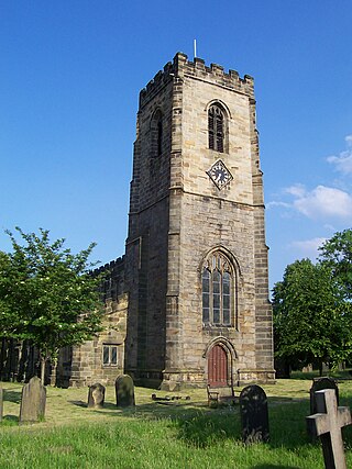
Southwell is a minster and market town in the district of Newark and Sherwood in Nottinghamshire, England. It is home to the grade-I listed Southwell Minster, the cathedral of the Anglican Diocese of Southwell and Nottingham. The population of the town was recorded at 7,558 in the 2021 Census. The town is on the River Greet and is located geographically 9 miles (14 km) west of Newark on Trent, 15 miles (24 km) north-east of Nottingham, 13 miles (21 km) south-east of Mansfield and 22 miles (35 km) south-east of Worksop.
Redmile is an English village and civil parish in the Melton district of Leicestershire, about ten miles (16 km) north of Melton Mowbray and seven miles (11 km) west of Grantham. The population of the civil parish, which includes Barkestone-le-Vale and Plungar, was 921 at the 2011 census, up from 829 in 2001.
Wilford is a village in the city of Nottingham, Nottinghamshire, England. The village is to the northeast of Clifton, southwest of West Bridgford, northwest of Ruddington and southwest of Nottingham city centre. It is at a meander of the River Trent.
Thomas Warsop was an English cricketer who played a single match of first-class cricket for a combined Nottinghamshire and Leicestershire side in 1803.
Richard Warsop was an English professional cricketer who played in two first-class cricket matches.
Warsop is a town and civil parish in Mansfield District, Nottinghamshire, England, on the outskirts of the remnants of Sherwood Forest. At the 2001 census it had a population of 12,365, reducing to 11,999 at the 2011 Census including Church Warsop, Meden Vale, Sookholme and Spion Kop.

Mansfield is a market town and the administrative centre of the Mansfield District in Nottinghamshire, England. It is the largest town in the wider Mansfield Urban Area and the second largest settlement in Nottinghamshire. It gained the Royal Charter of a market town in 1227. The town lies in the Maun Valley, 12 miles (19 km) north of Nottingham. It had a population of 110,500 at the 2021 census, according to the Office for National Statistics. Mansfield is the one local authority in Nottinghamshire with a publicly elected mayor.

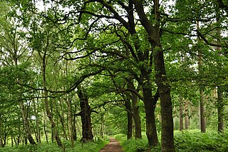
Kings Clipstone is a settlement and civil parish, in the Newark and Sherwood district, in the county of Nottinghamshire, England. The parish lies in the west of the county, and north west within the district. It is 122 miles north of London, 15 miles north of the city of Nottingham, and 5 miles north east of the market town of Mansfield. In 2011 the parish had a population of 318. The parish touches Clipstone village, Edwinstowe, Rufford and Warsop. The parish was formerly part of the wider Clipstone parish, on 1 April 2011 it became a separate parish. The area is within Sherwood Forest, well known for the Robin Hood legend.

Sookholme is a village and former civil parish, now in the parish of Warsop in the Mansfield district of western Nottinghamshire, England. It is 120 miles (190 km) north west of London, 16+3⁄4 miles (27.0 km) north of the county town and city of Nottingham, and 3+1⁄2 miles (5.6 km) north of the town of Mansfield. It retains an agricultural character, having been largely unaffected by the Industrial Revolution, which had a transformative impact on the settlement pattern and built form of numerous other settlements situated within the North Midlands coalfields. Whilst relatively close to the built up areas of Mansfield and Shirebrook, Sookholme is remote and rural. In 1931 the parish had a population of 210.

Warsop Vale is a small village in the Mansfield district of western Nottinghamshire, England. It is 120 miles (190 km) north west of London, 17+1⁄2 miles (28.2 km) north of the county town and city of Nottingham, and 4+1⁄4 miles (6.8 km) north of the town of Mansfield. It is in the civil parish of Warsop. Warsop Vale's heritage is primarily as a former mining village. It lies in the very picturesque area known as the Dukeries and is easily accessible to Clumber Park, Thoresby Park and hall, Rufford Park and the Earl of Portland estate of Welbeck, together all part of Sherwood Forest.