
North Atlantic Deep Water (NADW) is a deep water mass formed in the North Atlantic Ocean. Thermohaline circulation of the world's oceans involves the flow of warm surface waters from the southern hemisphere into the North Atlantic. Water flowing northward becomes modified through evaporation and mixing with other water masses, leading to increased salinity. When this water reaches the North Atlantic it cools and sinks through convection, due to its decreased temperature and increased salinity resulting in increased density. NADW is the outflow of this thick deep layer, which can be detected by its high salinity, high oxygen content, nutrient minima, high 14C/12C, and chlorofluorocarbons (CFCs).

Salinity is the saltiness or amount of salt dissolved in a body of water, called saline water. It is usually measured in g/L or g/kg.

An ocean current is a continuous, directed movement of seawater generated by a number of forces acting upon the water, including wind, the Coriolis effect, breaking waves, cabbeling, and temperature and salinity differences. Depth contours, shoreline configurations, and interactions with other currents influence a current's direction and strength. Ocean currents are primarily horizontal water movements.

Physical oceanography is the study of physical conditions and physical processes within the ocean, especially the motions and physical properties of ocean waters.

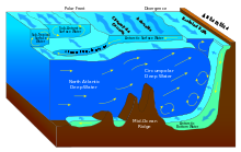
Thermohaline circulation (THC) is a part of the large-scale ocean circulation that is driven by global density gradients created by surface heat and freshwater fluxes. The adjective thermohaline derives from thermo- referring to temperature and -haline referring to salt content, factors which together determine the density of sea water. Wind-driven surface currents travel polewards from the equatorial Atlantic Ocean, cooling en route, and eventually sinking at high latitudes. This dense water then flows into the ocean basins. While the bulk of it upwells in the Southern Ocean, the oldest waters upwell in the North Pacific. Extensive mixing therefore takes place between the ocean basins, reducing differences between them and making the Earth's oceans a global system. The water in these circuits transport both energy and mass around the globe. As such, the state of the circulation has a large impact on the climate of the Earth.

The East Greenland Current (EGC) is a cold, low-salinity current that extends from Fram Strait (~80N) to Cape Farewell (~60N). The current is located off the eastern coast of Greenland along the Greenland continental margin. The current cuts through the Nordic Seas and through the Denmark Strait. The current is of major importance because it directly connects the Arctic to the Northern Atlantic, it is a major contributor to sea ice export out of the Arctic, and it is a major freshwater sink for the Arctic.
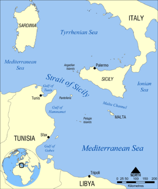
The Strait of Sicily is the strait between Sicily and Tunisia. The strait is about 145 kilometres (90 mi) wide and divides the Tyrrhenian Sea and the western Mediterranean Sea, from the eastern Mediterranean Sea. The maximum depth is 316 meters (1,037 ft). The island of Pantelleria lies in the middle of the strait.

The Norwegian Current is one of two dominant arctic inflows of water. It can be traced from near Shetland, north of Scotland, otherwise from the eastern North Sea at depths of up to 100 metres. It finally passes the opening into the Barents Sea, a large outcrop of the Arctic Ocean. Compared to its partial source the North Atlantic Current it is colder and less salty; the other sources are the less saline North and Baltic seas and the Norwegian fjords and rivers. It is considerably warmer and saltier than the Arctic Ocean, which is freshened by precipitation and ice in and around it. Winter temperatures in the flow are typically between 2 and 5 °C — the co-parent North Atlantic flow, a heat remnant of its Gulf Stream chief contributor, exceeds 6 °C.
The environmental isotopes are a subset of isotopes, both stable and radioactive, which are the object of isotope geochemistry. They are primarily used as tracers to see how things move around within the ocean-atmosphere system, within terrestrial biomes, within the Earth's surface, and between these broad domains.

The Antarctic bottom water (AABW) is a type of water mass in the Southern Ocean surrounding Antarctica with temperatures ranging from −0.8 to 2 °C (35 °F) and absolute salinities from 34.6 to 35.0 g/kg. As the densest water mass of the oceans, AABW is found to occupy the depth range below 4000 m of all ocean basins that have a connection to the Southern Ocean at that level. AABW forms the lower branch of the large-scale movement in the world's oceans through thermohaline circulation.
A subtropical front is a surface water mass boundary or front, which is a narrow zone of transition between air masses of contrasting density, air masses of different temperatures or different water vapour concentrates. It is also characterized by an unforeseen change in wind direction, and speed across its surface between water systems, which are based on temperature and salinity. The subtropical separates the more saline subtropical waters from the fresher sub-Antarctic waters.
Bottom water is the lowermost water mass in a water body, by its bottom, with distinct characteristics, in terms of physics, chemistry, and ecology.
Antarctic Intermediate Water (AAIW) is a cold, relatively low salinity water mass found mostly at intermediate depths in the Southern Ocean. The AAIW is formed at the ocean surface in the Antarctic Convergence zone or more commonly called the Antarctic Polar Front zone. This convergence zone is normally located between 50°S and 60°S, hence this is where almost all of the AAIW is formed.

The West Spitsbergen Current (WSC) is a warm, salty current that runs poleward just west of Spitsbergen,, in the Arctic Ocean. The WSC branches off the Norwegian Atlantic Current in the Norwegian Sea. The WSC is of importance because it drives warm and salty Atlantic Water into the interior Arctic. The warm and salty WSC flows north through the eastern side of Fram Strait, while the East Greenland Current (EGC) flows south through the western side of Fram Strait. The EGC is characterized by being very cold and low in salinity, but above all else it is a major exporter of Arctic sea ice. Thus, the EGC combined with the warm WSC makes the Fram Strait the northernmost ocean area having ice-free conditions throughout the year in all of the global ocean.
In oceanography, a front is a boundary between two distinct water masses. The formation of fronts depends on multiple physical processes and small differences in these lead to a wide range of front types. They can be as narrow as a few hundreds of metres and as wide as several tens of kilometres. While most fronts form and dissipate relatively quickly, some can persist for long periods of time.
Circumpolar Deep Water (CDW) is a designation given to the water mass in the Pacific and Indian oceans that is a mixing of other water masses in the region. It is characteristically warmer and saltier than the surrounding water masses, causing CDW to contribute to the melting of ice shelves in the Antarctic region.
Brine rejection is a process that occurs when salty water freezes. The salts do not fit in the crystal structure of water ice, so the salt is expelled.
Labrador Sea Water is an intermediate water mass characterized by cold water, relatively low salinity compared to other intermediate water masses, and high concentrations of both oxygen and anthropogenic tracers. It is formed by convective processes in the Labrador Sea located between Greenland and the northeast coast of the Labrador Peninsula. Deep convection in the Labrador Sea allows colder water to sink forming this water mass, which is a contributor to the upper layer of North Atlantic Deep Water. North Atlantic Deep Water flowing southward is integral to the Atlantic Meridional Overturning Circulation. The Labrador Sea experiences a net heat loss to the atmosphere annually.
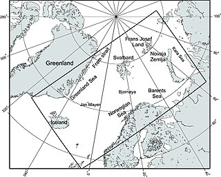
The Nordic Seas are located north of Iceland and south of Svalbard. They have also been defined as the region located north of the Greenland-Scotland Ridge and south of the Fram Strait-Spitsbergen-Norway intersection. Known to connect the North Pacific and the North Atlantic waters, this region is also known as having some of the densest waters, creating the densest region found in the North Atlantic Deep Water. The deepest waters of the Arctic Ocean are connected to the worlds other oceans through Nordic Seas and Fram Strait. There are three seas within the Nordic Sea: Greenland Sea, Norwegian Sea, and Iceland Sea. The Nordic Seas only make up about 0.75% of the World's Oceans. This region is known as having diverse features in such a small topographic area, such as the mid oceanic ridge systems. Some locations have shallow shelves, while others have deep slopes and basins. This region, because of the atmosphere-ocean transfer of energy and gases, has varying seasonal climate. During the winter, sea ice is formed in the western and northern regions of the Nordic Seas, whereas during the summer months, the majority of the region remains free of ice.

Stratification in water is the formation in a body of water of relatively distinct and stable layers by density. It occurs in all water bodies where there is stable density variation with depth. Stratification is a barrier to the vertical mixing of water, which affects the exchange of heat, carbon, oxygen and nutrients. Wind-driven upwelling and downwelling of open water can induce mixing of different layers through the stratification, and force the rise of denser cold, nutrient-rich, or saline water and the sinking of lighter warm or fresher water, respectively. Layers are based on water density: denser water remains below less dense water in stable stratification in the absence of forced mixing.

