The Water of Leith is the main river flowing through Edinburgh, Scotland, to the port of Leith where it flows into the sea via the Firth of Forth.
The Avon is a river largely in the Falkirk council area of Scotland.

The River Ness is a river about 6 miles or 10km long, which flows from the northern end of Loch Ness in Scotland, through Loch Dochfour, north-east to Inverness, with a total fall in height of about 16 metres before discharging into the Beauly Firth. The river is the origin of the name of Inverness which is from the Scottish Gaelic: Inbhir Nis, meaning "Mouth of the Ness".
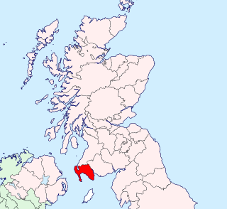
Wigtownshire or the County of Wigtown is a historic county, registration county and lieutenancy area in south-west Scotland. Until 1975, Wigtownshire was one of the administrative counties used for local government purposes, and is now administered as part of the council area of Dumfries and Galloway. As a lieutenancy area, Wigtownshire has its own Lord Lieutenant, currently John Alexander Ross. In the 19th century, it was also called West Galloway. The county town was historically Wigtown, with the administrative centre moving to Stranraer, the largest town, on the creation of a county council in 1890.

The River Moy is a river in the northwest of Ireland.

The River Erne in the northwest of the island of Ireland, is the second-longest river in Ulster flowing through Northern Ireland and the Republic of Ireland. It rises on the east shoulder of Slieve Glah mountain three miles south of Cavan in County Cavan, Republic of Ireland, and flows 80 miles (129 km) through Lough Gowna, Lough Oughter and Upper and Lower Lough Erne, County Fermanagh, Northern Ireland, to the sea at Ballyshannon, County Donegal back in the Republic. For 30 miles from Crossdoney in County Cavan to Enniskillen in County Fermanagh, it is difficult to distinguish the river as it winds its way through interconnected loughs or parts of loughs nestling among the drumlin hills of Cavan and south Fermanagh. The river is 120 kilometres long and is used for fly fishing for trout and salmon, with a number of fisheries along both the river itself and its tributaries. The town of Enniskillen is mostly situated on an island in the river, between Upper and Lower Lough Erne. It is linked to the River Shannon by the Shannon–Erne Waterway. The total catchment area of the River Erne is 4,372 km2. The long-term average flow rate of the River Erne is 101.7 cubic metres per second (m3/s)

The Machars is a peninsula in the historical county of Wigtownshire in Galloway in the south-west of Scotland. The word is derived from the Gaelic word Machair meaning low-lying or level land, known as "links" on the east coast of Scotland. Although there are no high peaks in the Machars, it is not flat and would best be described as undulating or rolling. The North Atlantic Drift or Gulf Stream creates a mild climate, and dolphins and basking sharks are frequently seen in the seas.

Glenluce Abbey, near to Glenluce, Scotland, was a Cistercian monastery called also Abbey of Luce or Vallis Lucis and founded around 1190 by Rolland or Lochlann, Lord of Galloway and Constable of Scotland. Following the Scottish Reformation in 1560, the abbey fell into disuse.

The Bladnoch is a river in Wigtownshire in the Machars of Galloway in southwest Scotland. One of the earliest descriptions of it is given by Sir Andrew Agnew of Lochnaw and Sir David Dunbar in an appendix to Andrew Symson's work "A Large Description of Galloway" written in the 17th century. In this they state that:
Blaidzenoch which floweth from the mountnous parts of Penninghame, and runs from the north to the south. It runneth through Lochmabary, and by the way it receaveth into several waters; the most considerable is the water of Tarfe, which hath its rise from Airtfeeld, in the Muirs of Luce, and falleth into Blaidzenoch, under the house of Craighlaw. The Blaidzenoch turns to the east, and after it heth fra its source run twenty miles (32 km), it falleth into the Bay of Wigtown, near above the place of Baldone.

New Luce is a civil parish in Dumfries and Galloway, south-west Scotland. It lies in the traditional county of Wigtownshire, and is about 10 miles (16 km) in length and 5 miles (8.0 km) in breath, being the upper part of the original Glenluce Parish. New Luce is shown as a civil parish on John Ainslie's county map of 1782.

The River Teith is a river in Scotland, which is formed from the confluence of two smaller rivers, the Garbh Uisge and Eas Gobhain at Callander, Stirlingshire. It flows into the River Forth near Drip north-west of Stirling.

Clan MacDowall is a Lowlands Scottish clan.
Urr Water or River Urr is a river in which flows through the counties of Dumfriesshire and Kirkcudbrightshire in southwest Scotland.

The River Cree is a river in Dumfries and Galloway, Scotland which runs through Newton Stewart and into the Solway Firth. It forms part of the boundary between the counties of Wigtownshire and Kirkcudbrightshire. The tributaries of the Cree are the Minnoch, Trool, Penkiln and Palnure which drain from the Range of the Awful Hand, the labyrinthine range of mountains and lochs, bogs, burns and crags, rising at its highest to The Merrick, Galloway, 12 miles to the north and visible from Newton Stewart.

The Castle of Park is a 16th-century L-plan tower house near Glenluce, in the historic county of Wigtownshire in Dumfries and Galloway, Scotland. It is a category A listed building.

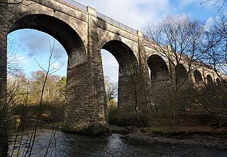
The Tarf Water is a river in the former county of Wigtownshire in south-west Scotland. It rises on the Ayrshire border (55.0048°N 4.7815°W) and flows in a generally southeastward direction to meet the River Bladnoch near the village of Kirkcowan (54.9103°N 4.5792°W). It has no major tributaries but is fed by numerous burns which drain an area characterised by drumlins and much of which has been afforested.
Old Luce is a civil parish in Dumfries and Galloway, Scotland. It lies in the Machars peninsula, in the traditional county of Wigtownshire. The parish is around 10 miles (16 km) long and 8 miles (13 km) broad, and contains 40,350 acres (16,330 ha).