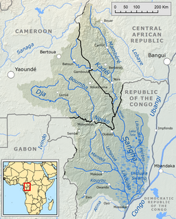
The Sangha River, a tributary of the Congo River, is located in Central Africa.
The Logon or Logone River is a major tributary of the Chari River. The Logone's sources are located in the western Central African Republic, northern Cameroon, and southern Chad. It has two major tributaries. The Pendé River in the prefecture Ouham-Pendé in the Central African Republic and the Mbéré River at the east of Cameroon. Many swamps and wetlands surround the river.

The Far North Region, also known as the Extreme North Region, is the northernmost constituent province of the Republic of Cameroon. It borders the North Region to the south, Chad to the east, and Nigeria to the west. The capital is Maroua.

Waza National Park is a national park in the Department of Logone-et-Chari, in Far North Region, Cameroon. It was founded in 1934 as a hunting reserve, and covers a total of 1,700 square kilometres (660 sq mi). Waza achieved national park status in 1968, and became a UNESCO biosphere reserve in 1979.
El Yali National Reserve is a nature reserve of Chile located in the southern portion of the Valparaíso Region. This coastal wetland is a Ramsar site and covers an area of 5.2 km².

Hay-Zama Lakes is a 586-square-kilometre (226 sq mi) inland wetland and wildland park in northwestern Alberta, Canada. It was designated a Ramsar wetland of international importance on May 24, 1982, and is recognized as an Important Bird Area. It "constitutes one of the most extensive sedge wetlands in western North America".

Logone-et-Chari is a department of Extreme-Nord Province in Cameroon. The department covers an area of 12,133 km² and at the 2005 Census had a total population of 486,997. The capital of the department is at Kousseri.

The Ord River floodplain is the floodplain of the lower Ord River in the Shire of Wyndham-East Kimberley, in the Kimberley region of northern Western Australia. It lies within the Victoria Bonaparte IBRA bioregion and contains river, seasonal creek, tidal mudflat and floodplain wetlands, with extensive stands of mangroves, that support saltwater crocodiles and many waterbirds. It is recognised as an internationally important wetland area, with 1,384 km2 of it designated on 7 June 1990 as Ramsar Site 477 under the Ramsar Convention on Wetlands.

The Chad Basin National Park is a national park in northeastern Nigeria, in the Chad Basin, with a total area of about 2,258 km2. The park is fragmented, with three sectors. The Chingurmi-Duguma sector is in Borno State, in a Sudanian Savanna ecological zone. The Bade-Nguru Wetlands and Bulatura sectors are in Yobe State in the Sahel ecological zone.

Banrock Station Wetland Complex is a wetland complex located in South Australia which has been recognised as being of international importance by designation under the Ramsar Convention. It was listed on 21 October 2002 as Ramsar site 1221. It lies in the Riverland region of south-eastern South Australia and is adjacent to the Murray River. It is a floodplain wetland subject to an ongoing environmental restoration program by a commercial organisation which manages the wetlands and promotes ecologically sustainable land use practices. In 2002 Banrock Station Wines received the Ramsar Wetland Conservation Award in recognition of its conservation efforts.

The Coongie Lakes is a freshwater wetland system located in the Far North region of South Australia. The 21,790-square-kilometre (8,410 sq mi) lakes system is located approximately 1,046 kilometres north of the Adelaide city centre. The wetlands includes lakes, channels, billabongs, shallow floodplains, deltas, and interdune swamps. It lies on the floodplain of Cooper Creek, an ephemeral river flowing through a desert landscape in the Lake Eyre Basin which rarely, after occasional large floods, empties into Lake Eyre. The wetland system has been recognised both as being of international importance by designation under the Ramsar Convention with a listing on 15 June 1987 and being nationally important within Australia with a listing in A Directory of Important Wetlands in Australia (DIWA). Its extent includes the regional town of Innamincka, the Malkumba-Coongie Lakes National Park, the Innamincka Regional Reserve, the Strzelecki Regional Reserve and the Coongie Lakes Important Bird Area.
The Paroo Floodplain and Currawinya Important Bird Area is a 7,874 km2 (3,040 sq mi) site comprising the floodplain and the associated wetlands of the Paroo River in north-western New South Wales and south-western Queensland, Australia. It includes extensive areas of the Paroo-Darling and Currawinya National Parks, both of which are listed under the Ramsar Convention as wetland sites of international importance, as well as of the Nocoleche Nature Reserve.

The Gwydir Wetlands comprise a system of irregularly inundated wetlands associated with the Gwydir River in the North West Slopes region of north-eastern New South Wales, Australia. When flooded they form an important site for breeding waterbirds.

Lake Opeta is a lake with an extensive wetland system in Uganda.
The Yaéré, from Fula yaayre, is the name of a vast annually flooded flat savanna grassland plain, part of the extensive floodplains around the shallow and variable Lake Chad in Central Africa.
The New South Wales Central Murray Forests lie on the floodplain of the Murray River in the Riverina region of south-central New South Wales, Australia. On 20 May 2003 the forests were recognised as a wetland site of international importance (RS1291) by designation under the Ramsar Convention on Wetlands.

The Flood Plain Lower Ringarooma River wetlands is a wetland site comprises the floodplain of the lower Ringarooma River in north-eastern Tasmania, Australia. In 1982 it was designated a wetland of international importance under the Ramsar Convention.
The Interlaken Lakeside Reserve is a wetland reserve at subalpine Interlaken, lying at the north-western end of Lake Crescent on the Interlaken isthmus between the reservoirs of Lakes Sorell and Crescent, about 20 km west of Tunbridge, in the Central Highlands of Tasmania, Australia. In 1982 it was designated a wetland of international importance under the Ramsar Convention.

Sakumono Lagoon is a coastal lagoon in Sakumono near Tema in the Greater Accra Region of Ghana, West Africa. The site covers 1,340 hectares. It was designated as Ramsar wetland site of international importance on 14 August 1992.

