
In meteorology, wind speed, or wind flow speed, is a fundamental atmospheric quantity caused by air moving from high to low pressure, usually due to changes in temperature. Wind speed is now commonly measured with an anemometer.

The National Weather Service (NWS) is an agency of the United States federal government that is tasked with providing weather forecasts, warnings of hazardous weather, and other weather-related products to organizations and the public for the purposes of protection, safety, and general information. It is a part of the National Oceanic and Atmospheric Administration (NOAA) branch of the Department of Commerce, and is headquartered in Silver Spring, Maryland, within the Washington metropolitan area. The agency was known as the United States Weather Bureau from 1891 until it adopted its current name in 1970.

Rogue waves are large and unpredictable surface waves that can be extremely dangerous to ships and isolated structures such as lighthouses. They are distinct from tsunamis, which are long wavelength waves, often almost unnoticeable in deep waters and are caused by the displacement of water due to other phenomena. A rogue wave at the shore is sometimes called a sneaker wave.

Jason-1 was a satellite altimeter oceanography mission. It sought to monitor global ocean circulation, study the ties between the ocean and the atmosphere, improve global climate forecasts and predictions, and monitor events such as El Niño and ocean eddies. Jason-1 was launched in 2001 and it was followed by OSTM/Jason-2 in 2008, and Jason-3 in 2016 – the Jason satellite series. Jason-1 was launched alongside the TIMED spacecraft.
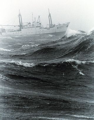
In oceanography, sea state is the general condition of the free surface on a large body of water—with respect to wind waves and swell—at a certain location and moment. A sea state is characterized by statistics, including the wave height, period, and spectrum. The sea state varies with time, as the wind and swell conditions change. The sea state can be assessed either by an experienced observer or by using instruments like weather buoys, wave radar or remote sensing satellites.
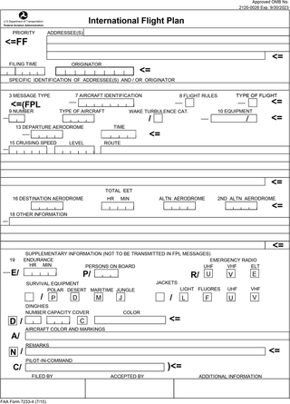
Flight plans are documents filed by a pilot or flight dispatcher with the local Air Navigation Service Provider prior to departure which indicate the plane's planned route or flight path. Flight plan format is specified in ICAO Doc 4444. They generally include basic information such as departure and arrival points, estimated time en route, alternate airports in case of bad weather, type of flight, the pilot's information, number of people on board, and information about the aircraft itself. In most countries, flight plans are required for flights under IFR, but may be optional for flying VFR unless crossing international borders. Flight plans are highly recommended, especially when flying over inhospitable areas such as water, as they provide a way of alerting rescuers if the flight is overdue. In the United States and Canada, when an aircraft is crossing the Air Defense Identification Zone (ADIZ), either an IFR or a special type of VFR flight plan called a DVFR flight plan must be filed. For IFR flights, flight plans are used by air traffic control to initiate tracking and routing services. For VFR flights, their only purpose is to provide needed information should search and rescue operations be required, or for use by air traffic control when flying in a "Special Flight Rules Area."
GRIB is a concise data format commonly used in meteorology to store historical and forecast weather data. It is standardized by the World Meteorological Organization's Commission for Basic Systems, known under number GRIB FM 92-IX, described in WMO Manual on Codes No.306. Currently there are three versions of GRIB. Version 0 was used to a limited extent by projects such as TOGA, and is no longer in operational use. The first edition is used operationally worldwide by most meteorological centers, for Numerical Weather Prediction output (NWP). A newer generation has been introduced, known as GRIB second edition, and data is slowly changing over to this format. Some of the second-generation GRIB is used for derived products distributed in the Eumetcast of Meteosat Second Generation. Another example is the NAM model.

Flight planning is the process of producing a flight plan to describe a proposed aircraft flight. It involves two safety-critical aspects: fuel calculation, to ensure that the aircraft can safely reach the destination, and compliance with air traffic control requirements, to minimise the risk of midair collision. In addition, flight planners normally wish to minimise flight cost through the appropriate choice of route, height, and speed, and by loading the minimum necessary fuel on board. Air Traffic Services (ATS) use the completed flight plan for separation of aircraft in air traffic management services, including tracking and finding lost aircraft, during search and rescue (SAR) missions.
This article describes severe weather terminology used by the National Weather Service (NWS) in the United States, a government agency operating within the Department of Commerce as an arm of the National Oceanic and Atmospheric Administration (NOAA).

A swell, also sometimes referred to as ground swell, in the context of an ocean, sea or lake, is a series of mechanical waves that propagate along the interface between water and air under the predominating influence of gravity, and thus are often referred to as surface gravity waves. These surface gravity waves have their origin as wind waves, but are the consequence of dispersion of wind waves from distant weather systems, where wind blows for a duration of time over a fetch of water, and these waves move out from the source area at speeds that are a function of wave period and length. More generally, a swell consists of wind-generated waves that are not greatly affected by the local wind at that time. Swell waves often have a relatively long wavelength, as short wavelength waves carry less energy and dissipate faster, but this varies due to the size, strength, and duration of the weather system responsible for the swell and the size of the water body, and varies from event to event, and from the same event, over time. Occasionally, swells that are longer than 700m occur as a result of the most severe storms.

Swash, or forewash in geography, is a turbulent layer of water that washes up on the beach after an incoming wave has broken. The swash action can move beach materials up and down the beach, which results in the cross-shore sediment exchange. The time-scale of swash motion varies from seconds to minutes depending on the type of beach. Greater swash generally occurs on flatter beaches. The swash motion plays the primary role in the formation of morphological features and their changes in the swash zone. The swash action also plays an important role as one of the instantaneous processes in wider coastal morphodynamics.
Surf forecasting is the process of using offshore swell data to predict onshore wave conditions. It is used by millions of people across the world, including professionals who put their forecasts online, meteorologists who work for news crews, and surfers all over the world. It is impossible to make an exact prediction of the surf, but by knowing a few factors a good prediction can be made. One needs to have an understanding of how waves are formed, a basic knowledge of bathymetry, and information about the surf spot being forecasted to accurately forecast the surf.
In physical oceanography, the significant wave height (SWH, HTSGW or Hs) is defined traditionally as the mean wave height (trough to crest) of the highest third of the waves (H1/3). It is usually defined as four times the standard deviation of the surface elevation – or equivalently as four times the square root of the zeroth-order moment (area) of the wave spectrum. The symbol Hm0 is usually used for that latter definition. The significant wave height (Hs) may thus refer to Hm0 or H1/3; the difference in magnitude between the two definitions is only a few percent. SWH is used to characterize sea state, including winds and swell.
A wind power forecast corresponds to an estimate of the expected production of one or more wind turbines in the near future, up to a year. Forecast are usually expressed in terms of the available power of the wind farm, occasionally in units of energy, indicating the power production potential over a time interval.

OSTM/Jason-2, or Ocean Surface Topography Mission/Jason-2 satellite, was an international Earth observation satellite altimeter joint mission for sea surface height measurements between NASA and CNES. It was the third satellite in a series started in 1992 by the NASA/CNES TOPEX/Poseidon mission and continued by the NASA/CNES Jason-1 mission launched in 2001.
The maximum sustained wind associated with a tropical cyclone is a common indicator of the intensity of the storm. Within a mature tropical cyclone, it is found within the eyewall at a certain distance from the center, known as the radius of maximum wind, or RMW. Unlike gusts, the value of these winds are determined via their sampling and averaging the sampled results over a period of time. Wind measuring has been standardized globally to reflect the winds at 10 metres (33 ft) above mean sea level, and the maximum sustained wind represents the highest average wind over either a one-minute (US) or ten-minute time span, anywhere within the tropical cyclone. Surface winds are highly variable due to friction between the atmosphere and the Earth's surface, as well as near hills and mountains over land.

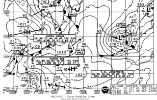
The Ocean Prediction Center (OPC), established in 1995, is one of the National Centers for Environmental Prediction's (NCEP's) original six service centers. Until 2003, the name of the organization was the Marine Prediction Center. Its origins are traced back to the sinking of the RMS Titanic in 1912. The OPC issues forecasts up to five days in advance for ocean areas north of 31° north latitude and west of 35° west longitude in the Atlantic, and across the northeast Pacific north of 30° north latitude and east of 160° east longitude. Until recently, the OPC provided forecast points for tropical cyclones north of 20° north latitude and east of the 60° west longitude to the National Hurricane Center. OPC is composed of two branches: the Ocean Forecast Branch and the Ocean Applications Branch.
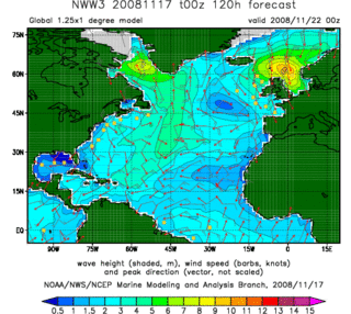
In fluid dynamics, wind wave modeling describes the effort to depict the sea state and predict the evolution of the energy of wind waves using numerical techniques. These simulations consider atmospheric wind forcing, nonlinear wave interactions, and frictional dissipation, and they output statistics describing wave heights, periods, and propagation directions for regional seas or global oceans. Such wave hindcasts and wave forecasts are extremely important for commercial interests on the high seas. For example, the shipping industry requires guidance for operational planning and tactical seakeeping purposes.

Variable renewable energy (VRE) or intermittent renewable energy sources (IRES) are renewable energy sources that are not dispatchable due to their fluctuating nature, such as wind power and solar power, as opposed to controllable renewable energy sources, such as dammed hydroelectricity or bioenergy, or relatively constant sources, such as geothermal power.
Marine weather forecasting is the process by which mariners and meteorological organizations attempt to forecast future weather conditions over the Earth's oceans. Mariners have had rules of thumb regarding the navigation around tropical cyclones for many years, dividing a storm into halves and sailing through the normally weaker and more navigable half of their circulation. Marine weather forecasts by various weather organizations can be traced back to the sinking of the Royal Charter in 1859 and the RMS Titanic in 1912.