Aurich is a district (Landkreis) in Lower Saxony, Germany. It is bounded by the North Sea, the districts of Wittmund and Leer, and the city of Emden.
Wittmund is a Landkreis (district) in the northwestern part of Lower Saxony, Germany. It is situated in East Frisia, on the North Sea coast. Neighboring districts are Friesland, Leer and Aurich.
Lüneburg is a district in Lower Saxony, Germany. It is bounded by the districts of Lüchow-Dannenberg, Uelzen, Heidekreis and Harburg, and the states of Schleswig-Holstein and Mecklenburg-Western Pomerania.
Märkisch-Oderland is a Landkreis (district) in the eastern part of Brandenburg, Germany. Neighboring are the district Barnim, the country Poland, the district-free city Frankfurt (Oder), the district Oder-Spree and the Bundesland Berlin. The administrative seat is Seelow but the largest town is Strausberg.
Dahme-Spreewald is a district in Brandenburg, Germany. It is bounded by the districts of Oder-Spree, Spree-Neiße, Oberspreewald-Lausitz, Elbe-Elster and Teltow-Fläming, and by the city of Berlin.
Lahn-Dill is a Kreis (district) in the west of Hesse, Germany. Neighboring districts are Siegen-Wittgenstein, Marburg-Biedenkopf, Gießen, Wetteraukreis, Hochtaunuskreis, Limburg-Weilburg, Westerwaldkreis.
Marburg-Biedenkopf is a Kreis (district) in the west of Hesse, Germany. Neighboring districts are Waldeck-Frankenberg, Schwalm-Eder, Vogelsbergkreis, Gießen, Lahn-Dill, Siegen-Wittgenstein.
Karlsruhe is a Landkreis (district) in the northwest of Baden-Württemberg, Germany. Neighboring districts are Rhein-Neckar, Heilbronn, Enz, Calw, Rastatt, Germersheim, Rhein-Pfalz-Kreis and the district-free city Speyer. The urban district Karlsruhe, which contains the City of Karlsruhe, is located in the middle of the district, and partially cuts it into a northern and a southern part.
Emmendingen is a Landkreis (district) in the west of Baden-Württemberg, Germany. Neighbouring districts are Ortenaukreis, Schwarzwald-Baar, Breisgau-Hochschwarzwald and the district-free city Freiburg. To the west it borders the French département Bas-Rhin.
Ortenaukreis is a Landkreis (district) in the west of Baden-Württemberg, Germany. Neighboring districts are Rastatt, Freudenstadt, Rottweil, Schwarzwald-Baar and Emmendingen. To the west it borders the French Bas-Rhin département.

Schweinfurt is a Landkreis (district) in the northwestern part of Bavaria, Germany. Neighboring districts are Bad Kissingen, Rhön-Grabfeld, Haßberge, Bamberg, Kitzingen, Würzburg and Main-Spessart. The district-free city Schweinfurt is surrounded by the district.

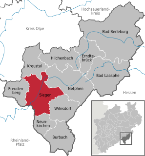
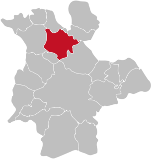
The Siegerland is a region of Germany covering the old district of Siegen and the upper part of the district of Altenkirchen, belonging to the Rhineland-Palatinate adjoining it to the west.
Flörsbachtal is a municipality in the Main-Kinzig district, in Hesse, Germany. It has a population close to 2,400. Flösbachtal contains both the oldest parish and the youngest settlement established in the Spessart hills. Located within the municipal territory is the Hermannskoppe, the highest elevation in the Hessian part of the Spessart and the Wiesbüttmoor, a rare hanging bog.
The University of Siegen is a public research university located in Siegen, North Rhine-Westphalia and is part of the Deutsche Forschungsgemeinschaft, a society of Germany's leading research universities. The University was founded in 1972. 18,618 students were enrolled at the university as of the year 2017.
Saxon Switzerland-East Ore Mountains is a district (Kreis) in the Free State of Saxony, Germany. It is named after the mountain ranges Saxon Switzerland and Erzgebirge.

Germany is a country in west-central Europe, that stretches from the Alps, across the North European Plain to the North Sea and the Baltic Sea. Germany has the second largest population in Europe and is seventh largest in area. The territory of Germany covers 357,021 km2 (137,847 sq mi), consisting of 349,223 km2 (134,836 sq mi) of land and 7,798 km2 (3,011 sq mi) of waters.

The Ruhr–Sieg railway is a 106 km long double-track, electrified main line from Hagen to Siegen via Iserlohn-Letmathe, Finnentrop and Kreuztal in the German state of North Rhine-Westphalia. The line, which has many tunnels, runs primarily through the valley of the Lenne. South of Altenhundem it crosses the watershed between the Lenne and the Sieg. The line was opened between 1859 and 1861 and is one of the oldest railways in Germany.
Vorpommern-Greifswald is a district in the east of Mecklenburg-Vorpommern, Germany. It is bounded by the districts of Mecklenburgische Seenplatte and Vorpommern-Rügen, the Baltic Sea, Poland and the state of Brandenburg. The district seat is Greifswald. A lake called Berliner See is found in the district.