
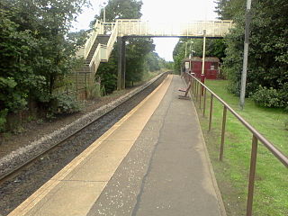
Duirinish railway station is a remote railway station on the Kyle of Lochalsh Line near the settlement of Duirinish in the Highlands, northern Scotland. The station is approximately 2 miles (3 km) inland of Scotland's west coast, near Loch Lundie. The station is 59 miles 58 chains (96.1 km) from Dingwall, between Kyle of Lochalsh and Plockton. ScotRail, who manage the station, operate all services here.

Fearn railway station is a railway station serving the village of Hill of Fearn in the Highland council area of Scotland, located around 1.3 miles (2.1 km) from the village. It is situated on the Far North Line, 40 miles 60 chains (65.6 km) form Inverness, between Tain and Invergordon, and is also the nearest station to Balintore, Hilton and Shandwick, Portmahomack and the Nigg Bay area of Easter Ross. ScotRail, who manage the station, operate all services.

Wick railway station is a railway station located in Wick, in the Highland council area in the far north of Scotland. It serves the town of Wick and other surrounding areas in the historic county of Caithness, including Staxigoe, Papigoe and Haster. The station is the terminus of the Far North Line, 161 miles 36 chains from Inverness. It is managed by ScotRail, who operate all trains serving the station.
Mosspark railway station serves the Pollok and Cardonald areas of Glasgow, Scotland. The station is on the Paisley Canal Line, 3¾ miles (6 km) west of Glasgow Central and is managed by ScotRail.
Hawkhead railway station is a railway station in the Seedhill area of Paisley, Renfrewshire, Scotland. The station is managed by ScotRail and lies on the Paisley Canal Line, 6½ miles (10 km) west of Glasgow Central.

Thornliebank railway station is a railway station in the village of Thornliebank, East Renfrewshire, Greater Glasgow, Scotland. The station is managed by ScotRail and is on the Glasgow South Western Line.
Gorbals railway station was a railway station serving the Gorbals area of Glasgow, Lanarkshire, Scotland. The station was originally part of the Glasgow, Barrhead and Kilmarnock Joint Railway.

Thrumster was a railway station located at Thrumster, Highland, Scotland between Wick and Lybster. The station building can still be seen alongside the main road in Thrumster.
Ulbster was a railway station located at Ulbster, Highland, between Wick and Lybster.
Mid Clyth was a railway station located between Wick and Lybster, Highland.
Roster Road Halt was a railway station located between Wick and Lybster in Highland, Scotland.

Occumster was a railway station located between Wick and Lybster, Highland.
Parkside Halt was a railway station located between Ulbster and Lybster, Highland.

Lybster was a railway station located on the Wick and Lybster Railway in the Highland area of Scotland. The station building now serves as the clubhouse for the Lybster golf course

Eastriggs railway station was a railway station in Dumfries and Galloway between Annan and Gretna.
Scratby Halt was a railway station on the Midland and Great Northern Joint Railway which served the Norfolk village of Scratby, England.

Balgreen Halt railway station served Balgreen in the Scottish city of Edinburgh. Services were provided by trains on the Corstorphine Branch.
The Edinburgh and Dalkeith Railway opened Portobello railway station in July 1832. It remained in use until 1846 when a replacement station was opened nearby on the NBR Main Line.

Gallowgate Central railway station was located in Glasgow, Scotland and served the Calton area of that city via the Glasgow City and District Railway. Gallowgate Central was on the Bridgeton Central branch of the modern North Clyde line, now closed.
Ballygrainey railway station was on the Belfast and County Down Railway which ran from Belfast to Donaghadee in Northern Ireland.