Dollis Brook, runs through the London Borough of Barnet in north London. It is a tributary of the River Brent, which is itself a tributary of the River Thames. The Dollis Valley Greenwalk follows almost all of Dollis Brook, apart from a short section at the beginning which passes through private land, and the London Loop follows it as far as Barnet Lane. The name Dollis is probably derived from the Middle English word 'dole', meaning the shares of land in the common field.
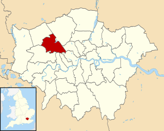
The London Borough of Barnet, located on the northern periphery of London and having much of the area within its boundaries in the Metropolitan Green Belt, has a large number of parks and open spaces. In addition there are large areas taken over by cemeteries and golf courses, and part of Hampstead Heath.
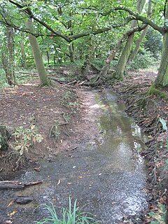
Folly Brook is a 2 1⁄4 miles (3.6 km) long brook in the London Borough of Barnet. It is a tributary of Dollis Brook, which is a tributary of the River Brent, which is a tributary of the River Thames. Folly Brook is lined for most of its length by narrow strips of woodland and scrub, with a good variety of trees and shrubs. It is one of the best streams in Barnet for small aquatic invertebrates, including several species of caddis fly and a stonefly, which are only found in unpolluted waters.
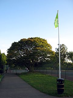
Mill Hill Park is a large public park in Mill Hill in the London Borough of Barnet. It one of Barnet's premier parks and it has been given a Green Flag Award.
Edgwarebury Park is a 22-hectare park in Edgware in the London Borough of Barnet. It was once part of the manor of Earlsbury, which was first mentioned in 1216. In the later Middle Ages it was owned by All Souls College, Oxford, and there is still evidence of the older landscape of fields and woodland. Hendon Rural District and Middlesex County Council bought the land in two parts in 1929 and 1932, and the park opened in the latter year. It is now owned and managed by Barnet Council.

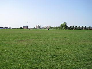
Sunny Hill Park is in Hendon, in the London Borough of Barnet, England. It is a large hilly park, 22 hectares, mainly grassed, which has extensive views to the north and the west. Together with the neighbouring Hendon Churchyard, it is a Site of Local Importance for Nature Conservation.

Moat Mount Open Space is a 110-hectare park and nature reserve in Mill Hill in the London Borough of Barnet. It is part of Moat Mount Open Space and Mote End Farm Site of Borough Importance for Nature Conservation, Grade II, which includes Barnet Gate Wood and Scratchwood Countryside Park, but is separate from Scratchwood itself, which is a neighbouring park and nature reserve. Most of the site is open to the public, but Mote End Farm and some other areas are private. Scratchwood and Moat Mount are a Local Nature Reserve.
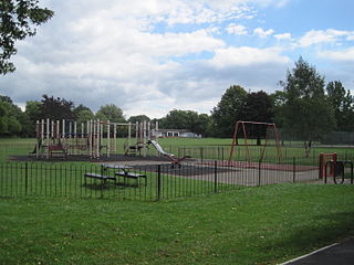
Hendon Park is a 12 hectare London suburban park situated 7 miles (11 km) north west of Charing Cross. It borders the Northern line, and Hendon Park and Northern line Railway Cutting are a Site of Local Importance for Nature Conservation.

The Dollis Valley Greenwalk is a footpath route in the London Borough of Barnet in London, England, between Moat Mount Nature Reserve in Mill Hill and Hampstead Heath. The route is designed to act as a link between the Capital Ring and the London Loop, and between the many green spaces and wildlife corridors along the way. It is approximately 10 miles (16 km) long. It mainly follows the Dollis Brook, and is one of the many parks and open spaces in Barnet.
The Coalition for a Sustainable Brent Cross Cricklewood was formed following the submission in March 2008 of a planning application to the London Borough of Barnet by developers of the Brent Cross Cricklewood scheme in the Brent Cross area of north London.

Barnet Gate Wood is a public open space in Barnet Gate, Barnet, London. It is owned and managed by the London Borough of Barnet, and is part of the Watling Chase Community Forest.

Arrandene Open Space and Featherstone Hill is a 25 hectare Site of Metropolitan Importance for Nature Conservation in Mill Hill in the London Borough of Barnet.
Brent Cross Cricklewood is a planned new town centre development in Hendon and Cricklewood, London, United Kingdom. The development is planned to cost around £4.5 billion to construct and will include 7,500 homes, 4,000,000 sq ft (370,000 m2) of offices, four parks, transport improvements and a 592,000 sq ft (55,000 m2) extension of Brent Cross Shopping Centre. The developers of the scheme are Hammerson and Standard Life.

Mutton Brook is a stream which runs between East Finchley and Hendon in the London Borough of Barnet. It is a tributary of the River Brent, which is itself a tributary of the River Thames.
Clitterhouse Recreation Ground or Clitterhouse Playing Fields is a park and Site of Local Importance for Nature Conservation in Brent Cross in the London Borough of Barnet. It is a large area of mown grass with a children's playground, bordered by thick hedges. Clitterhouse Stream, a tributary of the River Brent, runs along its eastern border.
Childs Hill Park is a public park in Childs Hill in the London Borough of Barnet. Together with the neighbouring Basing Hill Park, it is one of Barnet's 'Premier Parks'.

Basing Hill Park is a small public park in Childs Hill in the London Borough of Barnet. Together with the neighbouring Childs Hill Park it is one of Barnet's 'Premier Parks'. It is mainly grassed with scattered trees, a multipurpose tennis court/football pitch, basketball court and a children's playground.

Lyttelton Playing Fields is a 9 hectare public park in Hampstead Garden Suburb in the London Borough of Barnet. It is one of Barnet's 'Premier Parks'.

Victoria Recreation Ground is a public park in New Barnet in the London Borough of Barnet. It is one of Barnet's 'Premier Parks'.

Brent Park is a small public park of 2.24 hectares in Hendon in the London Borough of Barnet. It is part of the 'Lower Dollis Brook' Site of Borough Importance for Nature Conservation, Grade II.