West Virginia Route 46 is an east–west state highway split into two segments in Mineral County, West Virginia, United States. The western terminus of the western segment is at West Virginia Route 42 in Elk Garden. The eastern terminus is at the Maryland state line north of Beryl, where WV 46 crosses the Potomac River and intersects Maryland Route 135 on the north bank.
West Virginia Route 93 is an east–west state highway located in the Eastern Panhandle of West Virginia. WV 93 runs from U.S. Route 48 and West Virginia Route 32 in Davis in Tucker County to U.S. Route 220 near Keyser in Mineral County.
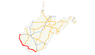
West Virginia Route 45 is a state highway in the U.S. state of West Virginia. The state highway runs 25.8 miles (41.5 km) from the Virginia state line near Glengary east to WV 230 and WV 480 in Shepherdstown. WV 45 connects the communities of Glengary and Arden in southwestern Berkeley County with the county seat of Martinsburg. The state highway also connects Shepherdstown in northern Jefferson County with Martinsburg, where the highway meets Interstate 81 (I-81), U.S. Route 11, and WV 9.
West Virginia Route 51 is a state highway that runs west to east from Berkeley County to Jefferson County in West Virginia's Eastern Panhandle. The western terminus is at West Virginia Route 45 northwest of Gerrardstown. The eastern terminus is at an interchange with U.S. Route 340 and West Virginia Route 9 east of downtown Charles Town. US 340 continues to the east on the same roadway as WV 51.
West Virginia Route 12 is a north–south route located in the southern portion of the U.S. state of West Virginia. The southern terminus of the route is at U.S. Route 219 in Peterstown, Monroe County, less than 300 yards (270 m) from the Virginia state line. It compromises a portion of the Farm Heritage Road byway between Peterstown and West Virginia Route 122. The northern terminus of the route is at U.S. Route 60 in Alta, Greenbrier County, near Interstate 64 exit 161.

West Virginia Route 16 is a north–south route located in the U.S. State of West Virginia. The southern terminus of the route is at the Virginia state line in Bishop, McDowell County, where the route continues south as Virginia State Route 16. The northern terminus is at West Virginia Route 2 in St. Marys, Pleasants County, on the south bank of the Ohio River. WV 16 continues into Virginia and North Carolina, ultimately ending in Waxhaw, south of Charlotte and just north of the South Carolina border. The total length of highway is just under 475 miles long.

West Virginia Route 17 is a north-south state highway located in the southern portion of the U.S. state of West Virginia. The southern terminus of the route is at West Virginia Route 10 in Stollings a short distance east of Logan. The northern terminus is at West Virginia Route 85 in Madison.
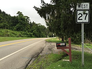
West Virginia Route 27 is an east–west state highway located within the Northern Panhandle county of Brooke in West Virginia. The western terminus of the route is at West Virginia Route 2 in Wellsburg. The eastern terminus is at the Pennsylvania state line five miles (8 km) east of Wellsburg, where WV 27 continues east into the border town of Independence as Pennsylvania Route 844.

West Virginia Route 62 is a north–south state highway in western West Virginia. The southern terminus of the route is at West Virginia Route 25 in Dunbar. The northern terminus is at Interstate 77 and U.S. Route 33 in Ripley.

West Virginia Route 83 is an east–west state highway located within McDowell County, West Virginia. The western terminus is at the Virginia state line six miles west of Jolo, where WV 83 continues west as Virginia State Route 83. The eastern terminus is at West Virginia Route 16 in War.
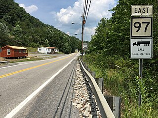
West Virginia Route 97 is an east–west state highway in the U.S. state of West Virginia. The western terminus of the route is at U.S. Route 52 and West Virginia Route 80 in Hanover. The eastern terminus is at exit 42 of the West Virginia Turnpike in Mabscott. West Virginia Route 16, which runs concurrent with WV 97 between Sophia and Mabscott, continues north into Beckley on Robert C. Byrd Drive, the right-of-way of both WV 16 and WV 97.

West Virginia Route 891 is a 2-mile (3.2 km) long east–west state highway located in Marshall County, West Virginia. The western terminus of the route is at U.S. Route 250 roughly three miles north of Cameron. The eastern terminus is at the Pennsylvania state line, where WV 891 continues east as Pennsylvania Route 21.
West Virginia Route 480 is a 5.64-mile-long (9.08 km) state highway in the U.S. state of West Virginia. Known for most of its length as Kearneysville Pike, the highway extends from WV 115 in Kearneysville north to the Maryland state line at the Potomac River in Shepherdstown, from where the highway continues as Maryland Route 34. The route is one of the main north–south highways of northern Jefferson County and passes through the campus of Shepherd University. WV 480 was originally established in the early 1920s as West Virginia Route 48. The highway was paved in the mid-1920s, which included a different routing through Shepherdstown. WV 48's present routing through the town was established in the late 1930s when the first James Rumsey Bridge was completed; that bridge was replaced with the current bridge in the mid-2000s. WV 48 was renumbered to WV 480 in the mid-1970s after U.S. Route 48 was established in West Virginia and Maryland.

West Virginia Route 331 is an east–west state highway located entirely in Jackson County, West Virginia. The western terminus of the route is at West Virginia Route 2 and West Virginia Route 62 in Mount Alto. The eastern terminus is at WV 62 near Cottageville.

West Virginia Route 161 is a north–south state highway located entirely within McDowell County, West Virginia. The southern terminus of the route is at West Virginia Route 16 in Bishop less than 900 feet (270 m) from the Virginia state line. The northern terminus is at U.S. Route 52 in Elkhorn.

West Virginia Route 105 is an east–west state highway located within Weirton, West Virginia, United States. The western terminus of the route is at West Virginia Route 2 north of downtown Weirton. The eastern terminus is at U.S. Route 22 in Weirton Heights, just 1/2 mile west of the Pennsylvania state line.
U.S. Route 52 (US 52) skirts the western fringes of the U.S. state of West Virginia. It runs from the Virginia state line near Bluefield, where it is concurrent with Interstate 77 (I-77), in a general northwest and north direction to I-64 at Kenova. There it turns east, overlapping I-64 for five miles (8.0 km) before splitting off onto the West Huntington Expressway into Ohio via the West Huntington Bridge. Despite having an even number, US 52 is signed north–south in West Virginia. In some other states along its route, it is signed east-west. The West Virginia segment is signed such that US 52 north corresponds to the general westward direction of the highway, and vice versa. For a while, US 52 parallels US 23, which is on the other side of the Big Sandy River in Kentucky. This continues into Ohio, where US 52 travels on the Ohio side of the Ohio River while US 23 travels on the Kentucky side.

Anawalt Lake Wildlife Management Area is a 1,792-acre (725 ha) protected area located in McDowell County, West Virginia.The terrain at Anawalt lake is steep, and covered with a second-growth hardwood forest. A mixed oak-hickory forest habitat dominates the drier slopes, with yellow poplar and black cherry in the moister coves.

Virginia State Route 102 and West Virginia Route 102 are adjoining state highways in the U.S. states of Virginia and West Virginia. The two state highways together run 11.4 miles (18.3 km) from Center Street in Pocahontas, Virginia east to the Virginia – West Virginia state line between the twin cities of Bluefield, Virginia and Bluefield, West Virginia. Most of Route 102 consists of three sections in Virginia maintained by the Virginia Department of Transportation (VDOT); the two intervening sections in West Virginia are maintained by the West Virginia Division of Highways. In addition to connecting Pocahontas with the two Bluefields, the state highway passes through Nemours, West Virginia and Falls Mills, Virginia and provides access to Bluefield College.