
Kentucky, officially the Commonwealth of Kentucky, is a state in the Southeastern region of the United States and one of the states of the Upper South. Kentucky borders Illinois, Indiana, and Ohio to the north, West Virginia to the northeast, Virginia to the east, Tennessee to the south, and Missouri to the west. Its northern border is defined by the Ohio River. Its capital is Frankfort and its largest city is Louisville. Its population was approximately 4.5 million in 2020.

Muhlenberg County is a county in the U.S. Commonwealth of Kentucky. As of the 2020 census, the population was 30,928. Its county seat is Greenville and its largest city is Central City.

Hopkins County is a county located in the western part of the U.S. state of Kentucky. As of the 2020 census, the population was 45,423. Its county seat is Madisonville. Hopkins County was created December 9, 1806 from Henderson County. It was named for General Samuel Hopkins, an officer in both the American Revolutionary War and War of 1812, and later a Kentucky legislator and U.S. Congressman.

Henderson County is a county in the U.S. state of Kentucky. The county is located in western Kentucky on the Ohio River across from Evansville, Indiana. As of the 2020 census, the population was 44,793. Its county seat is Henderson.

Butler County is a county located in the US state of Kentucky. As of the 2020 Census, the population was 12,371. Its county seat is Morgantown. The county was formed in 1810, becoming Kentucky's 53rd county. Butler County is included in the Bowling Green, Kentucky, Metropolitan Statistical Area.
Hopkinsville is a home rule-class city in and the county seat of Christian County, Kentucky, United States. The population at the 2020 census was 31,180.

Nortonville is a home rule-class city in Hopkins County, Kentucky, in the United States. The population was 1,204 as of the 2010 census.

Dawson Springs is a home rule-class city in Hopkins and Caldwell counties in the U.S. state of Kentucky. As of the 2020 census, the population of the city was 2,452.

The Pennyroyal Plateau or Pennyroyal Region, often spelled Pennyrile, is a large physiographic region of Kentucky that features rolling hills, caves, and karst topography in general. It is named for Hedeoma pulegioides, a wild mint that grows in the area. It is also called the "Mississippian Plateau," for the Mississippian geologic age in which it was formed.
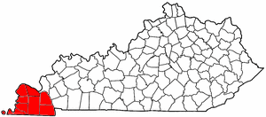
The Jackson Purchase, also known as the Purchase Region or simply the Purchase, is a region in the U.S. state of Kentucky bounded by the Mississippi River to the west, the Ohio River to the north, and the Tennessee River to the east.

Southern Illinois, also known as Little Egypt, is the southern third of Illinois, principally along and south of Interstate 64. Although part of a Midwestern state, this region is aligned in culture more with that of the Upland South rather than the Midwest. Part of downstate Illinois, it is bordered by the two most voluminous rivers in the United States: the Mississippi below its connecting Missouri River to the west and the Ohio River to the east and south with the Wabash as tributary.

The Cumberland Plateau is the southern part of the Appalachian Plateau in the Appalachian Mountains of the United States. It includes much of eastern Kentucky and Tennessee, and portions of northern Alabama and northwest Georgia. The terms "Allegheny Plateau" and the "Cumberland Plateau" both refer to the dissected plateau lands lying west of the main Appalachian Mountains. The terms stem from historical usage rather than geological difference, so there is no strict dividing line between the two. Two major rivers share the names of the plateaus, with the Allegheny River rising in the Allegheny Plateau and the Cumberland River rising in the Cumberland Plateau in Harlan County, Kentucky.
The West Kentucky Coal Field comprises an area in the west-central and northwestern part of the state, bounded by the Dripping Springs Escarpment and the Pennyroyal Plateau and the Ohio River, but is part of the Illinois Basin that extends into Indiana and Illinois. It is characterized by Pennsylvanian age sandstones, shales and coal. Nearly all of the counties in the area are part of the television market known as the Kentucky–Illinois–Indiana tri-state area.

The Tradewater River is a tributary of the Ohio River, approximately 136 miles (219 km) long, in western Kentucky in the United States. It drains an area of 932 square miles (2,410 km2) in the limestone hills south of Evansville, Indiana, between the basins of the Cumberland River on the west and the Green River on the east.

The Upland South and Upper South are two overlapping cultural and geographic subregions in the inland part of the Southern United States. They differ from the Deep South and Atlantic coastal plain by terrain, history, economics, demographics, and settlement patterns.

WKDZ-FM is a radio station licensed in Cadiz, Kentucky. WKDZ-FM is owned by Ham Broadcasting. Beth Mann serves as Ham Broadcasting owner/president.

Interstate 69 (I-69) in the US state of Kentucky is a 148.1-mile-long (238.3 km) freeway running from Fulton to Henderson. The route makes use of the entirety of the former Purchase Parkway and existing portions of I-24, the Western Kentucky Parkway, and the Pennyrile Parkway. Eventually, I-69 will leave the former Pennyrile Parkway just south of the Audubon Parkway interchange or remain on its current alignment and travel through Henderson on U.S. Route 41 (US 41) north into Indiana. The proposed route for the remainder of I-69 in Kentucky travels about 10 miles (16 km) to utilize an as-of-yet-unbuilt bridge into Indiana.

Kentucky is situated in the Upland South. A significant portion of eastern Kentucky is part of Appalachia.
The geology of Kentucky formed beginning more than one billion years ago, in the Proterozoic eon of the Precambrian. The oldest igneous and metamorphic crystalline basement rock is part of the Grenville Province, a small continent that collided with the early North American continent. The beginning of the Paleozoic is poorly attested and the oldest rocks in Kentucky, outcropping at the surface, are from the Ordovician. Throughout the Paleozoic, shallow seas covered the area, depositing marine sedimentary rocks such as limestone, dolomite and shale, as well as large numbers of fossils. By the Mississippian and the Pennsylvanian, massive coal swamps formed and generated the two large coal fields and the oil and gas which have played an important role in the state's economy. With interludes of terrestrial conditions, shallow marine conditions persisted throughout the Mesozoic and well into the Cenozoic. Unlike neighboring states, Kentucky was not significantly impacted by the Pleistocene glaciations. The state has extensive natural resources, including coal, oil and gas, sand, clay, fluorspar, limestone, dolomite and gravel. Kentucky is unique as the first state to be fully geologically mapped.