Wheeling, Mississippi

Last updated
Wheeling, Mississippi
Ghost town
USA Mississippi location map.svg
Red pog.svg
Wheeling
Usa edcp location map.svg
Red pog.svg
Wheeling
Coordinates: 34°08′27″N88°22′44″W / 34.14083°N 88.37889°W / 34.14083; -88.37889 Coordinates: 34°08′27″N88°22′44″W / 34.14083°N 88.37889°W / 34.14083; -88.37889
Country United States
State Mississippi
County Itawamba
Elevation 246 ft (75 m)
Time zone Central (CST) (UTC-6)
  Summer (DST) CDT (UTC-5)
GNIS feature ID 706280 [1]

Wheeling is a ghost town located in Itawamba County, Mississippi.

Ghost town City depopulated of inhabitants and that stays practically intact

A ghost town is an abandoned village, town, or city, usually one that contains substantial visible remains. A town often becomes a ghost town because the economic activity that supported it has failed, or due to natural or human-caused disasters such as floods, prolonged droughts, government actions, uncontrolled lawlessness, war, pollution, or nuclear disasters. The term can sometimes refer to cities, towns, and neighbourhoods that are still populated, but significantly less so than in past years; for example, those affected by high levels of unemployment and dereliction.

Itawamba County, Mississippi County in the United States

Itawamba County is a county located in the U.S. state of Mississippi. As of the 2010 census, the population was 23,401. Its county seat is Fulton. The county is part of the Tupelo, MS Micropolitan Statistical Area.

Established in the early 19th century following the sale of the Chickasaw lands, Wheeling was a port on the Tombigbee River, located "a few miles below" the village of Van Buren. Wheeling had a hotel and merchants, though "its life was very short", and Van Buren absorbed its businesses. [2]

Chickasaw indigenous people of Southeastern Woodlands of the US

The Chickasaw are an indigenous people of the Southeastern Woodlands. Their traditional territory was in the Southeastern United States of Mississippi, Alabama and Tennessee. They are of the Muskogean language family and are federally recognized as the Chickasaw Nation.

Tombigbee River river in the United States of America

The Tombigbee River is a tributary of the Mobile River, approximately 200 mi (325 km) long, in the U.S. states of Mississippi and Alabama. Together with the Alabama, it merges to form the short Mobile River before the latter empties into Mobile Bay on the Gulf of Mexico. The Tombigbee watershed encompasses much of the rural coastal plain of western Alabama and northeastern Mississippi, flowing generally southward. The river provides one of the principal routes of commercial navigation in the southern United States, as it is navigable along much of its length through locks and connected in its upper reaches to the Tennessee River via the Tennessee-Tombigbee Waterway.

Van Buren, Mississippi Ghost town in Mississippi, United States

Van Buren is a ghost town located in Itawamba County, Mississippi.

The former settlement is today covered by forest, located on the east bank of the Tennessee–Tombigbee Waterway.

Tennessee–Tombigbee Waterway

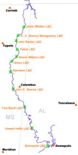
The Tennessee–Tombigbee Waterway is a 234-mile (377 km) man-made waterway that extends from the Tennessee River to the junction of the Black Warrior-Tombigbee River system near Demopolis, Alabama, United States. The Tennessee–Tombigbee Waterway links commercial navigation from the nation's midsection to the Gulf of Mexico. The major features of the waterway are ten locks and dams, a 175-foot-deep (53 m) cut between the Tombigbee River watershed and the Tennessee River watershed, and 234 miles (377 km) of navigation channels. The ten locks are 9 by 110 by 600 feet, the same dimension as the locks on the Mississippi above Lock and Dam 26 at Alton, Illinois. Under construction for twelve years by the U.S. Army Corps of Engineers, the Tennessee–Tombigbee Waterway was completed in December 1984 at a total cost of nearly $2 billion.

Related Research Articles

Tishomingo County, Mississippi County in the United States

Tishomingo County is a county located in the northeast corner of the U.S. state of Mississippi. As of the 2010 census, the population was 19,593. Its county seat is Iuka.

Van Buren County, Michigan County in the United States

Van Buren County is a county located in the U.S. state of Michigan. As of the 2010 census, the population was 76,258. The county seat is Paw Paw. The county was founded in 1829 and organized in 1837.

Van Buren, Arkansas City in Arkansas, United States

Van Buren is the second largest city in the Fort Smith, Arkansas-Oklahoma Metropolitan Statistical Area and the county seat of Crawford County, Arkansas, United States. The city is located directly northeast of Fort Smith at the Interstate 40 - Interstate 540 junction. The city was incorporated in 1845 and as of the 2010 census had a population of 22,791, ranking it as the state's 22nd largest city, behind Searcy.

Cotton Gin Port, Mississippi human settlement in Mississippi, United States of America

Cotton Gin Port is a ghost town in Monroe County, Mississippi, United States.

The Gaines Trace was a road in the Mississippi Territory. It was constructed in 1811 and 1812 from the Tennessee River to Cotton Gin Port on the upper Tombigbee River and on to Fort Stoddert on the lower Tombigbee. The portion from the Tennessee River to Cotton Gin Port was surveyed in 1807 and 1808 by Edmund P. Gaines, the road's namesake.

East Fork Tombigbee River was a historical name of a tributary stream of the Tombigbee River in northeast Mississippi. Its confluence with Town Creek in Monroe County was the historical beginning of the Tombigbee. Today, however, what was once known as the east fork is now designated as the Tombigbee.

Hamilton, Mississippi Unincorporated community and census-designated place in Mississippi, United States

Hamilton is an unincorporated community and census-designated place in Monroe County, Mississippi.

Tombigbee National Forest

Tombigbee National Forest is a U.S. National Forest in eastern and northeastern Mississippi. It is named for the nearby Tombigbee River. It is divided geographically into two non-contiguous sections. The larger southern section, about 60% of the total acreage, is located north of Louisville, in parts of Winston, Choctaw, and Oktibbeha counties in eastern Mississippi. The smaller northern section, about 40% of the total acreage, is located northeast of Houston, in parts of Chickasaw and Pontotoc counties in northeastern Mississippi. As a whole the forest lies, in descending order of land area, in Winston, Chickasaw, Choctaw, Pontotoc, and Oktibbeha counties. The forest has a total area of 67,005 acres. Headquarters of forest administration is in Jackson, as are those for all six National Forests in Mississippi, but local ranger district offices are located in Ackerman. The forest contains the Owl Creek Mounds, which include five platform mounds built between 1100 and 1200 CE.

Tombigbee State Park

Tombigbee State Park is a public recreation area located off Mississippi Highway 6 approximately 5 miles (8.0 km) east of Tupelo, Mississippi. The state park surrounds 90-acre (36 ha) Lake Lee and is named for the nearby Tombigbee River.

Plymouth, Mississippi

Plymouth was an early settlement in Mississippi in present-day Lowndes County. Plymouth was located at 33°31′23″N88°30′06″W on the west bank of the Tombigbee River. It was formed around 1819, nucleating at the fortified house of John Pitchlynn, the U.S. interpreter for the Choctaw Agency for communications with the Choctaw Nation. The low-lying landing site of the village was prone to repeated flooding. While both Plymouth and its sister town of Columbus across the river had high bluffs, Plymouth's landing site did not have easy access to the bluff heights. By the 1840s, the village site was abandoned, with most of the residents moving across the river.

Van Buren County Courthouse (Iowa) courthouse in Iowa

The Van Buren County Courthouse located in Keosauqua, Iowa, United States, was built in 1843. It was listed on the National Register of Historic Places in 1977 as a part of the County Courthouses in Iowa Thematic Resource. It is the only building the county has used as its courthouse, and it is the oldest courthouse in Iowa. In 1845 the courthouse served as the location for a trial resulting in the first death penalty in Iowa history.

Tombigbee District

The Tombigbee District, also known as the Tombigbee settlements, was one of two areas, the other being the Natchez District, that were the first in what was West Florida to be colonized by British subjects from the Thirteen Colonies and elsewhere. This later became the Mississippi Territory as part of the United States. The district was also the first area to be opened to white settlement in what would become the state of Alabama, outside of the French colonial outpost of Mobile on the Gulf Coast. The Tombigbee and Natchez districts were the only areas populated by whites in the Mississippi Territory when it was formed by the United States in 1798.

Holcut, Mississippi human settlement in Mississippi, United States of America

Holcut was a small town located in Tishomingo County, Mississippi, United States. In 1976, the U.S. Army Corps of Engineers bought out and demolished the town because it lay in the path of the Divide Cut, a 29-mile (47 km) canal section of the Tennessee–Tombigbee Waterway, which was constructed between 1972 and 1984.

Bigbee Valley, Mississippi Unincorporated community in Mississippi, United States

Bigbee Valley is an unincorporated community in Noxubee County, Mississippi, United States. Variant names are "Bigbeevale", "Nances Mill", and "Whitehall".

Moores Bluff, Mississippi Ghost town in Mississippi, United States

Moores Bluff is a ghost town in Lowndes County, Mississippi, United States.

Nashville, Mississippi Ghost town in Mississippi, United States

Nashville is a ghost town in Lowndes County, Mississippi, United States.

References