The Broads is a network of mostly navigable rivers and lakes in the English counties of Norfolk and Suffolk. Although the terms "Norfolk Broads" and "Suffolk Broads" are correctly used to identify specific areas within the two counties respectively, the whole area is frequently referred to as the Norfolk Broads.

Wroxham is a village and civil parish in the English county of Norfolk. The civil parish of Wroxham has an area of 6.21 square kilometres, and in 2001, had a population of 1,532 in 666 households. A reduced population of 1,502 in 653 households was noted in the 2011 Census. The village is situated within the Norfolk Broads on the south side of a loop in the middle reaches of the River Bure. It lies in an elevated position above the Bure, between Belaugh Broad to the west, and Wroxham Broad to the east and south east. Wroxham is some eight miles north-east of Norwich, to which it is linked by the A1151 road. The village and broad lie in an area of fairly intensive agriculture, with areas of wet woodland adjoining the broad and river. For the purposes of local government, the parish falls within the district of Broadland although the river, broad and their immediate environs fall within the executive area of the Broads Authority. On the northern side of the Bure is the village of Hoveton, often confused with Wroxham.

Horning is an ancient village and parish in the English county of Norfolk. It covers an area of 11 km2 and had a population of approximately 1,100 in the 2021 census. Horning parish lies on the northern bank of the River Bure south of the River Thurne and is located in The Broads National Park. For the purposes of local government, it falls within the district of North Norfolk, although areas alongside the rivers and broads fall into the executive area of the Broads Authority.

Barton Broad is a large lake that forms part of the River Ant which gives its name to a 164-hectare (410-acre) nature reserve north-east of Norwich in Norfolk. The reserve is owned and managed by the Norfolk Wildlife Trust. It is part of the Ant Broads and Marshes Site of Special Scientific Interest and National Nature Reserve, and part of it is in the Ant Marshes Nature Conservation Review site, Grade I. It is part of the Broadland Ramsar site and Special Protection Area, and The Broads Special Area of Conservation.

Wroxham Broad is an area of open water alongside the River Bure near the village of Wroxham in Norfolk, England within The Broads National Park. The Norfolk Broads were formed by the flooding of ancient peat workings. Wroxham Broad has an area of 34.4 hectares and a mean depth of 1.3 metres. It lies to the west of the Bure, with two navigable openings between river and broad. The village and broad lie in an area of fairly intensive agriculture, with areas of wet woodland adjoining the broad and river.

The River Bure is a river in the county of Norfolk, England, most of it in the Broads. The Bure rises near Melton Constable, 11 miles (18 km) upstream of Aylsham, which was the original head of navigation. Nowadays, the head of navigation is 10 miles (16 km) downstream at Coltishall Bridge. After Aylsham Lock and Burgh Bridge, the Bure passes through Buxton Lammas, Coltishall, Belaugh, Wroxham, Horning, past St. Benet's Abbey, through Oby, Acle, Stokesby, along the northern border of the Halvergate Marshes, through Runham and Great Yarmouth where it meets Breydon Water and flows into the sea at Gorleston.
The River Ant is a tributary river of the River Bure in the county of Norfolk, England. It is 27 kilometres (17 mi) long, and has an overall drop of 27 metres from source to mouth. It is said that the Ant was formerly known as the River Smalea and that this is the origin of the name of the village of Smallburgh. The modern name is a back-formation from Antingham.

The North Walsham and Dilham Canal is a waterway in the English county of Norfolk. It was authorised by Parliament in 1812, but work on the construction of a canal which ran parallel to a branch of the River Ant did not start until 1825. It included six locks, which were sized to accommodate wherries, and was officially opened in August 1826. It was 8.7 miles (14.0 km) long and ran from two bone mills at Antingham to a junction with the River Ant at Smallburgh. It carried offal for the bone mills and agricultural products, as it proved cheaper to land coal on the beach at Mundesley and cart it overland than to use the canal.

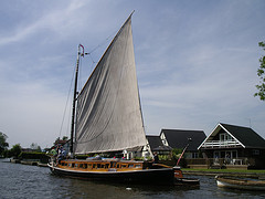
The Norfolk wherry is a type of sailing boat used on The Broads in Norfolk and Suffolk, England. Three main types were developed over its life, all featuring the distinctive gaff rig with a single, high-peaked sail and the mast stepped well forward.

Coot Club is the fifth book of Arthur Ransome's Swallows and Amazons series of children's books, published in 1934. The book sees Dick and Dorothea Callum visiting the Norfolk Broads during the Easter holidays, eager to learn to sail and thus impress the Swallows and Amazons when they return to the Lake District later that year. Along with a cast of new characters, Dick and Dorothea explore the North and South Broads and become 'able seamen'.

Albion is a Norfolk wherry. Built in 1898, she served as a trading vessel and then as a lighter, until being acquired by the Norfolk Wherry Trust for restoration and preservation in 1949. Since 1981 she has been moored at the Norfolk Wherry Trust wherry base at Womack Water near Ludham. She is listed on the register of National Historic Ships in the United Kingdom as part of the National Historic Fleet.
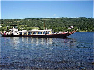
The steam yacht Gondola is a rebuilt Victorian, screw-propelled, steam-powered passenger vessel on Coniston Water, England. Originally launched in 1859, she was built for the steamer service carrying passengers from the Furness Railway and from the Coniston Railway. She was in commercial service until 1936 when she was retired, being converted to a houseboat in 1946. In 1979, by now derelict, she was given a new hull, engine, boiler and most of the superstructure. She is back in service as a passenger boat, still powered by steam and now operated by the National Trust.

The Norfolk Wherry Trust is a waterway society and UK registered charity number 1084156, based at Womack Water near Ludham in the Norfolk Broads, Norfolk, England.
The Norfolk Heritage Fleet Trust is a waterway society and charitable trust based at Hunter's Yard, Ludham on the Norfolk Broads, England, UK. The Trust maintains and hires out a fleet of wooden sailing yachts from the 1930s.

The East Anglian Waterways Association is a waterway society and an umbrella organisation in East Anglia, England, UK.

Maud, along with Albion, is one of only two surviving Norfolk trading wherries to be found on the Norfolk Broads. Maud was built in 1899, and served as a sailing wherry and later as a lighter before being sunk in the mid-1960s as protection for part of the banks of Ranworth Broad. In 1981, she was refloated and taken to Upton where she was restored over a number of years, finally returning to the water in 1999. As of 2010, Maud is active on the Norfolk Broads. She is listed on the register of National Historic Ships in the United Kingdom, as part of the National Historic Fleet.

Hathor (1905) is one of only six surviving Norfolk pleasure wherries to be found on the Norfolk Broads. Like two of the other surviving wherries, Maud and Solace, she was built by Daniel S. Hall of Reedham. Hathor has been listed on the register of National Historic Ships in the United Kingdom since 1996 and is part of the National Historic Fleet.

RNLB Alfred Corry is a Norfolk and Suffolk-class, non-self-righting, sailing and rowing lifeboat which served in the town of Southwold in the county of Suffolk. The boat was funded and crewed by the Royal National Lifeboat Institution (RNLI). She is kept on display in a museum in Southwold.

Britannia (BN72) is the last working Class One East Coast Smack. She was built in King's Lynn in 1914 and launched in 1915, and is currently (2021) undergoing restoration in Devon, and due to be relaunched in 2022. She measures 16.82 metres (55.2 ft) long with a beam of 4.05 metres (13.3 ft).