Whitrope is a densely forested, but sparsely populated area, high in the Southern Upland hills in the south central Scottish Borders in the former county of Roxburghshire. Situated some 12 miles south from Hawick on the B6399 road, the Scottish watershed passes through the area; Whitrope Burn draining south towards Newcastleton and Flosh Burn draining north towards Hawick.
The main features are the large forests managed by the Forestry Commission, and artefacts of Railway heritage. The Waverley Railway line passed over the whitrope summit in the Whitrope Tunnel at an elevation of 1,006 feet or 307 metres. The Rail Heritage Centre is slightly south-west of this and is the headquarters of the Waverley Route Heritage Association. A length of track has been re-installed and there is a collection of rail rolling stock at the Whitrope Siding station.
A network of Heritage Trails has been established, including the Ritson Trail, named after William Ritson, a contractor from the Victorian era, and responsible for the Shankend Viaduct, Riccarton Junction, and Whitrope Tunnel and summit.
Hawick is a town in the Scottish Borders council area and historic county of Roxburghshire in the east Southern Uplands of Scotland. It is 10 miles (16.1 km) south-west of Jedburgh and 8.9 miles (14.3 km) south-southeast of Selkirk. It is one of the farthest towns from the sea in Scotland, in the heart of Teviotdale, and the biggest town in the former county of Roxburghshire. The town is at the confluence of the Slitrig Water with the River Teviot.
The Scottish Borders is one of 32 council areas of Scotland. It borders the City of Edinburgh, Dumfries and Galloway, East Lothian, Midlothian, South Lanarkshire, West Lothian and, to the south-west, south and east, the English counties of Cumbria and Northumberland. The administrative centre of the area is Newtown St Boswells.
The Rimutaka Incline was a 3-mile-long (4.8 km), 3 ft 6 in gauge railway line on an average grade of 1-in-15 using the Fell system between Summit and Cross Creek stations on the Wairarapa side of the original Wairarapa Line in the Wairarapa district of New Zealand. The term "Rimutaka Incline" is sometimes used incorrectly to refer to other parts or all of the closed and deviated section of the Wairarapa Line between Upper Hutt and Speedy's Crossing, near Featherston. The incline formation is now part of the Remutaka Rail Trail.
The Waverley Route was a railway line that ran south from Edinburgh, through Midlothian and the Scottish Borders, to Carlisle. The line was built by the North British Railway; the stretch from Edinburgh to Hawick opened in 1849 and the remainder to Carlisle opened in 1862. The line was nicknamed after the immensely popular Waverley Novels, written by Sir Walter Scott.
The Southern Uplands are the southernmost and least populous of mainland Scotland's three major geographic areas. The term is used both to describe the geographical region and to collectively denote the various ranges of hills and mountains within this region. An overwhelmingly rural and agricultural region, the Southern Uplands are partly forested and contain many areas of open moorland - the hill names in the area are congruent with these characteristics.
A bank engine, banking engine, helper engine or pusher engine is a railway locomotive that temporarily assists a train that requires additional power or traction to climb a gradient. Helpers/bankers are most commonly found in mountain divisions, where the ruling grade may demand the use of substantially greater motive power than that required for other grades within the division.
The Whitrope Tunnel is a disused railway tunnel in the Scottish Borders, situated 12 miles (19 km) south of Hawick on the Waverley Route, close to Whitrope. It has a length of 1,208 yards (1,105 m).
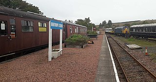
Whitrope Siding was a trailing short siding or spur off the "up" (southbound) line, an associated trailing cross-over between up and down lines, a pair of railway cottages and a signal box on the Waverley Line or Waverley Route. It was used as a goods loading bay. The site is now the home of the Whitrope Heritage Centre, as well as the current terminus of the heritage Border Union Railway.
Waverley Route Heritage Association is a heritage railway group involved with the history, heritage and preservation of the Waverley Route, based/centred on Whitrope, south of Hawick, Scotland.
Shankend Manor was a sixteenth-century mansion located some six miles south of Hawick, close to Whitrope Siding in Scotland. It was constructed to manage the surrounding countryside and now overlooks the Edinburgh Waverley line. The manor fell into disuse during the 1930s and by the 1970s had been removed from local road maps. The Maiden Paps are located close to Shankend.
Belses is a village on the Ale Water, in the Scottish Borders area of Scotland the former Selkirkshire. It is situated close to Old Belses, and lies south of St Boswells, west of Jedburgh, north of Hawick, and east of Selkirk.
Gorebridge is a railway station on the Borders Railway, which runs between Edinburgh Waverley and Tweedbank. The station, situated 11 miles 77 chains (19 km) south-east of Edinburgh Waverley, serves the town of Gorebridge in Midlothian, Scotland. It is owned by Network Rail and managed by ScotRail.
Galashiels is a railway station on the Borders Railway, which runs between Edinburgh Waverley and Tweedbank. The station, situated 33 miles 22 chains (54 km) south-east of Edinburgh Waverley, serves the town of Galashiels in Scottish Borders, Scotland. It is owned by Network Rail and managed by ScotRail.
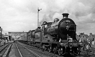
Riccarton Junction, in the county of Roxburghshire in the Scottish Borders, was a railway village and station. In its heyday it had 118 residents and its own school, post office and grocery store. The station was an interchange between the Border Counties Railway branch to Hexham and the North British Railway's (NBR's) Border Union Railway.
The Border Union Railway was a railway line which connected places in the south of Scotland and Cumberland in England. It was authorised on 21 July 1859 and advertised as the Waverley Route by the promoters - the North British Railway. It connected the Edinburgh and Hawick Railway at Hawick with Carlisle.
The Borders Abbeys Way is a long-distance footpath in the Scottish Borders area of Scotland. It is a circular walkway and is 109 kilometres (68 mi) in length. The theme of the footpath is the ruined Borders abbeys along its way: Kelso Abbey, Jedburgh Abbey, Melrose Abbey and Dryburgh Abbey. These abbeys were homes to monks, who lived there between the 12th and 16th centuries. The route also passes through the towns of Hawick and Selkirk, and close to Abbotsford House, the home of Sir Walter Scott. Along the Borders Abbeys Way there are several rivers: Jed Water, River Teviot, River Tweed, Ale Water, and Rule Water.
Hawick railway station served the town of Hawick, Scottish Borders, Scotland from 1849 to 1969 on the Waverley Route.
The Borders Railway connects the city of Edinburgh with Galashiels and Tweedbank in the Scottish Borders. The railway follows most of the alignment of the northern part of the Waverley Route, a former double-track line in southern Scotland and northern England that ran between Edinburgh and Carlisle. That line was controversially closed in 1969, as part of the Beeching cuts, leaving the Borders region without any access to the National Rail network. Following the closure, a campaign to revive the Waverley Route emerged. Discussion on reopening the northern part of the line came to a head during the early 2000s. Following deliberations in the Scottish Parliament, the Waverley Railway (Scotland) Act 2006 received Royal Assent in June 2006. The project was renamed the "Borders Railway" in August 2008, and building works began in November 2012. Passenger service on the line began on 6 September 2015, whilst an official opening by Queen Elizabeth II took place on 9 September.
Shankend Viaduct is a former railway viaduct in the Scottish Borders just over six miles south of the town of Hawick. It is a category B listed building.
This page is based on this Wikipedia article Text is available under the CC BY-SA 4.0 license; additional terms may apply. Images, videos and audio are available under their respective licenses.