
Perthshire, officially the County of Perth, is a historic county and registration county in central Scotland. Geographically it extends from Strathmore in the east, to the Pass of Drumochter in the north, Rannoch Moor and Ben Lui in the west, and Aberfoyle in the south; it borders the counties of Inverness-shire and Aberdeenshire to the north, Angus to the east, Fife, Kinross-shire, Clackmannanshire, Stirlingshire and Dunbartonshire to the south and Argyllshire to the west. It was a local government county from 1890 to 1930.

Thurso is a town and former burgh on the north coast of the Highland council area of Scotland. Situated in the historical area of Caithness, it is the northernmost town on the British mainland.

Ross and Cromarty, sometimes referred to as Ross-shire and Cromartyshire, is a variously defined area in the Highlands and Islands of Scotland. There is a registration county and a lieutenancy area in current use, the latter of which is 8,019 square kilometres in extent. Historically there has also been a constituency of the Parliament of the United Kingdom, a local government county, a district of the Highland local government region and a management area of the Highland Council. The local government county is now divided between two local government areas: the Highland area and Na h-Eileanan Siar. Ross and Cromarty border Sutherland to the north and Inverness-shire to the south.

Caithness is a historic county, registration county and lieutenancy area of Scotland.

Helmsdale is a village on the east coast of Sutherland, in the Highland council area of Scotland. The modern village was planned in 1814 to resettle communities that had been removed from the surrounding straths as part of the Highland Clearances.
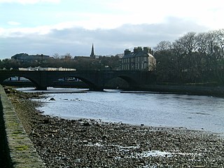
Wick is a town and royal burgh in Caithness, in the far north of Scotland. The town straddles the River Wick and extends along both sides of Wick Bay. "Wick Locality" had a population of 6,954 at the time of the 2011 census, a decrease of 3.8% from 2001.
Achairn Burn, known also as Haster Burn, is one of the major tributaries of Wick River, in Caithness, in the Highland area of Scotland. The burn's source is in headwaters flowing from the northern slope of the Hill of Toftgunn, which rises to over 170 metres, and in Camster Loch, which is at nearly 120 metres, between the Hill of Toftgunn and Ballharn Hill. The same area feeds also another major tributary of Wick River, the Camster/Rowans-Strath Burn. Achairn Burn enters Wick River at Mary Ford, about 10 kilometres to the northeast of the burn's source. Its entire course is within Caithness, as is the whole of the catchment basin of Wick River.
Scouthal Burn has its source in the Flow Country of Caithness, in the Highland area of Scotland, at a height of around 50 metres, at the confluence of the Burn of Achorole and Alt Feithe Buidhe and about three kilometres south/southwest of the village of Watten.
Strath Burn is a stream which has its source in the Flow Country of Caithness, Scotland, at a height above sea level of around 70 metres, at the confluence of Kensary Burn, and Rowens Burn, and about five kilometres south of the village of Watten.

The River Thurso has Loch Rumsdale in Caithness as its source, about 26 kilometres south and 14 kilometres west of the burgh of Thurso, Caithness, and about 2 kilometres south of the railway line linking the burghs of Thurso and Wick with Inverness. At its source and until it reaches Loch More the river is known also as Strathmore Water. Caithness is in the Highland area of Scotland.
Forss Water, known also as Forss River, has its source at the northern end of Loch Shurrey, at grid reference ND042568. About 13 kilometres north of its source the river flows into Crosskirk Bay and the Atlantic Ocean at ND029700. Crosskirk Bay is on the north coast of Great Britain and about 8 kilometres west of the burgh of Thurso, Caithness, in Highland, Scotland. The river marked the eastern extent of the Clan Mackay raid in the Sandside Chase of 1437.
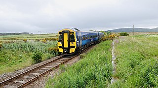
The Far North Line is a rural railway line entirely within the Highland area of Scotland, extending from Inverness to Thurso and Wick. As the name suggests, it is the northernmost railway in the United Kingdom. The line is entirely single-track, with only crossing loops at some intermediate stations allowing trains to pass each other. In common with other railway lines in the Highlands and northern Lowlands, it is not electrified and all trains are diesel-powered.

The A882 road is entirely within Caithness in the Highland area of Scotland. It has a length of about 23 kilometres (14 mi) and runs generally west/northwest from the A99 in the county town of Wick to the A9 in the Georgemas area.

Bonar Bridge is a village on the north bank of the Kyle of Sutherland to the west and the Dornoch Firth to the east in the Parish of Creich in the Highland council area of Scotland.

Watten is a small village in Caithness, in the Highland area of Scotland, on the main road (A882-A9) between the burgh of Wick and the town of Thurso, about twelve kilometres west of Wick and close to Wick River and to Loch Watten. The village is on The Far North railway line but trains stopped calling at the village in 1960. The railway station is now a private house.

Kinbrace railway station is a railway station serving the village of Kinbrace in the Highland council area in the north of Scotland. It is located on the Far North Line, 118 miles 20 chains from Inverness, between Kildonan and Forsinard. The station is managed by ScotRail, who operate the services at the station.

Georgemas Junction railway station is a railway station located in the Highland council area in the far north of Scotland. It serves several rural hamlets in the historic county of Caithness, including Georgemas, Roadside and Banniskirk. It is also the nearest station to the village of Halkirk, which lies approximately 1.6 miles (2.6 km) west of the station.
The Dingwall Canal was a short tidal canal running from the town of Dingwall to the Cromarty Firth in the county of Ross and Cromarty, Scotland. It was completed by 1819, to provide better access to the town, but was not a commercial success, and was abandoned in the 1880s after the arrival of the railways.
The Far North Line was built in several stages through sparsely populated and undulating terrain. Extending to 161 miles (259 km), it runs north from Inverness to Wick and Thurso in Caithness, and currently carries a regular passenger train service.
