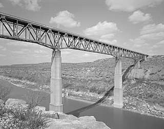
The Pecos River originates in north-central New Mexico and flows into Texas, emptying into the Rio Grande. Its headwaters are on the eastern slope of the Sangre de Cristo mountain range in Mora County north of Pecos, New Mexico, at an elevation of over 12,000 feet (3,700 m). The river flows for 926 miles (1,490 km) before reaching the Rio Grande near Del Rio. Its drainage basin encompasses about 44,300 square miles (115,000 km2).

The National Wild and Scenic Rivers System was created by the Wild and Scenic Rivers Actof 1968, enacted by the U.S. Congress to preserve certain rivers with outstanding natural, cultural, and recreational values in a free-flowing condition for the enjoyment of present and future generations.

The Virgin River is a tributary of the Colorado River in the U.S. states of Utah, Nevada, and Arizona. The river is about 162 miles (261 km) long. It was designated Utah's first wild and scenic river in 2009, during the centennial celebration of Zion National Park.

The Niobrara River is a tributary of the Missouri River, approximately 568 miles (914 km) long, running through the U.S. states of Wyoming and Nebraska. The river drains one of the most arid sections of the Great Plains, and has a low flow for a river of its length. The Niobrara's watershed includes the northern tier of Nebraska Sandhills, a small south-central section of South Dakota, as well as a small area of eastern Wyoming.

The Little Miami River is a Class I tributary of the Ohio River that flows 111 miles (179 km) through five counties in southwestern Ohio in the United States. The Little Miami joins the Ohio River east of Cincinnati. It forms parts of the borders between Hamilton and Clermont counties and between Hamilton and Warren counties. The Little Miami River is one of 156 American rivers designated by the U.S. Congress or the Secretary of the Interior as a National Wild and Scenic River and lends its name to the adjacent Little Miami Scenic Trail.
Olympic National Forest is a U.S. National Forest located in Washington, USA. With an area of 628,115 acres (2,541.89 km2), it nearly surrounds Olympic National Park and the Olympic Mountain range. Olympic National Forest contains parts of Clallam, Grays Harbor, Jefferson, and Mason counties. The landscape of the national forest varies, from the temperate Olympic rain forest to the salt water fjord of Hood Canal to the peaks of Mt. Washington.

The Maurice River ) is a tributary of Delaware Bay in Salem County and Cumberland County, New Jersey in the United States. The river was named for Maurice, Prince of Orange.

The Verde River is a major tributary of the Salt River in the U.S. state of Arizona. It is about 170 miles (270 km) long and carries a mean flow of 602 cubic feet per second (17.0 m3/s) at its mouth. It is one of the largest perennial streams in Arizona.

The National Trails System is a series of trails in the United States designated "to promote the preservation of, public access to, travel within, and enjoyment and appreciation of the open-air, outdoor areas and historic resources of the Nation". There are four types of trails: the national scenic trails, national historic trails, national recreation trails, and connecting or side trails. The national trails provide opportunities for hiking and historic education, as well as horseback riding, biking, camping, scenic driving, water sports, and other activities. The National Trails System consists of 11 national scenic trails, 21 national historic trails, over 1,300 national recreation trails, and seven connecting and side trails, as well as one national geologic trail, with a total length of more than 91,000 mi (150,000 km). The scenic and historic trails are in every state, and Virginia and Wyoming have the most running through them, with six.

Obed River is a stream draining a part of the Cumberland Plateau in Tennessee. It, and particularly its tributaries, are important streams for whitewater enthusiasts.

The Noatak River is a river in the northwestern part of the U.S. state of Alaska.
Whitewater or Wild water refers to rapids in rivers.
The Missouri National Recreational River is a National Recreational River located on the border between Nebraska and South Dakota. The designation was first applied in 1978 to a 59-mile section of the Missouri River between Gavins Point Dam and Ponca State Park. In 1991, an additional 39-mile section between Fort Randall Dam and Niobrara, Nebraska, was added to the designation. These two stretches of the Missouri River are the only parts of the river between Montana and the mouth of the Missouri that remain undammed or unchannelized. The last 20 miles of the Niobrara River and 6 miles of Verdigre Creek were also added in 1991.

The Bluestone National Scenic River protects a 10.5-mile (16.9 km) section of the Bluestone River in Summers and Mercer counties of southern West Virginia. It was created 26 October 1988 under the Wild and Scenic Rivers Act and is protected by the National Park Service.
The Upper Delaware Scenic and Recreational River is a unit of the National Park Service designated under the National Wild and Scenic Rivers System. It stretches along 73.4 miles (118.1 km) of the Delaware River between Hancock, New York, and Sparrowbush, New York. It includes parts of Delaware County, Orange County, and Sullivan County in New York, as well as Pike County and Wayne County in Pennsylvania. Most of the land in this unit is privately owned; the federal government only owns about 30 acres (12 ha).

The Florida Trail is one of eleven National Scenic Trails in the United States. It currently runs 1,500 miles (2,400 km), from Big Cypress National Preserve to Fort Pickens at Gulf Islands National Seashore, Pensacola Beach. Also known as the Florida National Scenic Trail, the Florida Trail provides permanent non-motorized recreation opportunity for hiking and other compatible activities and is within an hour of most Floridians. The Florida National Scenic Trail is designated as a National Scenic Trail by the National Trails System Act of 1968.

Smith River National Recreation Area is a protected area located in northwestern California, United States. The national recreation area is in Six Rivers National Forest and is managed by the U.S. Forest Service, an agency of the U.S. Department of Agriculture. Created by Congress in 1990, Smith River National Recreation Area meets the northern border of Redwood National and State Parks.

The Loxahatchee River is a 7.6 mile river near the southeast coast of Florida. It is a National Wild and Scenic River, one of only two in the state, and received its federal designation on May 17, 1985. The source of the Loxahatchee River is in Riverbend Park on the south side of Indiantown Road about 1.5 miles west of I-95 and Florida's Turnpike in Jupiter, Florida. The Loxahatchee River flows out of the Jupiter Inlet and into the Atlantic Ocean. This river was the inspiration for Florida film producer Elam Stoltzfus' 2005 project Our Signature: the Wild and Scenic Loxahatchee River, a film done in conjunction with the Loxahatchee River Preservation Initiative.

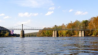
The Lower Delaware National Wild and Scenic River is a federally designated area of the Delaware River protected under the National Wild and Scenic Rivers System in Pennsylvania and New Jersey. The designation also includes sections of Paunnacussing Creek, Tohickon Creek, Tinicum Creek, Rapp Creek, and Beaver Creek. In total, the protection covers 67.3 miles (108.3 km) miles of waterways.


