Henry Hudson was an English sea explorer and navigator during the early 17th century, best known for his explorations of present-day Canada and parts of the northeastern United States.

The Barents Sea is a marginal sea of the Arctic Ocean, located off the northern coasts of Norway and Russia and divided between Norwegian and Russian territorial waters. It was known earlier among Russians as the Northern Sea, Pomorsky Sea or Murman Sea ; the current name of the sea is after the historical Dutch navigator Willem Barentsz.

Willem Barentsz, anglicized as William Barents or Barentz, was a Dutch navigator, cartographer, and Arctic explorer.

Spitsbergen is the largest and the only permanently populated island of the Svalbard archipelago in northern Norway.

The Muscovy Company was an English trading company chartered in 1555. It was the first major chartered joint-stock company, the precursor of the type of business that would soon flourish in England and finance its exploration of the world. The Muscovy Company had a monopoly on trade between England and Russia until 1698 and it survived as a trading company until the Russian Revolution. Since 1917, the company has operated as a charity, now working within Russia.

The Novaya Zemlya effect is a polar mirage caused by high refraction of sunlight between atmospheric thermal layers. The effect gives the impression that the sun is rising earlier than it actually should, and depending on the meteorological situation, the effect will present the Sun as a line or a square — sometimes referred to as the rectangular sun — made up of flattened hourglass shapes.
Steven Borough was an English navigator and an early Arctic explorer. He was master of the first English ship to reach the White Sea in 1553 and open trade with Russia on behalf of the Muscovy Company. He became an expert on piloting in Arctic waters and was one of the earliest English practitioners of the new scientific methods of navigation. He was widely sought out for his knowledge by English and Spanish mariners.

Richard Chancellor was an English explorer and navigator; the first to penetrate to the White Sea and establish relations with the Tsardom of Russia.

Sir Hugh Willoughby was an English soldier and an early Arctic voyager. He served in the court of Henry VIII and fought in the Scottish campaign where he was knighted for his valour. In 1553, he was selected by a company of London merchants to lead a fleet of three vessels in search of a Northeast Passage.

Jan Huygen van Linschoten was a Dutch merchant, traveller and writer.

Jacob van Heemskerck was a Dutch explorer and naval admiral. He is generally know for his victory over the Spanish at the Battle of Gibraltar, where he ultimately lost his life.

Cornelis Corneliszoon Nay was a Dutch navigator and explorer who attempted to discover the Northeast Passage from Europe to the Far East.

Elling Carlsen was a Norwegian skipper, seal hunter and explorer. He is credited with the discovery of Kong Karls Land and was one of the crew of the 1872 Austro-Hungarian North Pole Expedition. He is also known for the 1871 discovery of the lodge of Willem Barentsz, which had stood for 270 years since Barentsz sheltered there on his third and final voyage.

Richard Henry Major was a geographer and map librarian who curated the map collection of the British Museum from 1844 until his retirement in 1880.

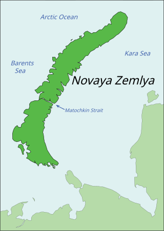
Novaya Zemlya is an archipelago in northern Russia. It is situated in the Arctic Ocean, in the extreme northeast of Europe, with Cape Flissingsky, on the northern island, considered the easternmost point of Europe. To Novaya Zemlya's west lies the Barents Sea and to the east is the Kara Sea.
During his 1553 voyage across the Barents Sea, English explorer Hugh Willoughby thought he saw islands to the north. Based on his description, these islands were subsequently depicted and named "Willoughby's Land" and "Macsinof Island" on maps published by Petrus Plancius in 1592 and 1594. Gerardus Mercator included them on his 1595 map. Willem Barentsz found no sign of Willoughby's discoveries and omitted them from his map published in 1599, but they continued to appear on Arctic maps published by Jan Janssonius and Willem Blaeu at least into the 1640s. Macsinof Island also appears as Macsin or Matsyn Island.

Arctic exploration is the physical exploration of the Arctic region of the Earth. It refers to the historical period during which mankind has explored the region north of the Arctic Circle. Historical records suggest that humankind have explored the northern extremes since 325 BC, when the ancient Greek sailor Pytheas reached a frozen sea while attempting to find a source of the metal tin. Dangerous oceans and poor weather conditions often fetter explorers attempting to reach polar regions, and journeying through these perils by sight, boat, and foot has proven difficult.
Nova Zembla is a 2011 Dutch historical drama film directed by Reinout Oerlemans. It is the first Dutch feature film in 3D.


