The North Fork Toutle River is a tributary of the Toutle River in southwestern Washington in the United States. The river has its headwaters near Spirit Lake, on the north side of Mount St. Helens, and flows 39 miles (63 km) to the Toutle River, about 17 miles (27 km) upstream of its confluence with the Cowlitz River. The largest tributary is the Green River, which joins near the unincorporated town of Toutle.

The Wind River is a tributary of the East Fork Chandalar River in the U.S. state of Alaska. It arises in the Philip Smith Mountains of the Brooks Range and flows into the East Fork and eventually into the Yukon River.
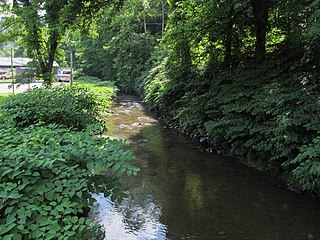
The East River is a tributary of the New River, 24 miles (39 km) long, in southern West Virginia and southwestern Virginia in the United States. Via the New, Kanawha and Ohio rivers, it is part of the watershed of the Mississippi River, draining an area of 76.4 square miles (198 km2) in the Ridge-and-Valley Appalachians.

The Trimbelle River is a 29.4-mile-long (47.3 km) tributary of the Mississippi River in western Wisconsin in the United States. It flows for its entire length in western Pierce County, rising in the town of Martell and flowing generally southwardly through the towns of River Falls, Trimbelle, Trenton and Diamond Bluff. It flows into the Mississippi River about 5 miles (8 km) west of Bay City.

The Yahara River is a tributary of the Rock River in southern Wisconsin in the United States. It is about 62 miles (100 km) long, and drains an area of 536 square miles (1,390 km2). Via the Rock River, it is part of the watershed of the Mississippi River. The Yahara River links the lakes around which the city of Madison was built.

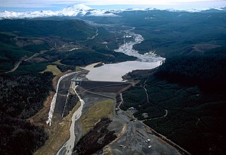
The White Salmon River is a 44-mile (71 km) tributary of the Columbia River in the U.S. state of Washington. Originating on the slopes of Mount Adams, it flows into the Columbia Gorge near the community of Underwood. Parts of the river have been designated Wild and Scenic. The principal tributaries of the White Salmon River include Trout Lake and Buck, Mill, Dry, Gilmer, and Rattlesnake Creeks.

The Wind River is a tributary of the Columbia River, in the U.S. state of Washington. Its entire course of 30 miles (48 km) lies within Skamania County. Crusattes River is an old variant name.

The Puerco River or Rio Puerco is a tributary of the Little Colorado River in northwestern New Mexico and northeastern Arizona. It flows through arid terrain, including the Painted Desert.

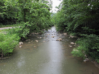
Elkhorn Creek is a 7.6-mile (12 km) long stream in Marion County, Oregon, United States. Its source is on the northern edge of the Willamette National Forest, about 3.5 miles (5.6 km) north of Big Cliff Reservoir. The creek flows mostly west, receiving Big Twelve Creek, Buckhorn Creek, and Buck Creek all from the south, and it enters the Little North Santiam River just south of Elkhorn Woods Park, about 5 miles (8.0 km) north of the city of Gates. The stream's valley is surrounded by the western Cascade foothills, covered with coniferous trees characteristic of the Pacific Northwest, and lined with red alders at the water's edge. The creek supports runs of rainbow and coastal cutthroat trout, as well as Pacific giant salamanders. On September 30, 1996, a 6.4-mile (10.3 km) portion of the stream, from the mouth nearly to the source, was protected as part of the National Wild and Scenic Rivers System.
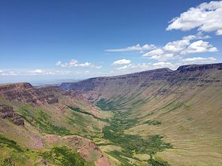
Kiger Creek is a tributary of Swamp Creek in Harney County in the U.S. state of Oregon. It originates on Steens Mountain and flows generally north through Kiger Gorge to meet Swamp Creek near the unincorporated community of Diamond. The combined streams flow into Diamond Swamp and the Malheur National Wildlife Refuge.

Armstrong Creek is a tributary of the Kanawha River, 8.6 miles (13.8 km) long, in southern West Virginia in the United States. Via the Kanawha and Ohio rivers, it is part of the watershed of the Mississippi River, draining an area of 22.8 square miles (59 km2) on the unglaciated portion of the Allegheny Plateau. The creek flows for its entire length in western Fayette County; its tributaries additionally drain a small portion of eastern Kanawha County.

Loop Creek, also known by the spelling Loup Creek, is a tributary of the Kanawha River, 20 miles (32 km) long, in southern West Virginia in the United States. Via the Kanawha and Ohio rivers, it is part of the watershed of the Mississippi River, draining an area of 49.6 square miles (128 km2) in a coal mining region on the unglaciated portion of the Allegheny Plateau.
Smithers Creek is a tributary of the Kanawha River, 7 miles (11 km) long, in southern West Virginia in the United States. Via the Kanawha and Ohio rivers, it is part of the watershed of the Mississippi River, draining an area of 18.1 square miles (47 km2) on the unglaciated portion of the Allegheny Plateau. The creek flows for its entire length in western Fayette County; its tributaries additionally drain a portion of eastern Kanawha County.

Kellys Creek is a tributary of the Kanawha River, 6.5 miles (10.5 km) long, in West Virginia in the United States. Via the Kanawha and Ohio rivers, it is part of the watershed of the Mississippi River, draining an area of 24.7 square miles (64 km2) in a coal mining region on the unglaciated portion of the Allegheny Plateau.
Witcher Creek is a tributary of the Kanawha River, 6.8 miles (10.9 km) long, in West Virginia in the United States. Via the Kanawha and Ohio rivers, it is part of the watershed of the Mississippi River, draining an area of 20.8 square miles (54 km2) on the unglaciated portion of the Allegheny Plateau.
Campbells Creek is a tributary of the Kanawha River, 18.5 miles (29.8 km) long, in West Virginia in the United States. Via the Kanawha and Ohio rivers, it is part of the watershed of the Mississippi River, draining an area of 39.3 square miles (102 km2) on the unglaciated portion of the Allegheny Plateau, in the Charleston metropolitan area.

Arnold Creek is a tributary of Middle Island Creek, 10.9 miles (17.5 km) long, in West Virginia in the United States. Via Middle Island Creek and the Ohio River, it is part of the watershed of the Mississippi River, draining an area of 34.7 square miles (90 km2) in a rural region on the unglaciated portion of the Allegheny Plateau.

Flint Run is a tributary of McElroy Creek, 7.5 miles (12.1 km) long, in northern West Virginia in the United States. Via McElroy Creek, Middle Island Creek, and the Ohio River, it is part of the watershed of the Mississippi River, draining an area of 25.6 square miles (66 km2) in a rural region on the unglaciated portion of the Allegheny Plateau.

Point Pleasant Creek is a tributary of Middle Island Creek, 10.4 miles (16.7 km) long, in northwestern West Virginia in the United States. Via Middle Island Creek and the Ohio River, it is part of the watershed of the Mississippi River, draining an area of 60.5 square miles (157 km2) in a rural region on the unglaciated portion of the Allegheny Plateau.