The Kanangra-Boyd National Park is a protected national park that is located in the Central Tablelands region, west of the Southern Highlands and Macarthur regions, in New South Wales, in eastern Australia. The 68,660-hectare (169,700-acre) national park is situated approximately 180 kilometres (110 mi) south-west of Sydney and is contiguous with the Blue Mountains National Park and the Nattai National Park. The park was established in 1969.
Danggu (Geikie) Gorge National Park is a national park in the Kimberley region of Western Australia, 1,837 kilometres (1,141 mi) northeast of Perth and approximately 420 km (261 mi) east of Broome by road. The gorge was originally named in honour of Sir Archibald Geikie, the Director General of Geological Survey for Great Britain and Ireland when it was given its European name in 1883. Sir Archibald never visited the gorge and the National Park is progressively being officially changed to the Bunuba traditional owners name of Danggu.

The Purnululu National Park is a World Heritage Site in the East Kimberley region of Western Australia. The 239,723-hectare (592,370-acre) national park is located approximately 300 kilometres (190 mi) south of Kununurra, with Halls Creek located to the south. Declared a World Heritage Site in 2003, the park was inscribed as follows:
...[is a] remote area managed as wilderness. It includes the Bungle Bungle Range, a spectacularly incised landscape of sculptured rocks which contains superlative examples of beehive-shaped karst sandstone rising 250 metres above the surrounding semi-arid savannah grasslands. Unique depositional processes and weathering have given these towers their spectacular black and orange banded appearance, formed by biological processes of cyanobacteria which serve to stabilise and protect the ancient sandstone formations. These outstanding examples of cone karst that have eroded over a period of 20 million years are of great beauty and exceptional geological interest.

Tunnel Creek National Park is a national park in the Kimberley region of Western Australia, 1,845 kilometres (1,146 mi) northeast of Perth and 390 km (240 mi) east of Broome. The natural cave through which Tunnel Creek flows is a major attraction of the park.

Windjana Gorge National Park is a national park in the Kimberley region of Western Australia, 1855 km northeast of Perth and 355 km east of Broome. Open during the dry season only - usually April to November.

The Kimberley is the northernmost of the nine regions of Western Australia. It is bordered on the west by the Indian Ocean, on the north by the Timor Sea, on the south by the Great Sandy and Tanami Deserts in the region of the Pilbara, and on the east by the Northern Territory.
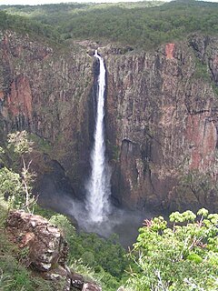
The Wallaman Falls, a cascade and horsetail waterfall on the Stony Creek, is located in the UNESCO World Heritage–listed Wet Tropics in the locality of Wallaman, Shire of Hinchinbrook in the northern region of Queensland, Australia. The waterfall is notable for its main drop of 268 metres (879 ft), which makes it the country's tallest single-drop waterfall. The pool at the bottom of the waterfall is 20 metres (66 ft) deep. An estimated 100,000 people visit the waterfall annually.

The Gibb River Road is a road in the Kimberley region of Western Australia.

Fitzroy Crossing is a small town in the Kimberley region of Western Australia, 400 kilometres (250 mi) east of Broome and 300 kilometres (190 mi) west of Halls Creek. It is approximately 2,524 kilometres (1,568 mi) from the state capital of Perth.
Jandamarra or Tjandamurra, known to European settlers as Pigeon, was an Indigenous Australian of the Bunuba tribe who led one of many organised armed insurrections against the European colonisation of Australia. Initially utilised as a tracker for the police, he became a fugitive when he was forced to capture his own people. He led a three-year campaign against police and European settlers, achieving legendary status for his hit and run tactics and his abilities to hide and disappear. Jandamarra was eventually killed by another tracker at Tunnel Creek on 1 April 1897. His body was buried by his family at the Napier Range where it was placed inside a boab tree. Jandamarra's life has been the subject of two novels, Ion Idriess's Outlaws of the Leopold (1952) and Mudrooroo's Long Live Sandawarra (1972), and a stage play.

The King Leopold Ranges are a range of hills in the western Kimberley region of Western Australia. The range was named on 6 June 1879 by the explorer Alexander Forrest, during an expedition in the Kimberley area, after King Leopold II of Belgium, "for the great interest taken by His Majesty in exploration".

The Napier Ranges are located in the Kimberley region of Western Australia. The range is south of and runs parallel to the King Leopold Range.

Tunnel Creek is a creek located within the grounds of Tunnel Creek National Park in the Kimberley Region of Western Australia. Along with Geikie Gorge and Windjana Gorge, Tunnel Creek is part of an ancient barrier reef that developed during the Devonian Period. Tunnel Creek is located 63 kilometres from the Great Northern Highway, between Derby and Fitzroy Crossing, and was created by waters from a creek that cut a 750-metre tunnel through the reef. The tunnel is 15 metres wide and up to 12 metres high. Tunnel Creek was also the hideout for the Bunuba man Jandamarra, also known as Pigeon, who was killed there by police in 1897.

Lennard River is a river in the Kimberley region of Western Australia. The river was named on 8 June 1879 by the explorer Alexander Forrest, during an expedition in the Kimberley area, after Amy Eliza Barrett-Lennard (1852-1897), whom he was to marry on 15 January 1880.
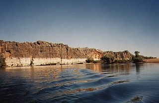
Geikie Gorge is a feature of the Napier Range and is located within the grounds of Danggu Gorge National Park, 20 kilometres (12 mi) from Fitzroy Crossing, 1,831 km (1,138 mi) northeast of Perth and 420 km (260 mi) east of Broome in the Kimberley Region of Western Australia. Believed to be one of the best-known and most easily accessed, the gorge is named in honour of Sir Archibald Geikie, the Director General of Geological Survey for Great Britain and Ireland when it was given its European name in 1883.
The Richenda River is a river in the Kimberley of Western Australia.
The Bunuba are a group of Indigenous Australians and are one of the traditional owners of the southern West Kimberley, in Western Australia. Many now live in and around the town of Fitzroy Crossing.
Jandamarra's War is a 2011 Australian drama style documentary that tells the story of Jandamarra, a famous Aboriginal Australian warrior of the Bunuba people from Western Australia.
Devonian Reef is located in the Kimberley region in an area once covered by tropical sea. It is now a protected area of Western Australia and includes three National Parks, the Geikie Gorge National Park, the Tunnel Creek National Park and the Windjana Gorge National Park. All the parks originated as the Western Australia reef, around 350 million years ago, during the Devonian Period, and now feature rocky landscapes and formation, rich gorges, and plenty of wildlife.. The three ranges cut through the Devonian "Great Barrier Reef" and is now exposed to reveal some of the most spectacular landforms in the Kimberley Region.
The Unggumi, also written Ongkomi, are an indigenous Australian people of the Kimberley region of Western Australian.