Winner Regional Airport

Last updated

Coordinates: 43°23′25″N099°50′32″W / 43.39028°N 99.84222°W / 43.39028; -99.84222

Geographic coordinate system Coordinate system

A geographic coordinate system is a coordinate system that enables every location on Earth to be specified by a set of numbers, letters or symbols. The coordinates are often chosen such that one of the numbers represents a vertical position and two or three of the numbers represent a horizontal position; alternatively, a geographic position may be expressed in a combined three-dimensional Cartesian vector. A common choice of coordinates is latitude, longitude and elevation. To specify a location on a plane requires a map projection.

Contents

Winner Regional Airport
Bob Wiley Field
Summary
Airport type Public
Owner City of Winner
Serves Winner, South Dakota
Elevation  AMSL 2,032 ft / 619 m
Runways
Direction Length Surface
ft m
13/31 4,500 1,372 Concrete
3/21 2,900 884 Turf
Statistics (2007)
Aircraft operations 19,800

Winner Regional Airport( ICAO : KICR, FAA LID : ICR), also known as Bob Wiley Field, is a public airport located one mile (2 km) northeast of the central business district of Winner, a city in Tripp County, South Dakota, United States. The airport is owned by the City of Winner. [1] The airport's FAA location identifier, formerly SFD, was changed on July 5, 2007. [2]

ICAO airport code four-letter code designating many airports around the world

The ICAOairport code or location indicator is a four-letter code designating aerodromes around the world. These codes, as defined by the International Civil Aviation Organization and published in ICAO Document 7910: Location Indicators, are used by air traffic control and airline operations such as flight planning.

Federal Aviation Administration United States Government agency dedicated to civil aviation matters

The Federal Aviation Administration (FAA) is a governmental body of the United States with powers to regulate all aspects of civil aviation in that nation as well as over its surrounding international waters. Its powers include the construction and operation of airports, air traffic management, the certification of personnel and aircraft, and the protection of U.S. assets during the launch or re-entry of commercial space vehicles. Powers over neighboring international waters were delegated to the FAA by authority of the International Civil Aviation Organization.

A location identifier is a symbolic representation for the name and the location of an airport, navigation aid, or weather station, and is used for manned air traffic control facilities in air traffic control, telecommunications, computer programming, weather reports, and related services.

Facilities and aircraft

Winner Regional Airport covers an area of 226 acre s (91  ha ) which contains two runways: 13/31 which has a concrete pavement measuring 4,500 x 75 ft (1,372 x 23 m) and 3/21 with a turf surface measuring 2,900 x 150 ft (884 x 46 m). For the 12-month period ending June 13, 2007, the airport had 19,800 aircraft operations, an average of 54 per day: 98% general aviation and 2% air taxi. [1]

Acre unit of area

The acre is a unit of land area used in the imperial and US customary systems. It is traditionally defined as the area of one chain by one furlong, which is exactly equal to 10 square chains, ​1640 of a square mile, or 43,560 square feet, and approximately 4,047 m2, or about 40% of a hectare. Based upon the International yard and pound agreement of 1959, an acre may be declared as exactly 4,046.8564224 square metres. The acre is a statute measure in the United States and was formerly one in the United Kingdom and almost all countries of the former British Empire, although informal use continues.

Hectare metric unit of area

The hectare is an SI accepted metric system unit of area equal to a square with 100-metre sides, or 10,000 m2, and is primarily used in the measurement of land. There are 100 hectares in one square kilometre. An acre is about 0.405 hectare and one hectare contains about 2.47 acres.

Runway Area of surface used by aircraft to takeoff from and land on

According to the International Civil Aviation Organization (ICAO), a runway is a "defined rectangular area on a land aerodrome prepared for the landing and takeoff of aircraft". Runways may be a man-made surface or a natural surface.

Related Research Articles

Lawrence J. Timmerman Airport Airport in Wisconsin, United States of America

Lawrence J. Timmerman Airport, known locally as Timmerman Field, is an airport in Milwaukee, Wisconsin, United States, owned by Milwaukee County. Located 5 miles (8 km) northwest of the city center, it is used mainly for general or private aviation. It is included in the Federal Aviation Administration (FAA) National Plan of Integrated Airport Systems for 2019–2023, in which it is categorized as a regional reliever airport facility.

Watertown Municipal Airport (Wisconsin) airport in Wisconsin, United States of America

Watertown Municipal Airport is a public use airport located in and owned by the city of Watertown, in Jefferson County, Wisconsin, United States. It is included in the Federal Aviation Administration (FAA) National Plan of Integrated Airport Systems for 2019–2023, in which it is categorized as a regional general aviation facility.

Coffey County Airport is a county-owned public-use airport located seven miles (11 km) north of the central business district of Burlington, a city in Coffey County, Kansas, United States.

Hutchinson Municipal Airport (Minnesota) airport in Hutchinson, United States of America

Hutchinson Municipal Airport, also known as Butler Field, is a public airport located two miles (3 km) south of the central business district of Hutchinson, a city in McLeod County, Minnesota, United States. It is owned by the City of Hutchinson. The airport is home to the Civil Air Patrol. The FBO is operated by ASI JET.

Waukesha County Airport airport in Wisconsin, United States of America

'Waukesha County Airport/Crites Field, is a public use airport located two miles (3 km) north of the central business district of Waukesha, a city in Waukesha County, Wisconsin, United States. It is owned and operated by Waukesha County. It is included in the Federal Aviation Administration (FAA) National Plan of Integrated Airport Systems for 2019–2023, in which it is categorized as a national reliever aviation facility.

Nenana Municipal Airport airport in Alaska, United States of America

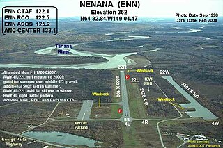
Nenana Municipal Airport is a city-owned public-use airport located one mile (1.6 km) south of the central business district of Nenana, a city in the Yukon-Koyukuk Census Area of the U.S. state of Alaska.

Skyhaven Airport is a public-use airport located three miles (5 km) northwest of the central business district of Warrensburg, a city in Johnson County, Missouri, United States. It is owned by the University of Central Missouri.

Skagit Regional Airport is a public airport located three miles (5 km) west of the central business district of Burlington and northwest of Mount Vernon, both cities in Skagit County, Washington, United States. The airport is owned by the Port of Skagit County. It is situated in the Bayview Industrial Park.

Dalton Municipal Airport is a city-owned public-use airport located six miles (10 km) southeast of the central business district of Dalton, a city in Whitfield County, Georgia, United States.

Hartness State Airport airport in Springfield (CDP), Vermont, United States of America

Hartness State Airport is a public airport located three miles (5 km) northwest of the central business district of Springfield, a town in Windsor County, Vermont, United States. It is owned by the State of Vermont.

Rawlins Municipal Airport is a public airport two miles (3 km) northeast of Rawlins, in Carbon County, Wyoming. The Rawlins Carbon County Airport Board owns it.

Leesburg International Airport

Leesburg International Airport, formerly known as Leesburg Regional Airport, is a public airport located three miles (5 km) northeast of the central business district of Leesburg, a city in Lake County, Florida, United States. It is owned by the City of Leesburg.

Wharton Regional Airport airport in Texas, United States of America

Wharton Regional Airport is a public airport located five miles (8 km) southwest of the central business district of Wharton, a city in Wharton County, Texas, United States. It is owned by the City of Wharton.

Monticello Regional Airport airport in Iowa, United States of America

Monticello Regional Airport, formerly known as Monticello Municipal Airport, is a public airport located two miles (3 km) southeast of the central business district of Monticello, a city in Jones County, Iowa, United States. It is owned by the City of Monticello.

Hobart Regional Airport is three miles southeast of Hobart, in Kiowa County, Oklahoma.

La Porte Municipal Airport (Indiana) airport

La Porte Municipal Airport is a city-owned public-use airport located three miles (5 km) south of the central business district of La Porte, a city in La Porte County, Indiana, United States.

Willmar Municipal Airport airport in Willmar, United States of America

Willmar Municipal Airport, also known as John L. Rice Field, is a city-owned public-use airport located west of the central business district of Willmar, a city in Kandiyohi County, Minnesota, United States. The airport opened in 2006 and is located two miles west of a closed airport which operated under the same name.

Mason County Airport (Michigan) airport

Mason County Airport is a county-owned public-use airport located two miles (3 km) northeast of the central business district of Ludington, a city in Mason County, Michigan, United States.

Skyhaven Airport (New Hampshire) airport in New Hampshire, United States of America

Skyhaven Airport is a public-use airport located three miles (5 km) southeast of the central business district of Rochester, a city in Strafford County, New Hampshire, United States. The airport is owned and operated by the Pease Development Authority, with fixed-base operator (FBO) services provided by Skyhaven Aviation Services. It is included in the Federal Aviation Administration (FAA) National Plan of Integrated Airport Systems for 2017–2021, in which it is categorized as a local general aviation facility.

Northeast Iowa Regional Airport airport in Iowa, United States of America

Northeast Iowa Regional Airport is a public airport located three miles (5 km) east of the central business district of Charles City, in Floyd County, Iowa, United States. It is owned by the North Cedar Aviation Authority and was formerly known as Charles City Municipal Airport.

References

  1. 1 2 3 FAA Airport Master Record for ICR ( Form 5010 PDF ), effective 2007-10-25
  2. "Technical Implementation Notice 07-44". National Weather Service. 2007-06-29.

The kibibyte is a multiple of the unit byte for quantities of digital information. The binary prefix kibi means 210, or 1024; therefore, 1 kibibyte is 1024 bytes. The unit symbol for the kibibyte is KiB.