
Northglenn is a Home Rule Municipality in Adams and Weld counties in the U.S. state of Colorado. As of the 2010 census the city's population was 35,789. It was built as a master planned community in 1959 by Jordon Perlmutter.

The Borough of Fylde is a local government district with borough status in Lancashire, England. It covers part of the Fylde plain, after which it is named. The council's headquarters are in St Annes. Some council departments, including Planning and an office of the Registrar, were previously located in Wesham, but in 2007 these offices were transferred to the ownership of the NHS North Lancashire Primary Care Trust and have since been replaced by a new housing development. The population of the Non-metropolitan district at the 2011 census was 75,757.

The Borough of Newcastle-under-Lyme is a local government district with borough status in Staffordshire, England.

The River Dean rises at Longclough in Macclesfield Forest on the western edge of the Peak District foothills above the village of Rainow in north east Cheshire, England.
Hazel Grove and Bramhall was a civil parish and urban district in north east Cheshire, England from 1900 to 1974.
Wolstanton was a rural district in Staffordshire, England from 1894 to 1904. It was created by the Local Government Act 1894 based on Wolstanton rural sanitary district.
Stockport was a rural district in the administrative county of Cheshire from 1894 to 1904. The district was the successor to the Stockport Rural Sanitary District formed in 1875.
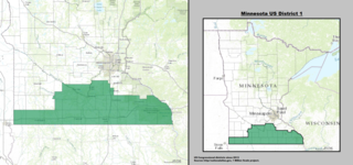
Minnesota's 1st congressional district extends across southern Minnesota from the border with South Dakota to the border with Wisconsin. The First District is primarily a rural district built on a strong history of agriculture, although this is changing rapidly due to strong population growth in Rochester and surrounding communities. The First District is also home to several of Minnesota's major mid-sized cities, including Rochester, Mankato, Winona, Austin, Owatonna, Albert Lea, New Ulm, and Worthington. This district is currently represented by Republican Jim Hagedorn of Blue Earth.
Lees was from 1894 to 1974, a local government district in the administrative county of Lancashire, England.

Wolstanton is a suburban village on the outskirts of Newcastle-under-Lyme, Staffordshire.

Fylde South was a constituency which returned one Member of Parliament to the House of Commons of the Parliament of the United Kingdom from 1950, until it was abolished for the 1983 general election.

Oklahoma's fifth congressional district is a congressional district in the U.S. state of Oklahoma. It borders all of the other congressional districts in the state except the 1st District. It is densely populated and covers almost all of Oklahoma County and all of Pottawatomie and Seminole counties.
Huyton with Roby Urban District was a local government district in Lancashire, England from 1894 to 1974. It consisted of the civil parish of Huyton with Roby which comprised the settlements of Huyton and Roby. It replaced the Huyton with Roby urban sanitary district.
Wolstanton ward is a ward in the Borough of Newcastle-under-Lyme. It covers the suburbs of Dimsdale and Wolstanton.
Kidsgrove Urban District was an urban district in the county of Staffordshire. It was formed in 1894 with the civil parishes of Hardings Wood, Kidsgrove, Newchapel and Talke. It was abolished in 1974, by virtue of the Local Government Act 1972, when it was absorbed into the Borough of Newcastle-under-Lyme.

Milton Township is one of nine townships in DuPage County, Illinois, USA. As of the 2010 census, its population was 117,067 and it contained 45,153 housing units.

The geography of Greater Manchester is dominated by one of the United Kingdom's largest metropolitan areas, and in this capacity the landlocked metropolitan county constitutes one of the most urbanised and densely populated areas of the country. There is a mix of high density urban areas, suburbs, semi-rural and rural locations in Greater Manchester, but overwhelmingly the land use in the county is urban.

Highland Township is one of five townships in Vermillion County, Indiana, United States. As of the 2010 census, its population was 1,534 and it contained 724 housing units.

Chell is a suburb of the city of Stoke-on-Trent in Staffordshire, England, that can be subdivided into Little Chell, Great Chell and Chell Heath. It lies on the northern edge of the city, approximately 1 mile from Tunstall, 2 miles from Burslem and 3 miles from Cheshire. Chell borders Pitts Hill to the west, Tunstall to the south west, Stanfield and Bradeley to the south, with the outlying villages of Packmoor and Brindley Ford to the north and Ball Green to the east. Since 2011 the area has been divided into the electoral wards of Bradeley & Chell Heath, Great Chell & Packmoor and Little Chell & Stanfield.
Wolstanton High School, previously known as Wolstanton Grammar School, is a high school in Newcastle-under-Lyme, Staffordshire.

