
A biotope is an area of uniform environmental conditions providing a living place for a specific assemblage of plants and animals. Biotope is almost synonymous with the term habitat, which is more commonly used in English-speaking countries. However, in some countries these two terms are distinguished: the subject of a habitat is a population, the subject of a biotope is a biocoenosis or biological community.
A buffer zone is a neutral zonal area that lies between two or more bodies of land, usually pertaining to countries. Depending on the type of buffer zone, it may serve to separate regions or conjoin them. Common types of buffer zones are demilitarized zones, border zones and certain restrictive easement zones and green belts. Such zones may be comprised by a sovereign state, forming a buffer state.

The Gloucestershire Wildlife Trust is the Gloucestershire local partner in a conservation network of 46 Wildlife Trusts. The Wildlife Trusts are local charities with the specific aim of protecting the United Kingdom's natural heritage. The Gloucestershire Wildlife Trust is managed by a Board of Trustees elected from its membership who provide overall direction for the development of the Trust and there are Advisory Committees. The work of the trust is carried out through staff and volunteers.

In ecology, the term habitat summarises the array of resources, physical and biotic factors that are present in an area, such as to support the survival and reproduction of a particular species. A species habitat can be seen as the physical manifestation of its ecological niche. Thus, habitat is a species-specific term, fundamentally different from concepts such as environment or vegetation assemblages, for which the term habitat-type is more appropriate.

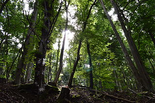
Homburg Castle is an old hill castle in Nümbrecht, Oberbergischer Kreis in the German state of North Rhine-Westphalia.

The Mainz Sand Dunes are a small geological and botanical supra-region and important nature preserve in Mainz, Germany. Within this protected area rare plants and animals can be found. Some of the species represented here, such as the Purple Golden-drop, grow only here and in small numbers.

The environment of Azerbaijan, includes a wide diversity of climates, animals, plants, and habitats.

Sevenoaks Gravel Pits is a 73.7-hectare (182-acre) biological Site of Special Scientific Interest on the northern outskirts of Sevenoaks in Kent. It is managed by Kent Wildlife Trust as the Sevenoaks Wildlife Reserve and Jeffery Harrison Visitor Centre.

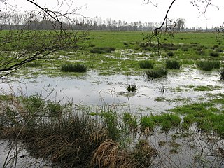
A pond is an area filled with water, either natural or artificial, that is smaller than a lake. Ponds may arise naturally in floodplains as part of a river system or can simply be an isolated depression that filled with runoff, groundwater, or precipitation. As such, ponds may be freshwater, saltwater, or brackish in nature.

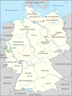
Germany is a country in west-central Europe, that stretches from the Alps, across the North European Plain to the North Sea and the Baltic Sea. Germany has the second largest population in Europe and is seventh largest in area. The territory of Germany covers 357,021 km2 (137,847 sq mi), consisting of 349,223 km2 (134,836 sq mi) of land and 7,798 km2 (3,011 sq mi) of waters.
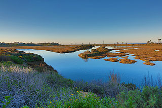
San Elijo Lagoon Ecological Reserve is one of the largest remaining coastal wetlands in San Diego County, California, United States.
The German Federal Agency for Nature Conservation is the German government's scientific authority with responsibility for national and international nature conservation. BfN is one of the government's departmental research agencies and reports to the German Environment Ministry (BMU).

Ham Wall is an English wetland National Nature Reserve (NNR) 4 kilometres (2.5 mi) west of Glastonbury on the Somerset Levels. It is managed by the Royal Society for the Protection of Birds (RSPB). Since the last Ice Age, decomposing plants in the marshes of the Brue valley in Somerset have accumulated as deep layers of peat that were commercially exploited on a large scale in the twentieth century. Consumer demand eventually declined, and in 1994 the landowners, Fisons, gave their old workings to what is now Natural England, who passed the management of the 260 hectares Ham Wall section to the RSPB.

The Große Aue is an 88-kilometre-long (55 mi), southwestern, left tributary of the River Weser in northern North Rhine-Westphalia and central Lower Saxony in Germany.
The Oppenwehe Moor is a raised bog in the natural region of Diepholz Moor Depression in North Germany. It covers a total area of around 870 ha and lies in the northeastern part of the German state of North Rhine-Westphalia as well as in Lower Saxony. It is one of the most important bogs in Northwest Germany and is one of the ten most important wet meadow reserves in North Rhine-Westphalia. It is part of the Dümmer Nature Park.

The Teutoburg Forest / Egge Hills Nature Park is a nature park founded in 1965 in the northeast of the German state of North Rhine-Westphalia. After being expanded in 2008, the nature park is now the largest in Germany, covering an area of 2,700 km2. The park comprise the southern Teutoburg Forest and Egge Hills.

The Obersee is the smaller of the two parts of Zürichsee in the cantons of St. Gallen and Schwyz in Switzerland.
The Maas-Schwalm-Nette Nature Park or NMSM is a cross-border nature park in Germany and the Netherlands, which was founded in 2002. It is a regionally important recreation area.
Münstereifel Forest is densely wooded region in the northern part of the Eifel mountains in North Rhine-Westphalia, Germany. In the south it borders on the state of Rhineland-Palatinate. It has an area of 237 km² and lies at a height of between 200 and 500 m above sea level (NHN).
The Rhine delta of Lake Constance is the river delta on the southeastern shore of Lake Constance, which the Rhine has formed in a former sea area. It lies mostly in the Austrian province of Vorarlberg, smaller areas are in the Swiss canton of St. Gallen. The two peninsulas in the lake are called Rheinspitz (west) and Rohrspitz (east).
