Conception Harbour is a town on the Avalon Peninsula in Newfoundland and Labrador, Canada. It is in Division 1 on Conception Bay and can be accessed via Newfoundland and Labrador Route 60.
Division No. 1, Subdivision A is an unorganized subdivision on the Avalon Peninsula in Newfoundland and Labrador, Canada. It is in Division No. 1, and lies between Trinity Bay and Placentia Bay.
Anue is a town and municipality located in the province and autonomous community of Navarre, northern Spain.

Arellano is a town and municipality located in the province and autonomous community of Navarre, northern Spain.
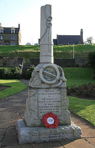
The Eyemouth disaster was a severe European windstorm that struck the south-eastern coast of Scotland on 14 October 1881. One hundred and eighty-nine fishermen, most of whom were from Eyemouth, were drowned. Many citizens of Eyemouth call the day Black Friday.
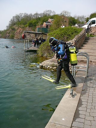
Stoney Cove is a large flooded quarry which is a popular inland scuba diving site, located between Stoney Stanton and Broughton Astley in Leicestershire, England.
Oregon Jack Provincial Park is a provincial park in British Columbia, Canada located in the Clear Range west of Ashcroft. It protects the limestone canyon of Oregon Jack Creek, at the head of which is a waterfall named the Notch, above which is included a wetland area. The site was an important First Nations site and there are pictographs, culturally modified trees and a site known as the Three Sisters Rock Shelter.
Fortune Bay is a fairly large natural bay located in the Gulf of St. Lawrence on the south coast of Newfoundland, Canada. The Bay is bounded by Point Crewe on the Burin Peninsula and Pass Island at the entrance to Hermitage Bay to the northwest for a distance of 56 kilometers. The bay extends in a northeast direction for 105 kilometers ending at Terrenceville.
Miles Cove is a town on Sunday Cove Island in the Canadian province of Newfoundland and Labrador. The town had a population of 104 in 2016, down from 140 in the Canada 2006 Census.

St. Jacques-Coomb's Cove is a town in the Canadian province of Newfoundland and Labrador. The town had a population of 546 in the Canada 2021 Census. It is located on the south coast of the island of Newfoundland on the north side of Fortune Bay, on the southern tip of the Connaigre Peninsula in what is now known as the Coast of Bays Region. The town consists of six communities, St. Jacques, English Harbour West, Mose Ambrose, Boxey, Coomb's Cove, and Wreck Cove, all nestled within the inlets along the coast. They all had their beginnings in the fisheries and the fisheries have always been the mainstay of employment in the communities. In recent years aquaculture was introduced in the area, providing employment for its residents.
The Connaigre Peninsula is a Canadian peninsula located on the south coast of the island of Newfoundland in the province of Newfoundland and Labrador. Harbour Breton is the largest population centre on the peninsula.
Rue is an unincorporated community in Accomack County, Virginia.
Stanegarth was built in 1910 as a steam-powered tugboat by Lytham Ship Builders Company for service with the British Waterways Board. She was converted to diesel power in 1957. The tug used to tow three dredging hoppers, each crewed by two men, on the trip to and from Gloucester to Purton.
Seyidmahmudlu is a village in the Fuzuli District of Azerbaijan.
Hampstead is an unincorporated community in New Kent County, Virginia, United States.

Livadia was an imperial yacht of the House of Romanov built in 1869–1873 by Leopold Schwede in Nikolaev. She served on the Black Sea. The Livadia was the only Russian imperial yacht that has seen active combat service during the Russo-Turkish war of 1877–1878. October 21–22, 1878 she ran aground near Cape Tarkhan-Kut in Crimea and sank.

Boil Point is the point forming the west side of the entrance to Retizhe Cove on the south coast of Trinity Peninsula in Graham Land, Antarctica.
Frenchman's Cove Provincial Park, is a provincial park located on the west side of the Burin Peninsula in Newfoundland and Labrador, Canada.

Yerba Buena Cove was a cove on San Francisco Bay where the Mexican pueblo of Yerba Buena was located. It lay between Clarks Point to the north and Rincon Point to the south. The beach of the cove was set back as far as what is now Montgomery Street between Clay and Washington Streets.
Umpire is an unincorporated community in southwestern Wright County, in the U.S. state of Missouri.
This page is based on this
Wikipedia article Text is available under the
CC BY-SA 4.0 license; additional terms may apply.
Images, videos and audio are available under their respective licenses.
