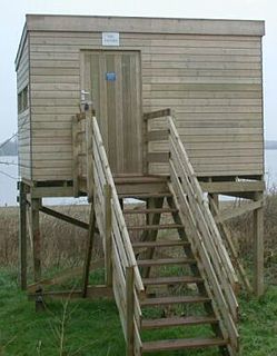
Belvide Reservoir is a reservoir in South Staffordshire, England. It was built in 1833 to supply the Birmingham and Liverpool Junction Canal, and has been managed as a nature reserve since 1977. It has been used to study the effect of water level changes on bird populations.

The River Rea is a small river which passes through Birmingham, England. It is the river on which Birmingham was founded by the Beorma tribe in the 7th century.

The River Tame is the main river of the West Midlands of England, and one of the principal tributaries of the River Trent. The Tame is about 95 km (59 mi) long from the source at Oldbury to its confluence with the Trent near Alrewas, but the main river length of the entire catchment, i.e. the Tame and its main tributaries, is about 285 km (177 mi).

The River Cole is a 25 miles (40 km) river in the English Midlands. It rises on the lower slopes of Forhill, one of the south-western ramparts of the Birmingham Plateau, at Red Hill and flows south before flowing largely north-east across the plateau to enter the River Blythe below Coleshill, near Ladywalk, shortly before the Blythe meets the Tame. This then joins the Trent, whose waters reach the North Sea via the Humber Estuary. Its source is very near the main watershed of Midland England : tributaries are few and very short except in the lower reaches, so the Cole is only a small stream.
Chasewater is a reservoir located in the parish of Burntwood and the district of Lichfield in Staffordshire, England. Originally known as Norton Pool and Cannock Chase Reservoir, it was created as a canal feeder reservoir in 1797. The reservoir was created to directly supply the Wyrley and Essington Canal and maintain levels in the 160-mile (260 km) Birmingham Canal Network. During a period of great industrial growth in the Black Country region the maintenance of water levels in canal infrastructure was essential and Chasewater was in great demand. As canals became less essential for transport of goods during the mid-20th century, the reservoir diversified and became a popular public amenity with activities such as water-skiing, sailing, wakeboarding and cycling. Chasewater is the third largest reservoir by volume in the county of Staffordshire and the largest canal feeder reservoir in the West Midlands.

Northfield is a small town and also a small residential area on the southern outskirts of metropolitan Birmingham, England, and near the boundary with Worcestershire. It is also a council constituency, managed by its own district committee. The constituency includes the wards of Kings Norton, Longbridge, Weoley Castle and the smaller ward of Northfield that includes West Heath and Turves Green.

The Worcester and Birmingham Canal is a canal linking Birmingham and Worcester in England. It starts in Worcester, as an 'offshoot' of the River Severn and ends in Gas Street Basin in Birmingham. It is 29 miles (47 km) long. There are 58 locks in total on the canal, including the 30 Tardebigge Locks, one of the largest lock flights in Europe. The canal climbs 428 feet (130 m) from Worcester to Birmingham.
Stirchley is in the south west of Birmingham, England.

Moseley Bog, formerly The Dell, is a Local Nature Reserve in the Moseley area of Birmingham, England.

The name Rea Brook can refer to either of two brooks in Shropshire, England.

The Bittell Reservoirs are located in Worcestershire between Barnt Green to the south and the Birmingham district of Longbridge to the north. They consist of the Upper and Lower reservoir. They were built to feed the Worcester and Birmingham Canal, which was finished in the 1790s, however, the reservoir was not completed until 1837. The 'Upper' reservoir is to ensure that the level of the canal is kept sufficiently high, even in times of drought. The 'Lower' reservoir(s) are compensatory reservoirs to ensure that the local area does not become parched in dry times.

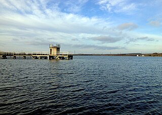
Edgbaston Reservoir, originally known as Rotton Park Reservoir and referred to in some early maps as Rock Pool Reservoir, is a canal feeder reservoir in Birmingham, England., maintained by the Canal & River Trust. It is situated close to Birmingham City Centre and is a Site of Importance for Nature Conservation.

Longbridge is an area of south-west Birmingham, England. For local government purposes it is a ward within the district of Northfield.

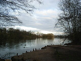
Lifford Reservoir in the Kings Norton district of Birmingham, England was built by the Worcester & Birmingham Canal company in 1815 to compensate Lifford Mill for water lost to the canal. It is located at the junction of the Stratford-upon-Avon Canal and the Worcester and Birmingham Canal and is on the River Rea Cycle Route. Angling is permitted subject to a charge outside the spring close season. Fish in the reservoir include tench, carp, pike, eels, perch, roach and bream.

Kingfisher Country Park is a country park in Britain. It is situated in East Birmingham, West Midlands. Initially designated as Project Kingfisher by Birmingham City Council, the park was formally declared a country park in July 2004. The country park is located along an 11 km stretch of the River Cole from Small Heath (Birmingham) to Chelmsley Wood (Solihull) at the M6 motorway. It is a Local Nature Reserve.
Plants Brook is a stream in Erdington and Sutton Coldfield, Birmingham, England. It is a tributary of the River Tame, whose waters ultimately flow, via the Humber Estuary, into the North Sea.

Kings Norton Stop Lock is a Grade II* listed building at Kings Norton Junction on the Stratford-upon-Avon Canal near its junction with the Worcester and Birmingham Canal. It is the only guillotine-gated stop-lock on a canal.

Siston Brook rises in two separate streams which issue from a ridge just north of the village of Siston, South Gloucestershire, England. The brook is approximately 6 miles (9.7 km) long and is a tributary of the Bristol Avon. Much of its course is through the eastern suburbs of Bristol, although it remains outside the city boundaries. Tributaries include the Warmley Brook and an unnamed tributary from Bridgeyate.
Plantsbrook Local Nature Reserve is a nature reserve on the Plants Brook in The Royal Town of Sutton Coldfield, near Birmingham, England, consisting of open water, wetland, woodland and meadow. It is located on Eachelhurst Road, on the border of the Pype Hayes and Walmley districts. It was designated a Local Nature Reserve in 1991.

Birmingham has 571 parks totalling over 3,500 hectares (14 sq mi) of public open space, more than any other equivalent sized European city. The centrepieces of Birmingham's park system are the five Premier Parks. Ten parks have received the prestigious Green Flag Award. The city also has five local nature reserves, one national nature reserve and a number of Wildlife Trust nature reserves.


