Yervandashat, Armenia

Last updated

Coordinates: 40°06′53″N43°40′15″E / 40.11472°N 43.67083°E / 40.11472; 43.67083

Geographic coordinate system Coordinate system

A geographic coordinate system is a coordinate system that enables every location on Earth to be specified by a set of numbers, letters or symbols. The coordinates are often chosen such that one of the numbers represents a vertical position and two or three of the numbers represent a horizontal position; alternatively, a geographic position may be expressed in a combined three-dimensional Cartesian vector. A common choice of coordinates is latitude, longitude and elevation. To specify a location on a plane requires a map projection.

Contents

Yervandashat
Երվանդաշատ

Yervandashat.JPG

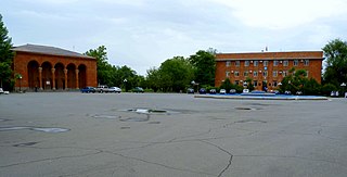
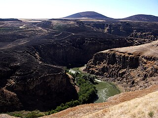
Overlooking village of Yervandashat.
Armenia adm location map.svg
Red pog.svg
Yervandashat
Երվանդաշատ
Coordinates: 40°06′53″N43°40′15″E / 40.11472°N 43.67083°E / 40.11472; 43.67083
Country Armenia
Marz (Province) Armavir
Founded 3rd century BCE
Population (2001)
  Total 695
Time zone   (UTC+4)

Yervandashat (Armenian : Երվանդաշատ) is a village in the Armavir Province of Armenia. The village has a ruined basilica dated to the 4th or 5th century and the Saint Shushanik church of the 10th to 17th century. Along the main highway leading to and from the area are khachkar monuments. It is named after the nearby Armenian historic city of Yervandashat

Armenian language Indo-European language

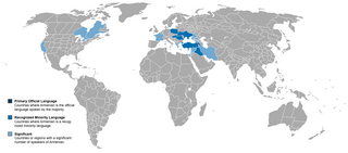
The Armenian language is an Indo-European language spoken primarily by Armenians. It is the official language of Armenia. Historically being spoken throughout the Armenian Highlands, today, Armenian is widely spoken throughout the Armenian diaspora. Armenian is written in its own writing system, the Armenian alphabet, introduced in 405 AD by Mesrop Mashtots.

Village Small clustered human settlement smaller than a town

A village is a clustered human settlement or community, larger than a hamlet but smaller than a town, with a population ranging from a few hundred to a few thousand. Though villages are often located in rural areas, the term urban village is also applied to certain urban neighborhoods. Villages are normally permanent, with fixed dwellings; however, transient villages can occur. Further, the dwellings of a village are fairly close to one another, not scattered broadly over the landscape, as a dispersed settlement.

Armavir Province Province in Armenia

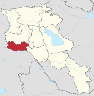
Armavir, is a province (marz) in the western part of Armenia. Located in the Ararat plain dominated by Mount Ararat from the south and Mount Aragats from the north, the province's capital is the town of Armavir while the largest city is Vagharshapat (Etchmiadzin). The province shares a 72 km (45 mi)-long border with Turkey to the south and west.

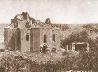
1 km east of the modern village -within the Turkish borders- are the ruins of ancient Yervandashat, a city founded by King Orontes IV (the last of the Orontid Dynasty), in 210 BC. The ancient town sits upon an escarpment overlooking the junction of the Arax River and Akhurian River. According to Movses Khorenatsi, Orontes founded Yervandashat to replace Armavir as his capital after Armavir had been left dry by a shift of the Arax River.

Orontes IV was the son of King Arsames and is recorded as ruling Armenia from inscriptions found at the historic capital of the Orontid dynasty, Armavir. He was the founder of the city of Yervandashat. In his reign the religious site of Bagaran was founded. Large bronze statues in the Hellenistic style of the gods, Zeus (Aramazd), Artemis (Anahit) and Herakles (Vahagn) were brought there and set up in temples dedicated to them. He is also said to have founded a shrine at Armavir dedicated to Apollo (Mithra), a golden statue of four horses pulling a chariot with Apollo as god of the Sun. This was later destroyed by the Sassanid Persian army in the 4th century AD.

Akhurian River

The Akhurian, Akhuriyan, Akhuryan or Akhouryan is a river in the South Caucasus. It originates in Armenia and flows from Lake Arpi, along the closed border with Turkey, forming part of the geographic border between the two states, until it flows into the Aras River as a left tributary near Bagaran. The Akhurian drains an area of about 9,500 square kilometres (3,700 sq mi) and has total length of 186 kilometres (116 mi).

Ancient Yervandashat was destroyed by the army of the Persian King Shapur II in the 360s.

Shapur II Shah of Persia

Shapur II, also known as Shapur II the Great, was the tenth Shahanshah of the Sasanian Empire. The longest-reigning monarch in Iranian history, he reigned for his entire 70-year life from 309 to 379. He was the son of Hormizd II.

However, The archaeological site has not been subject of major research, but preliminarily, the fortifications and some remains of palaces have been uncovered.

See also

Related Research Articles

Kingdom of Armenia (antiquity) ancient state of Armenia

The Kingdom of Armenia, also the Kingdom of Greater Armenia, or simply Greater Armenia, sometimes referred to as the Armenian Empire, was a monarchy in the Ancient Near East which existed from 321 BC to 428 AD. Its history is divided into successive reigns by three royal dynasties: Orontid, Artaxiad and Arsacid (52–428).

Armavir, Armenia Place in Armavir, Armenia

Armavir, is a town and urban municipal community located in the west of Armenia serving as the administrative centre of Armavir Province. It was founded in 1931 by the government of the Armenian Soviet Socialist Republic. As of the 2011 census, the population of the town is 29,319, declined from 46,900 reported at the 1989 census. Currently, the town has an approximate population of 28,900 as per the 2016 official estimate.

The Orontid dynasty, also known by their native name Eruandid or Yervanduni, was a hereditary Armenian dynasty and the rulers of the successor state to the Iron Age kingdom of Urartu (Ararat). The Orontids established their supremacy over Armenia around the time of the Scythian and Median invasion in the 6th century BC.

Amasia, Armavir Place in Armavir, Armenia

Amasia is a village in the Armavir Province of Armenia.

Amberd, Armavir Place in Armavir, Armenia

Amberd ; known as Franganots until 1978, is a village in the Armavir Province of Armenia. The village is home to the historic church of Thomas the Apostle, dating back to the 12th century.

Araks, Armavir Place in Armavir, Armenia

Araks, is a village in the western part of the Armavir Province of Armenia. It was founded as a state farm in 1940. The Battle of Sardarapat of 1918, took place near the village of Araks. In 1968, the Sardarapat Battle Memorial was erected on the site of the battle.

Armavir (village) Place in Armavir, Armenia

Armavir is a village in the Armavir Province of Armenia. Cuneiform inscriptions of Urartian King Sarduri II were found at Armavir.

Baghramyan, Armavir Place in Armavir, Armenia

Baghramyan, Bagramyan or Bagramian, is a village in the Armavir Province of Armenia. It is named after the Soviet Armenian military commander and Marshal of the Soviet Union Hovhannes Baghramyan.

Lernagog Place in Armavir, Armenia

Lernagog, is a village in the Armavir Province of Armenia. Formerly a sovkhoz, The village is sponsored by COAF Children of Armenia Fund and is one of the cleanest villages in Armenia. It has a very good school with the first creativity lab in Armenia.

Margara Place in Armavir, Armenia

Margara is a town in the Armavir Province of Armenia. Margara is the closest border crossing to Turkey from Yerevan. Margara has a road bridge across the Arax River to Turkey. The Border Guard Service of Russia patrols the closed border between Armenia and Turkey.

Nor Armavir Place in Armavir Province, Armenia

Nor Armavir is a village in the Armavir Province of Armenia. The village was founded in 1923 by Armenian refugees from Turkey, who named the village after the ancient city of Armavir, which has its ruins nearby. However, The village is known first and foremost for the Battle of Sardarabad during the Caucasus Campaign, as the battle occurred on the modern site of the town in 1918.

Aygevan Place in Armavir, Armenia

Aygevan ; formerly Sovkhoz Nomer Shest –, later Imeni Stalina, later Dzerzhinski and Imeni Dzerzhinskogo, is a village in the Armavir Province of Armenia. It was founded as a state farm in 1946 and named after Felix Dzerzhinski, head of the Soviet secret police.

Shenik, Armavir Place in Armavir, Armenia

Shenik, is a village in the Armavir Province of Armenia. It was founded in 1969 in the southwestern part of Armavir Province, at an area was once closed to foreigners.

Sardars Fortress

Sardari Berd sits on the right before the cemetery in the village of Sardarapat in the Armavir Province of Armenia.

Armavir (ancient city) historical capital

Armavir was a large commercial city and the capital of ancient Armenia during the reign of the Orontid Dynasty. It is located 1 km west of the 17th-century village of Armavir.

Yervandashat (ancient city)

Yervandashat, was an Armenian city and one of the 13 historic capitals of Armenia, serving as a capital city between 210 and 176 BC during the Orontid rule over Armenia and the beginning of their successors; the Artaxiad dynasty.

Bagaran, Armavir Place in Armavir, Armenia

Bagaran is a village in the Armavir Province of Armenia. Its name is derived from the nearby ancient Armenian city of Bagaran which was a large city and fortress that straddled both banks of the Akhurian River, and served as a former capital of medieval Armenia. A small Kurdish-populated village called Kılıttaşı now partially lies on the Turkish side of the closed border.

Bagaran (ancient city) capital

Bagaran , was a city in Ancient Armenia founded during the reign of the Orontid Dynasty. It is one of the Historical capitals of ancient Armenia.

References

The GEOnet Names Server (GNS) provides access to the National Geospatial-Intelligence Agency's (NGA) and the U.S. Board on Geographic Names's (BGN) database of geographic feature names and locations for locations outside the United States. The database is the official repository of foreign place-name decisions approved by the US BGN. Approximately 20,000 of the database's features are updated monthly. The database never removes an entry, "except in cases of obvious duplication".

National Statistical Service of Republic of Armenia is the national statistical agency of Armenia.