Conflicting claims
Virginia's claim was for a wedge from their coastal area all the way to the Pacific Ocean. Pennsylvania's was for five degrees of longitude west of the Delaware River. By the 1770s it was obvious that the two claims overlapped, in the area that in 1773 had been designated by Pennsylvania as Westmoreland County, because settlers were moving into the area from both directions. Both claims included the entire southwestern corner of what is now Pennsylvania, west of the Laurel Ridge in the Allegheny Mountains and south of the Kiskiminetas, Allegheny, and Ohio rivers. The major prize location was the confluence of the Allegheny and Monongahela rivers, forming the Ohio River, at the location of Fort Pitt, now the city of Pittsburgh. The disputes over which colony had authority over the area led to overlapping land grants to settlers and battles between Virginians and Pennsylvanians in the period 1774–1775. In 1774, a Virginian militia group even attacked and captured the Westmoreland County seat at Hannastown and arrested three Westmoreland County justices who refused to acknowledge the jurisdiction of Virginia.
Similar conflicts between Maryland and Pennsylvania had been resolved earlier, by 1767, through the work of two men chosen by Cecil Calvert, brother of Charles Calvert, 5th Baron Baltimore, proprietor of Maryland, and Thomas Penn and his brother Richard, sons of William Penn and proprietors of Pennsylvania. Astronomer Charles Mason, an acquaintance of Benjamin Franklin, and surveyor Jeremiah Dixon came from England to do this work. The line they located has since been known as the Mason–Dixon line or Mason and Dixon's Line. However, their authority extended west only as far as western Maryland, and did not resolve border conflicts between Virginia and Pennsylvania.
Creation of Yohogania County
In 1776, shortly after the American Revolutionary War began, the Virginia General Assembly formed three new counties from the District of West Augusta, an area of Augusta County, Virginia, which encompassed much of what is now northern West Virginia and southwestern Pennsylvania. These were Monongalia County, Ohio County, and Yohogania County. All three included, or at least claimed, land in what is now Pennsylvania as well as in Virginia, now West Virginia. The new counties were named after rivers in the region, the Ohio, the Monongahela, and the Youghiogheny, the latter two being Latinized to create the county names. The county seat of Yohogania County was near the Monongahela River, within the present borough of Jefferson Hills across from Elizabeth.
On December 27, 1779, a resolution by the Second Continental Congress recommended to the two now-states of Virginia and Pennsylvania that, rather than continue to quarrel with each other as well as fighting the British, they should reach an agreement on the border situation. This was done in theory by an agreement reached by commissioners from both states in Baltimore in 1779, and ratified by the legislatures of both states in 1780, "to extend the line commonly called Mason and Dixon's line five degrees of longitude from Delaware River ... and from the western termination thereof to run and mark a meridian line to the Ohio River," which was the northern boundary of Virginia's claim. That would be the boundary between the two states.
The conflict apparently being over, Pennsylvania carved Washington and Fayette counties out of Westmoreland in 1781 and 1783, respectively. These counties contained land claimed by Yohogania and Ohio or (in Fayette's case) Monongalia counties. But confusion over jurisdictions continued.
Boundary survey
On November 4, 1782, Colonel Joseph Neville, representing Virginia, and Alexander McClean of Pennsylvania marked a temporary line. A final, permanent survey was performed by Neville and Andrew Ellicott, a Marylander representing Virginia. The corner was marked late in 1784—the report to the commissioners of both states being dated November 18, 1784—and on August 23, 1785, the boundary as far north as the Ohio River (near present-day East Liverpool, Ohio) was completed. In 1786 the line was continued to Lake Erie, marking the boundary between Pennsylvania and the portion of the Northwest Territory that in 1803 became the state of Ohio. (Virginia's claim to the Northwest Territory had been ceded to Congress in 1784.)
The survey determined that parts of Ohio and Monongalia counties and nearly all of Yohogania County were within the Pennsylvania boundaries. The areas of Yohogania County ceded to Pennsylvania included all of present-day Westmoreland County and parts of the present counties of Allegheny, Beaver, Washington, and Fayette. The portion of Yohogania remaining in (West) Virginia's Northern Panhandle—itself a creation of the border settlement—was deemed too small at the time to form a county, and was annexed to Ohio County. (Similarly, part of Ohio County's claim is now in Washington and Greene Counties in Pennsylvania, and part of what had been considered Monongalia County are in Washington, Greene, and Fayette counties, Pennsylvania.) In 1797, Virginia created Brooke County from the northern portion of Ohio County. Later, as the population of the region continued to grow, Hancock County was created from the northern portion of Brooke County in 1848, with the county line being drawn through the middle of the village of Hollidays Cove, now Weirton.
Reorganization of local government after resolution of boundary dispute
Allegheny County was formed in 1788 from Westmoreland and Washington counties. Most of the present territory of Allegheny County, including most of Pittsburgh (with the notable exception of what is now the northside (Pittsburgh), formerly its own municipality Allegheny City), was once claimed by Yohogania. Beaver County was created in 1800 from parts of Allegheny and Washington. The southern part, known locally as "South Side Beaver" because it is south of the Ohio River, was once claimed by Yohogania. (Greene County, formed in 1796 from Washington, does not include any territory once claimed by Yohogania but was once claimed by Ohio and Monongalia counties.)
The part of Yohogania that remained in Virginia was from Cross Creek north. This creek is just south of the present-day town of Follansbee, West Virginia, entering the Ohio River across from Mingo Junction, Ohio. In 1791, this remnant area was made part of the newly created Brooke County, Virginia, though the southern part of Brooke, including the county seat, Wellsburg, had been part of Ohio County. In 1848, the northern half of Brooke—roughly two-thirds of the Yohogania remnant—became Hancock County, Virginia. On June 20, 1863, both Brooke and Hancock, as well as Ohio and Monongalia (and the counties since formed from Ohio and Monongalia) became part of the new state of West Virginia.

Allegheny County is a county in Pennsylvania, United States. It is located in Southwestern Pennsylvania. As of the 2020 census, the population was 1,250,578, making it the state's second-most populous county, after Philadelphia County. Its county seat and most populous city is Pittsburgh, Pennsylvania's second most populous city. Allegheny County is part of the Pittsburgh, PA metropolitan statistical area and the Pittsburgh media market.

Monongalia County, known locally as Mon County, is located in the U.S. state of West Virginia. As of the 2020 census, the population was 105,822, making it West Virginia's third-most populous county. Its county seat is at Morgantown. The county was founded in 1776. Monongalia County is included in the Morgantown, WV Metropolitan Statistical Area, and is the largest county in North-Central West Virginia. It is part of the Pittsburgh media market.
Springhill Township is a township in Fayette County, Pennsylvania, United States. The population was 2,723 at the 2020 census. The Albert Gallatin Area School District serves the region.

Washington Township is a township in Fayette County, Pennsylvania, United States. The population was 3,889 at the 2020 census, down from 3,902 at the 2010 census.

Westsylvania was a proposed state of the United States located in what is now West Virginia, southwestern Pennsylvania, and small parts of Kentucky, Maryland, and Virginia. First proposed early in the American Revolution, Westsylvania would have been the fourteenth state in the newly formed United States, had it been recognized.
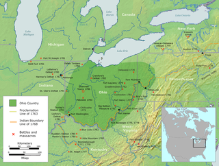
The Ohio Country, was a name used before 1787 for a region of North America west of the Appalachian Mountains north of the upper Ohio and Allegheny rivers, and extending to Lake Erie. The area encompassed present-day northwestern West Virginia, Western Pennsylvania, most of Ohio, and a wedge of southeastern Indiana.

The Youghiogheny River, or the Yough for short, is a 134-mile-long (216 km) tributary of the Monongahela River in the U.S. states of West Virginia, Maryland, and Pennsylvania. It drains an area on the west side of the Allegheny Mountains northward into Pennsylvania, providing a small watershed in extreme western Maryland into the tributaries of the Mississippi River. Youghiogheny is a Lenape word meaning "a stream flowing in a contrary direction".

The Ohio Company, formally known as the Ohio Company of Virginia, was a land speculation company organized for the settlement by Virginians of the Ohio Country and to trade with the Native Americans. The company had a land grant from Britain and a treaty with Indians, but France also claimed the area, and the conflict helped provoke the outbreak of the French and Indian War.

The Cheat River is a 78.3-mile-long (126.0 km) tributary of the Monongahela River in eastern West Virginia and southwestern Pennsylvania in the United States. Via the Ohio River, the Cheat and Monongahela are part of the Mississippi River watershed. Owing to the ruggedness of the surrounding Allegheny Mountains, the Cheat remains largely remote with few settlements or developments along its banks. Its headwaters are in the Cheat-Potomac Ranger District of the Monongahela National Forest.

The District of West Augusta was a short-lived (1774–76) historical region of Colonial Virginia that encompassed much of what is now northern West Virginia and southwestern Pennsylvania.

Greater Pittsburgh is the metropolitan area surrounding the city of Pittsburgh in Western Pennsylvania, United States. The region encompasses Pittsburgh's urban core county and economic hub, Allegheny, and seven adjacent Pennsylvania counties: Armstrong, Beaver, Butler, Fayette, Lawrence, Washington, and Westmoreland in Western Pennsylvania, which constitutes the Pittsburgh, PA Metropolitan Statistical Area MSA as defined by the U.S. Census Bureau.

Transportation in Pittsburgh, Pennsylvania is different than in many other major American cities. A large metropolitan area that is surrounded by rivers and hills, Pittsburgh has an infrastructure system that has been built out over the years to include roads, tunnels, bridges, railroads, inclines, bike paths, and stairways; however, the hills and rivers still form many barriers to transportation within the city.
John Neville was an American military officer, land speculator, and local official who served in the French and Indian War, Lord Dunmore's War and the American Revolutionary War. As an early federal tax collector he became a central figure in the Whiskey Rebellion.
Pennsylvania Route 51 is a major state highway that is located in Western Pennsylvania in the United States. It runs for 89 miles (143 km) from Uniontown to the Ohio state line near Darlington, where it connects with Ohio State Route 14.
Pennsylvania Route 906 is a 10.6-mile-long (17.1 km) state highway located in Fayette, Westmoreland, and Allegheny counties in Pennsylvania. The southern terminus is at PA 201 in Washington Township. The northern terminus is at PA 136 in Forward Township.
William Haymond was a military officer and surveyor. Haymond served in the French and Indian War and the Revolutionary War. Prior to the Revolution, he served in George Washington's Virginia Regiment. In 1781, during the Revolution, Haymond was commissioned to major by Benjamin Harrison V. After the Revolution, he served as an official surveyor in what is now West Virginia.

Brownsville Road is a road between Pittsburgh, at Eighteenth Street and South Avenue in Allegheny County, Pennsylvania eastwards through Mount Oliver and generally highlands situated along or near the hilltops often overlooking the Monongahela River. It has had several names over its history, and was also known at the Red Stone Road and the period it was a Plank Road managed as a toll road, the Brownsville Plank Road, or the Brownsville Turnpike, or locally, as the area grew into a city, Southern Avenue.

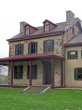
Thomas Gaddis (1742–1834) was a militia officer in the American Revolutionary War. He was born December 28, 1742, in Winchester, Frederick County, Virginia and married Hannah Rice in 1764; the same year he built Fort Gaddis, a refuge from the Indians, located on the Catawba Trail. In fact, Pennsylvania and Virginia had conflicting claims in the area Gaddis settled. Though he maintained his loyalty to Virginia, Gaddis also protected his investment by recording his patent with Pennsylvania authorities. By 1773, both states created new geo-political boundaries in recognition of increased white settlement. Pennsylvania formed Westmoreland County out of the larger Bedford County, and Virginia established the District of West Augusta. In 1776, West Augusta was further divided into three counties: Ohio, Yohogania, and Monongalia, where Gaddis and his family resided.
Pitt Township was one of the original townships created with the formation of Allegheny County, Pennsylvania in 1788. It repeatedly diminished in size until dissolving into the city of Pittsburgh in 1868.
