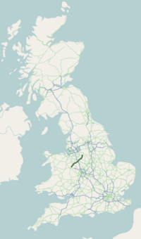
Staffordshire is a landlocked ceremonial county in the West Midlands of England. It borders Cheshire to the northwest, Derbyshire to the east, Warwickshire to the southeast, the West Midlands county and Worcestershire to the south, as well as Shropshire to the west. The largest settlement is the city of Stoke-on-Trent; the county town is Stafford.

The A41 is a trunk road between London and Birkenhead, England. Now in parts replaced by motorways, it passes through or near Watford, Kings Langley, Hemel Hempstead, Aylesbury, Bicester, Solihull, Birmingham, West Bromwich, Wolverhampton, Newport, Whitchurch, Chester and Ellesmere Port.

The A5, the London-Holyhead trunk road, is a major road in England and Wales. It runs for about 243 miles (391 km) from London to the Irish Sea at the ferry port of Holyhead. In many parts the route follows that of the Roman Iter II route which later took the Anglo-Saxon name Watling Street.

The A6 is one of the main north–south roads in England. It runs from Luton in Bedfordshire to Carlisle in Cumbria, although it formerly started at a junction with the A1 at Barnet. It is the fourth longest numbered road in Britain; only the A1, A38 and A30 are longer.

The A61 is a major trunk road in England connecting Derby and Thirsk in North Yorkshire by way of Alfreton, Clay Cross, Chesterfield, Sheffield, Barnsley, Wakefield, Leeds, Harrogate and Ripon. The road is closely paralleled by the M1 motorway between Derby and Leeds.

Market Drayton is a market town and electoral ward in north Shropshire, England, close to the Cheshire and Staffordshire borders. It is on the River Tern.

The A48 is a trunk road in Great Britain running from the A40 at Highnam, 3 miles (4.8 km) west of Gloucester, England, to the A40 at Carmarthen, Wales. Before the Severn Bridge opened on 8 September 1966, it was a major route between England and South Wales. For most of its route, it runs almost parallel to the M4 motorway. During times of high winds at the Severn Bridge, the A48 is used as part of the diversion route and is still marked as a Holiday Route.

The A49 is an A road in western England, which traverses the Welsh Marches region. It runs north from Ross-on-Wye in Herefordshire via Hereford, Leominster, Ludlow, Shrewsbury and Whitchurch, then continues through central Cheshire to Warrington and Wigan before terminating at its junction with the A6 road just south of Bamber Bridge, near the junction of the M6, M65 and M61 motorways.

The A52 is a major road in the East Midlands, England. It runs east from a junction with the A53 at Newcastle-under-Lyme near Stoke-on-Trent via Ashbourne, Derby, Stapleford, Nottingham, West Bridgford, Bingham, Grantham, Boston and Skegness to the east Lincolnshire coast at Mablethorpe. It is approximately 147 miles (237 km) long.

BBC Radio Stoke is the BBC's local radio station serving Staffordshire and South Cheshire.

The A500 is a major primary A road in Staffordshire and Cheshire, England. It is dual carriageway for most of its length and connects Nantwich, junctions 16 and 15 of the M6 motorway with the city of Stoke-on-Trent. It is 19 miles (31 km) long.

Tern Hill, also known as Ternhill, is a village in Shropshire, England, notable as the location of the former RAF Tern Hill station, which is now operated by the British Army as Clive Barracks. The settlement is named after the River Tern which begins just south of the settlement. The population for the village as taken in the 2011 census can be found under Moreton Say.

The A43 is a primary route in the English Midlands and northern South East England, that runs from the M40 motorway near Ardley in Oxfordshire to Stamford in Lincolnshire. Through Northamptonshire it bypasses the towns of Northampton, Kettering and Corby which are the three principal destinations on the A43 route. The A43 also links to the M1 motorway.

The A453 road was formerly the main trunk road connecting the English cities of Nottingham and Birmingham. However, the middle section of this mainly single-carriageway road has largely been downgraded to B roads or unclassified roads following the construction of the parallel M42-A42 link around 1990. The M42 was originally meant to pass further north than it does, and to join the M1 at Sandiacre in Derbyshire. The M42/A42 does not enter Derbyshire, but instead joins the M1 closer to the A453 junction at Kegworth. The A42 shadows the former A453 from Appleby Magna to Castle Donington. The road historically connected the East Midlands with the West Midlands.

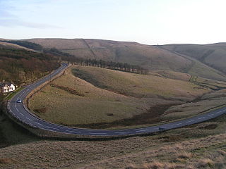
The A54 road is a road in England linking Chester in Cheshire with Buxton in Derbyshire. Its route through both urban and steep rural areas presents a challenge to Cheshire County Council in maintaining the safety of the road. Many years ago it was the main east–west route in Cheshire. The importance of the A54 through Middlewich and Winsford decreased in the 1970s and 1980s with the building of the M56 motorway and dualling of the A556 at Northwich. The section through Winsford carries approximately 30,000 vehicles per day.

Shawbury United Football Club are a football club originally from Shawbury, Shropshire, but currently based in Shrewsbury, Shropshire, England. They were established in 1992. They are members of the Midland League Division One, having been relegated from the Midland Football League Premier Division at the end of the 2017-18 season.

The A1079 is a major road in Northern England. It links the cities of York and Kingston upon Hull, both in Yorkshire. The road is noted for its past safety issues, and regularly features in the Road Safety Foundations reports on Britain's most dangerous roads. Campaigners have been calling for the entire route to be made into a dual carriageway.
The A5004 is an A road in Derbyshire, England running north from Buxton to Whaley Bridge. A large section of the road is called Long Hill. It was formerly part of the A6. It runs through a scenic area of the Peak District National Park. In 2010 it was named as the seventh most dangerous road in Britain.

The M54 is a 23-mile (37 km) east-west motorway in the counties of Shropshire and Staffordshire, England. It is also referred to as the Telford motorway, after the road's primary westbound destination, the town of Telford. It cost £65 million to construct, and is two-lane dual carriageway for the majority of its length, with sections of three-lane.
Sneyd Green is an area in the city of Stoke-on-Trent, Staffordshire, England, in the north-east of the city, 1.5 miles (2.4 km) from Hanley. Sneyd Green borders Smallthorne in the north, Milton in the east, Birches Head in the south, and Cobridge in the west.