Arden, Warwickshire

Last updated

Arden
Map Showing the Territory of the Forest of Arden.jpg
Map showing the traditional territory of the Forest of Arden by reference to the Roman roads that formed its boundary
Geography
LocationWest Midlands, Warwickshire, Worcestershire, Shropshire.

The Forest of Arden is a former forest and culturally defined area located in the English West Midlands, [1] that in antiquity and into the Early Modern Period included much of Warwickshire, and parts of Shropshire, [2] [3] [4] Staffordshire, the West Midlands, and Worcestershire. [5] [6] [7] It is associated with William Shakespeare as a territory of his youth, and the setting of some of his drama.

Contents

The Forest of Arden area was first mapped according to the Roman roads which conceptually bounded it: in the West by the Icknield Street, in the South by the Salt Road (the modern Alcester to Stratford Road), in the East by the Fosse Way, and in the North by the Watling Street. [8] [9] [10] [11] The Gough Map shows this traditional extent of the forest. [1]

More recently the shorter term 'Arden' has been used to describe a smaller area primarily concentrated in the historic county of Warwickshire and parts of the modern West Midlands metropolitan county.

History

Early history

Birmingham illustrated on the fourteenth century Gough Map, shown within the Forest of Arden on the road between Lichfield (left) and Droitwich (right) Gough Map Birmingham.jpg
Birmingham illustrated on the fourteenth century Gough Map, shown within the Forest of Arden on the road between Lichfield (left) and Droitwich (right)

Believed to be derived from a Brythonic word ardu- "high" (cf. Welsh : ardd), by extension "highland", the area was formerly thickly forested and known as the Forest of Arden. Located near the geographical centre of England, the Forest of Arden, through which no Roman roads were built, was bounded by the Roman roads Icknield Street, Watling Street, Fosse Way, and a prehistoric salt track leading from Droitwich. [12] It included the north-western half of the traditional county of Warwick, stretching from Stratford-upon-Avon in the south to Tamworth in the north, and as well as areas that are now the large settlements of Birmingham, Coventry and Shrewsbury, in addition to areas that are still largely rural with numerous areas of woodland. A significant settlement in the forest was the town Henley-in-Arden (in a valley of the River Alne, approximately 15 miles southeast of Birmingham), the site of an Iron Age hillfort.

Wide lands in this district were held in the time of Edward the Confessor by Alwin, whose son Thurkill of "of Arden," founded the family of this name. [7] The Domesday book reveals that in 1086 the Forest of Arden was comparatively lightly settled, and poor in terms of agricultural wealth. [13]

An ancient mark stone known as Coughton Cross [14] is still present at the southwestern corner of the forest, at the junction of Icknield Street (now A435) and the salt track, now the southern end of the frontage of Coughton Court, and is owned by the National Trust. According to local tradition, travellers prayed here for safe passage through the forest.

Arms of the Arden family Arden of Park Hall arms.svg
Arms of the Arden family

Thorkell of Arden, a descendant of the ruling family of Mercia, was one of the few major English landowners who retained extensive properties after the Norman conquest. His progeny, the Arden family, remained prominent in the area for centuries, by the 14th century, under Sir Henry de Arden, the most prominent Ardens had their primary estate at Park Hall, Castle Bromwich, Solihull. [15] Connection to this ancient family was important in the identity work of the Dudley family in the sixteenth century. [16]

Mary Arden, mother of William Shakespeare, was a member of this prominent West Midlands family, [17] who had also had a prominent centre of power in Stockport in the 1500s. [18]

From around 1162, until the suppression of their order in 1312, the Knights Templar owned a preceptory at Temple Balsall in the middle of the Forest of Arden. The property then passed to the Knights Hospitaller, who held it until the Reformation during the 16th century.

During the medieval era it is believed the forest began to become enclosed and deforested.

Early modern period

Robert Catesby, leader of the Gunpowder Plot of 1605, was a native of Lapworth, a village in Arden. It is believed that many local families across the Arden area had resisted the Reformation and retained Catholic sympathies, possibly including the family of Shakespeare, whose paternal ancestors were from the Balsall area.

Many of the key engagements of English Civil War of 1642 – 1651 were fought in the Arden area, such as the Battle of Camp Hill.

Culture and cultural references

William Shakespeare was familiar with The Forest of Arden and set drama there, most notably As You Like It. Shakespeare Droeshout 1623.jpg
William Shakespeare was familiar with The Forest of Arden and set drama there, most notably As You Like It.

Shakespeare

Marie Davey as Rosalind in As You Like It 2017 As You Like it 2017 Rosalind.jpg
Marie Davey as Rosalind in As You Like It 2017

Shakespeare's play As You Like It is set in the Forest of Arden, but it is an imaginary version incorporating elements from the Ardennes forest in Thomas Lodge's prose romance Rosalynde; Or, Euphues' Golden Legacy and the real forest (both as it was when the play was written, i.e. subjected to deforestation and enclosure, and the romanticized version of his youth). [19] Lodge was familiar with the English Forest of Arden via the ownership and occupation by the family of the manor Soulton by his father, Sir Thomas Lodge.

This manor is located on the boundaries of the English Forest of Arden in a territory in which the Tudor Statesman Sir Rowland Hill was active, furnishing a possible inspiration for Shakespeare's character Old Sir Rowland. [20] [21] [22] [23]

Shakespeare's Arden seems to have promulgated a vision of the forest that fits in with the English nostalgic autostereotype of Merry England, and inspired subsequent artists such as Pre-Raphaelite John Collier.

Myths and legends

The status of Coventry as an isolated settlement surrounded by the thick Forest of Arden has been cited by some historians as a cause for the prospering of a cult of the pagan goddess Cofa after the rest of the country had been Christianised.

It is believed that in the 12th century, this localised cult had transferred its veneration from the goddess Cofa to Lady Godiva, an Anglo Saxon Countess of the area. The warping of the myths with the real historical figure of Godiva, could explain many of the legends associated with her. [24]

According to the legend, the hero Sir Guy of Warwick set up his hermitage at Guy's Cliffe in the Forest of Arden, overlooking the River Avon.

In other fiction

John Collier - In the Forest of Arden John Collier - In the Forest of Arden.jpg
John Collier - In the Forest of Arden

Moseley Bog is a remnant of the Forest of Arden, now a local nature reserve that inspired the Old Forest in J. R. R. Tolkien's The Lord of the Rings books. [25] [26]

Court offices

In 1758 the Earl of Aylesford and five others founded (or possibly refounded) the Woodmen of Arden. This is an exclusive archery club that takes its offices from the medieval Royal Forest court positions, such as Verderer and Warden.

The organisation claims to be a successor to an older organisation of woodmen, however there is scant evidence that forest law ever applied in the Forest of Arden.

Forest law

Remains of Wayside Cross Marking South Western Corner of The Forest of Arden Remains of Wayside Cross Marking South Western Corner of The Forest of Arden 01.JPG
Remains of Wayside Cross Marking South Western Corner of The Forest of Arden

Unlike other forests of the era it does not appear that the Forest of Arden was ever subject to forest law. It is unclear why this is, however it is possibly because wide-scale settlement of the area did not occur until comparatively late, and thus the forest still represented something of a frontier. [13]

This may have been due to the density and size of the forest – which overlies a large area of clay resulting in natural vegetation of dense broad-leaved woodland like oak and lime – as well as the dangers within such as bears and wolves, which did not become extinct in Great Britain until the sixth and seventeenth centuries respectively. [27] No Roman road penetrated the forest; Icknield Street, Watling Street, and Fosse Way all went around it instead, and a salt track bounded the south side.

The Domesday book indicates that the area was still little settled by 1086, with a handful of former Iron Age hill forts, Roman forts, and Anglo-Saxon settlements at places like Henley-in-Arden, Coleshill and Ulverlei. A medieval era wayside cross known as the Coughton Cross sits at the southern boundary of the forest, and was allegedly a site where travelers would pray for safe passage through the forest prior to entering.

Forest Hall of the Woodmen of Arden Gates and former workshop, Forest Hall, Meriden (geograph 2590148).jpg
Forest Hall of the Woodmen of Arden

The first major wave of settlement of assarts occurred from the eleventh century to the fourteenth century, as a result of "peasant land hunger" from settlements south of Arden and "seignorial encouragement" and lords desiring to expand their holdings and political power. Even so, settlers had to be enticed to colonise the area. In the planted borough of Solihull the Lord of the Manor offered free burgage tenure in which residents were free, rent-paying burgesses, rather than villeins owing service to the Lord of the Manor. In Tanworth in Arden the Earl of Warwick pursued a policy as overlord that unusually saw over 60 per cent of the income from this manor derived from free rents. [13]

Royal forests subject to forest law were established on wooded land adjoining the Forest of Arden, at Sutton Park in the Anglo-Saxon era, and Feckenham Forest in the early Norman era, both much smaller and more manageable than the vast untamed land of Arden.

Despite the lack of evidence that the Forest of Arden was ever under forest law, the Woodmen of Arden, founded (or refounded) in 1758, claim to be a revival of a body who traditionally exercised the role of crown forestry officials in the area.

Geography

The area is punctuated by a large number of settlements – such as Bearley, Shirley and Henley – ending with 'ley', meaning 'a clearing'. There are also a large number of areas with references to woodland, such as Kingswood, Nuthurst, Packwood, Hollywood, Earlswood, Four Oaks, and so on. [28]

1000 year old oak tree in the grounds of Stoneleigh Abbey 1000 year old Tree.jpg
1000 year old oak tree in the grounds of Stoneleigh Abbey

It is not known exactly when deforestation began, but even in the 16th century it was understood that the forest of Arden had been diminished from what it had been due to enclosure and later logging, due amongst other things to the demands of the navy for wood. [29]

The forest itself is today mostly reduced to individual oaks, hedgerows and occasional pockets of ancient woodland, such as the former Royal Forest of Sutton Park and Rough Wood. Ecologist Steven Falk, undertaking research with Warwickshire County Council, conducted a survey of the oldest trees in the Arden area and found over 500 examples of ancient Quercus robur (common oak), including examples exceeding 1000 years old. The oldest trees are believed to be in Ryton Woods where Tilia cordata (small-leaved lime) has been coppiced for so long that individual coppice stools have become difficult to distinguish from clustered ones. Falk estimates these trees are well over 1000 years old. [30]

The fauna is typical for the wider area, however before emparkment would have included traditional game species such as wild deer, boar and White Park cattle. Many species of deer still roam the region, however the cattle have long since been lost to emparkment. Wild boar were extinct in Great Britain in the 17th century, however they were accidentally reintroduced in the 1970s and sightings have been made in the Arden area. [31]

A number of rivers run through the Arden area including the River Cole and the River Blythe.

The Arden Way at Windmill Hill - A rural path tracking old paths through the forest - Demonstrating the modern agricultural nature of the area The Arden Way at Windmill Hill - geograph.org.uk - 466721.jpg
The Arden Way at Windmill Hill – A rural path tracking old paths through the forest – Demonstrating the modern agricultural nature of the area

Given the history and natural geography of the area, tourism supports some of the local economy. Towns in the area include Hampton-in-Arden, Henley-in-Arden, and Tanworth-in-Arden. The name 'Arden' is used prominently across the region, such as Arden Academy and the Forest of Arden Hotel and Country Club.

The Arden Way is a waymarked UK National Trail that traces old paths and routes through rural areas of the ancient Forest of Arden.

Government protections

The Stratford-on-Avon District allocated the Arden area within its borders as a Special Landscape Area in 1996. [32]

Although the Arden area itself is not recognized as an Area of Outstanding Natural Beauty, it borders the Cannock Chase AONB to the north, and Cotswolds AONB to the south.

Arden Sandstone

Maxstoke Castle Maxstoke Castle, 2010.jpg
Maxstoke Castle

Arden Sandstone is a distinctive Triassic white heterolithic sandstone quarried from the Arden area and used in local buildings. The sandstone contains a large amount of calcium carbonate ('lime') originating from the shells of creatures that lived in the water in which the sandstone formed, which over time develops a reddish hue due to a type of algae (Trentepohlia jolithus) that grows only on such lime-bearing stone.

The Almshouses at Stoneleigh - A typical Arden village Stoneleigh - geograph.org.uk - 2816.jpg
The Almshouses at Stoneleigh – A typical Arden village

The stone varies in colour from a muddy brown-red to a brighter orange or red ochre depending on factors such as how long it has been exposed. It is a common building material across the Arden area, and many prominent and famous buildings use it, such as Kenilworth Castle, Maxstoke Castle, St Alphege Church, Solihull, Stoneleigh Abbey Gatehouse, and numerous others. [33] [34]

The stone features prominently in villages across Arden, such as Temple Balsall and Knowle.

Forest restoration and rewilding

Deforestation and emparkment has reduced the woodland cover, but it should be kept in mind that "forest" meant a legal and governance territory before it described the tree cover as it does to modern ears.

The area remains largely rural, and pockets of trees, a few ancient woodlands, field boundaries and ancient oaks remain as the heritage of the once much larger forest. [35]

Most of the trees and woodland that made up the forest and still remain are today protected, and there are a number of listed buildings across the area, noted for their history. Many of the buildings are operated by the National Trust and can be visited by tourists. [35]

Heart of England Forest

Publisher Felix Dennis planted substantial areas of woodland in the area. He created a charity, the Heart of England Forest, to carry on this work. On his death in 2014 he left most of his fortune to be used for this purpose. [36] 3,000 acres (12.1 km2) have been planted in Spernall, Dorsington and Honeybourne, and at the Lenches in Worcestershire. [37]

Arden Forest scheme

In 2021 it was announced that a new 'Arden Forest' scheme was being established in the borough of Solihull, to create a continuous wildlife corridor across the region, in an effort to restore and rewild some of the forest. The aim is part of a wider project seeking to plant a quarter of a million trees within ten years across the area. [38]

National forest proposal

The Countryside Commission considered creating a new national forest in the area in 1989, but the proposal was not taken up. [39] A Community Forest was established in the 1990s to the north of the forest of Arden called the Forest of Mercia, and a national forest has since been established between Leicester and Swadlincote in the East Midlands, however.

See also

Related Research Articles

<span class="mw-page-title-main">Warwickshire</span> County of England

Warwickshire is a ceremonial county in the West Midlands of England. It is bordered by Staffordshire and Leicestershire to the north, Northamptonshire to the east, Oxfordshire and Gloucestershire to the south, and Worcestershire and the West Midlands county to the west. The largest settlement is Nuneaton and the county town is Warwick.

<span class="mw-page-title-main">Hampton in Arden</span> Village in Solihull, England

Hampton in Arden is a village and civil parish located in the Forest of Arden in the Metropolitan Borough of Solihull, in the West Midlands of England. Hampton in Arden was part of Warwickshire until the 1974 boundary changes. It lies within the Meriden Gap which is an area of countryside between Solihull and Coventry.

<span class="mw-page-title-main">Metropolitan Borough of Solihull</span> Metropolitan borough in England

The Metropolitan Borough of Solihull is a metropolitan borough in West Midlands county, England. It is named after its largest town, Solihull, from which Solihull Metropolitan Borough Council is based. For Eurostat purposes it is a NUTS 3 region and is one of seven boroughs or unitary districts that comprise the "West Midlands" NUTS 2 region. Much of the large residential population in the north of the borough centres on the communities of Castle Bromwich, Kingshurst, Marston Green and Smith's Wood as well as the towns of Chelmsley Wood and Fordbridge. In the south are the towns of Shirley and Solihull, as well as the large villages of Knowle, Dorridge, Meriden and Balsall Common.

<span class="mw-page-title-main">Shirley, West Midlands</span> Human settlement in England

Shirley is a town in the Metropolitan Borough of Solihull, in the West Midlands, England. Historically part of Warwickshire, neighbouring districts include Shirley Heath, Sharmans Cross, Solihull Lodge, Monkspath, Cheswick Green, Cranmore and the Hall Green district of Birmingham.

<span class="mw-page-title-main">History of Warwickshire</span>

This is about the history of the county Warwickshire situated in the English Midlands. Historically, bounded to the north-west by Staffordshire, by Leicestershire to the north-east, Northamptonshire to the east, Worcestershire to the west, Oxfordshire to the south and Gloucestershire to the south-west. Areas historically part of Warwickshire include Coventry, Solihull, Sutton Coldfield and much of central Birmingham including Aston and Edgbaston. These became part of the metropolitan county of West Midlands following local government re-organisation in 1974 after the passage of the Local Government Act 1972.

<span class="mw-page-title-main">Henley-in-Arden</span> Town in Warwickshire, England

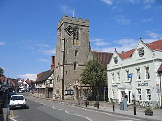
Henley-in-Arden is a market town and civil parish in the Stratford-on-Avon District in Warwickshire, England. The town takes its last name from the former Forest of Arden. Henley is known for its variety of historic buildings, some of which date back to medieval times, and its wide variety of preserved architectural styles. The one-mile-long (1.6 km) High Street is a conservation area.

The Meriden Gap is a mostly rural area in the West Midlands between Solihull and Coventry. It is a part of the wider West Midlands Green Belt, separating Coventry from the large West Midlands conurbation, which includes Birmingham and Wolverhampton. The 'Gap' takes its name from the village central to the area, Meriden, although the largest settlement is Balsall Common. The highest point lies at 181 metres (594 ft) above sea level, slightly north of the hamlet of Eaves Green near the West Midlands-Warwickshire border.

<span class="mw-page-title-main">Olton</span> Human settlement in England

Olton is an area/suburban village within the Metropolitan Borough of Solihull in the West Midlands, England. In the 13th century, the Lords of the Manor moved their seat and formed a new settlement, at the junction of two major roads. It was then that Ulverlei was being referred to as ‘Oulton’ to distinguish itself from nearby Solihull. Historically within the county of Warwickshire, the village has gradually become contiguous with Solihull to the southeast, though it retains the character of a large independent village.

<span class="mw-page-title-main">Bickenhill</span> Village in West Midlands, England

Bickenhill is a village in the civil parish of Bickenhill and Marston Green, in the Metropolitan Borough of Solihull, in the West Midlands county, England, on the eastern fringe of the West Midlands conurbation. Bickenhill is also a ward and was within the historic county of Warwickshire. Birmingham Airport is also located within the civil parish.

<span class="mw-page-title-main">Hockley Heath</span> Human settlement in England

Hockley Heath is a large village and civil parish in the Arden area mostly within the Metropolitan Borough of Solihull, West Midlands, England. It incorporates the hamlet of Nuthurst, and has a history dating back to the year 705 AD as a wood owned by Worcester Cathedral. The parish, known as Nuthurst cum Hockley Heath, is to the south of the West Midlands conurbation, 12 miles (19 km) southeast of Birmingham 5.5 miles (8.9 km) from Solihull town centre and 13 miles (21 km) north of Stratford-upon-Avon. The village forms part of the border with Warwickshire and the District of Stratford-on-Avon to the south, with some parts of the village on either side of the border. According to the 2001 census, the parish had a population of 6,771, being measured at the 2011 Census as 2,038.

<span class="mw-page-title-main">Tanworth-in-Arden</span> Human settlement in England

Tanworth-in-Arden is a village and civil parish in the county of Warwickshire, England. It is 12.5 miles (20 km) south-southeast of Birmingham, 5.5 miles (9 km) north-east of Redditch and 8 miles south-southwest of Solihull and is administered by Stratford-on-Avon District Council. Situated in the far west of the county and close to the Worcestershire border, the civil parish is larger than the village, and includes Tanworth-in-Arden itself plus the nearby settlements of Earlswood, Wood End, Forshaw Heath, Aspley Heath and Danzey Green. The population of the parish was 3,228 at the 2021 UK census.

<span class="mw-page-title-main">Sambourne</span> Village and civil parish in Warwickshire, England

Sambourne, formerly spelled Sambourn, is a village and civil parish 1.5 miles (2.4 km) north-west of Coughton, 4.5 miles (7.2 km) south of Redditch, 12 miles (19 km) north-west of Stratford-upon-Avon and 20 miles (32 km) west of Warwick in the county of Warwickshire, England. It is situated on sloping ground rising westwards to about 500 feet near the ancient Ridge Way, and forms part of the county boundary with Worcestershire. The village itself is centred round a small triangular green at the junction of four roads and contains several timber-framed buildings of 17th century date. By a designation of 22 July 1991 much of the central area became a conservation area.

<span class="mw-page-title-main">Soulton Hall</span> Sir Rowland Hills Tudor headquarters in, Shropshire, UK

Soulton Hall is a Tudor country house near Wem, England. It was a 16th century architectural project of Sir Rowland Hill, publisher of the Geneva Bible. Hill was a statesman, polymath and philanthropist, later styled the "First Protestant Lord Mayor of London" because of his senior role in the Tudor statecraft that was needed to bring stability to England in the fall out of the Reformation. The building of the current Soulton Hall, undertaken during the tumult of the Reformation, is therefore associated with the political and social work required to incubate the subsequent English Renaissance.

<span class="mw-page-title-main">Arden family</span> English gentry family

The Arden family is an English gentry family that can be traced back in the male line to Anglo-Saxon landholders who managed to maintain status after the 1066 invasion of England by the Normans of France.

<span class="mw-page-title-main">Solihull</span> Town in West Midlands, England

Solihull is a market town and the administrative centre of the Metropolitan Borough of Solihull, in the West Midlands, England. Solihull is situated on the River Blythe in the Forest of Arden area. The town had a population of 126,577 at the 2021 Census, and its wider borough had a population of 216,240. The town is located 8 miles (12 km) southeast of Birmingham and 13 miles (21 km) west of Coventry.

<span class="mw-page-title-main">Stoke on Tern</span> Village in Shropshire, England

Stoke on Tern is a village located in Shropshire, England, on the River Tern. The civil parish is known as Stoke upon Tern.

<span class="mw-page-title-main">Coughton, Warwickshire</span> Village in Warwickshire, England

Coughton is a small village located between Studley 2.4 miles (4 km) to the North and Alcester, 2 miles (3 km) to the South, in the county of Warwickshire, England. The village lies 19.3 miles (31 km) from Birmingham on the Birmingham–Alcester A435 road, which here follows the line of the Roman road Icknield Street. The village mainly consists of a number of houses on Sambourne Lane, Coughton Lane and farms and is primarily noted as being the location of the National Trust property, Coughton Court, which lies 400 yards to the east of the A435. The population according to the 2001 Census was 139, increasing to 157 in the 2011 Census.

<span class="mw-page-title-main">Ladbrooke, Tanworth-in-Arden</span>

Ladbrooke is an historic estate in the parish of Tanworth-in-Arden, Warwickshire, England. The early history until the late 14th century is sparse and inextricably confused with the manor and parish of Ladbroke near Southam in Warwickshire, 34 km to the south-east. The confusion arises not only because both places within the same county are spelled variously and identically in historic documents, but mainly because the mediaeval de Lodbroke family appear to have held estates in each place. The 1619 Heraldic Visitation of Warwickshire which gives the pedigree of the "de Lodbroke" family, states them as "Dominus de Lodbrooke" and makes no mention of Tanworth-in-Arden. The Victoria County History is however clear that the seat of the de Lodbroke family was Ladbroke near Southam and not Ladbrooke in the parish of Tanworth-in-Arden.

<span class="mw-page-title-main">Monkspath</span>

Monkspath is a large residential community and light-industrial area of Solihull, West Midlands, England, southeast of the town's Shirley district. Monkspath is in the Blythe ward of the Metropolitan Borough of Solihull.

Earlswood is a small village in Warwickshire, England in the Tanworth-in-Arden Civil parish of the Stratford-on-Avon District. However, the northernmost part of the village lies within Tidbury Green parish in the Solihull Metropolitan Borough of the West Midlands. A hamlet called Warings Green also lies in the south east of the village, with the northernmost point crossing into the parish of Cheswick Green in the borough of`Solihull. The village's postal code, B94, is in the Birmingham postcode area. It is in the ecclesiastical parish of St Patrick, Salter Street. The village is surrounded by farmland and forests and it gives its name to Earlswood Lakes as well as to Earlswood railway station, even though The Lakes railway station is located closer to the main part of the village.

References

Notes

  1. 1 2 "Bodleian Library MS. Gough Gen. Top. 16". digital.bodleian.ox.ac.uk. Retrieved 6 November 2023.
  2. Wem Rural Parish Council https://www.wemrural-pc.gov.uk/wems-shakespearean-connection-old-sir-rowland-unmasked/
  3. https://www.shropshirestar.com/news/local-hubs/shrewsbury/2024/02/23/reasons-why-shropshire-should-celebrate-its-very-own-day-named-after-the-countys-patron-saint/
  4. Austin, Sue (8 November 2023). "Shropshire's remarkable connections with Shakespeare are fascinating". www.shropshirestar.com. Retrieved 9 November 2023.
  5. "Forest of Arden". 8 February 2012. Archived from the original on 8 February 2012. Retrieved 8 July 2023.
  6. Martineau, P. E. (1927). "The Forest of Arden". Empire Forestry Journal. 6 (2): 197–201. ISSN   2054-7447.
  7. 1 2 "Forest of Arden – Encyclopedia". theodora.com. Retrieved 6 December 2023.
  8. Pawlowski, Anna (24 October 2023). "St James' Church Is A Neo-Classical Architectural Gem Sitting On The Packington Estate In Coventry". Secret Birmingham. Retrieved 6 November 2023.
  9. "Dog trials". Packington Estate. Retrieved 6 November 2023.
  10. Ross, James (20 November 2020). "Greater Landowners and the Management of their Estates in Late Medieval England". The Fifteenth Century XVIII: 93–104. doi:10.1017/9781800101128.009.
  11. https://eservices.solihull.gov.uk/mginternet/documents/s98686/20220310_Solihull%20CA%20App%20and%20Manage%20Plan%20Draft_CPHReport_Appendix1.pdf.pdf
  12. Webb 2008.
  13. 1 2 3 Roberts, B. K. (1968). "A Study of Medieval Colonization in the Forest of Arden, Warwickshire". The Agricultural History Review. 16 (2): 101–113. JSTOR   40273280.
  14. https://commons.wikimedia.org/wiki/File:Coughton_Cross_-_geograph.org.uk_-_4657750.jpg
  15. Dargue, William (2 May 2014). "Park Hall (Part One) – The Manor House". Birmingham History. Retrieved 2 November 2023.
  16. Enis, Cathryn (October 2016). "Edward Arden and the Dudley earls of Warwick and Leicester, c. 1572–1583". British Catholic History. 33 (2): 170–210. doi:10.1017/bch.2016.24. ISSN   2055-7973.
  17. Shapiro 2005, pp. 276–7.
  18. "Arden Hall Bredbury, Reddish Vale, Stockport | Artware Fine Art". www.artwarefineart.com. Retrieved 9 December 2023.
  19. Shapiro 2005, pp. 270–4.
  20. "August 2023". www.stmaryabchurch.org.uk. Retrieved 8 July 2023.
  21. "Archaeological dig unlocking the mysteries of historic site near Wem". Whitchurch Herald. 15 June 2023. Retrieved 8 July 2023.
  22. "Excavation resumes at Wem manor at the centre of medieval and Tudor history". Whitchurch Herald. 3 June 2023. Retrieved 8 July 2023.
  23. Tooley, David (14 June 2023). "Archaeologists coming closer to breaking the 'code' of ancient Shropshire hall which folklore links to Shakespeare". www.shropshirestar.com. Retrieved 8 July 2023.
  24. "The City of Coventry: The legend of Lady Godiva | British History Online". www.british-history.ac.uk.
  25. "Lottery grant for 'Tolkien' wood". 30 March 2010.
  26. "Step into Tolkien's world". 5 April 2016.
  27. "Arden Hill". History of Birmingham Places A to Y.
  28. "Finding Shakespeare's Forest of Arden | The Shakespeare blog".
  29. "The Historical Reality of Fantasy Forests: Arden, Sherwood, and Sambisa – as You Like It | Marin Shakespeare Company". 16 July 2014.
  30. Steven Falk (2011). "The Veteran Trees of Warwickshire" (PDF). ncr.com. Retrieved 15 September 2023.
  31. "Wild boar spotted in Warwickshire". 13 June 2011.
  32. "Special Landscape Areas Study" (PDF). stratford.gov.uk. June 2012. Retrieved 15 September 2023.
  33. "Heritage : Delving into Baddesley Clinton". 11 August 2011.
  34. "BGS Lexicon of Named Rock Units – Result Details".
  35. 1 2 "Where was Shakespeare's Forest of Arden?". National Trust.
  36. Felix Dennis leaves £500 million fortune to his forest 24 June 2014
  37. "Visit the forest | Heart of England Forest". heartofenglandforest.org.
  38. "1000s of trees and plans to 'rewild' land under Arden Forest plan". 5 February 2021.
  39. The Forest of Arden, Heart of England blog

Sources

Further reading