
Portland Street is a popular street in Kowloon, Hong Kong. The street is the location of the business and retailing skyscraper complex, Langham Place, numerous restaurants and its red-light district.

Kowloon is an urban area in Hong Kong comprising the Kowloon Peninsula and New Kowloon. It has a population of 2,019,533 and a population density of 43,033/km2 (111,450/sq mi) in 2006. It is one of the three regions of Hong Kong, along with Hong Kong Island and the New Territories, and is the smallest and most densely populated.

Mong Kok is an area in Kowloon, Hong Kong. The Prince Edward subarea occupies the northern part of Mong Kok.

Jordan is an area in Hong Kong, located on Kowloon Peninsula. It is named after a road of the same name in the district. The area is bordered by King's Park to the east, Tsim Sha Tsui to the south, Ferry Point to the west, and Yau Ma Tei to the north. Administratively, it is part of Yau Tsim Mong District.

Prince Edward is an area of Mong Kok south of Tong Mi surrounding Prince Edward station in Kowloon, Hong Kong. Named after Prince Edward Road West, the Prince Edward station of the MTR rapid transit system is an interchange station on the Tsuen Wan and the Kwun Tong lines.

Prince Edward is a station of the MTR rapid transit system in Hong Kong. It is located in Mong Kok, Kowloon, under the intersection of Nathan Road and Prince Edward Road West, after which it is named.

Mong Kok station is a MTR station in Mong Kok, Kowloon, Hong Kong. The station is one of the first MTR stations established in the city, serving Kwun Tong and Tsuen Wan line. It is now used by more than 200,000 passengers daily. The colour scheme for Mong Kok station is dim red. The station was initially named after Argyle Street as Argyle.

Ho Man Tin is a mostly residential area in Kowloon, Hong Kong, part of the Kowloon City District.

Nathan Road is the main thoroughfare in Kowloon, Hong Kong, aligned south–north from Tsim Sha Tsui to Sham Shui Po. It is lined with shops and restaurants and throngs with visitors, and was known in the post–World War II years as the Golden Mile, a name that is now rarely used. It starts on the southern part of Kowloon at its junction with Salisbury Road, a few metres north of Victoria Harbour, and ends at its intersection with Boundary Street in the north. Portions of the Kwun Tong and Tsuen Wan lines run underneath Nathan Road. The total length of Nathan Road is about 3.6 km (2.2 mi).

Mong Kok East station – formerly Mong Kok railway station and Yaumati railway station – is a station on Hong Kong's East Rail line. Only out-of-system interchange is available with Kwun Tong line and Tsuen Wan line at Mong Kok station via a footbridge. The station is connected to Grand Century Place, a large shopping mall.

Prince Edward Road East and Prince Edward Road West are roads in Kowloon, Hong Kong, going in an east-west direction and linking Tai Kok Tsui, Mong Kok, Kowloon Tong, Kowloon City and San Po Kong.
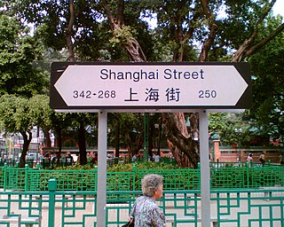
Shanghai Street is a 2.3 km long street in the Jordan, Yau Ma Tei and Mong Kok areas of Kowloon, Hong Kong, China. Completed in 1887 under the name of Station Street (差館街), it was once the most prosperous street in Kowloon. It originates from the south at Austin Road, and terminates in the north at Lai Chi Kok Road. Parallel to Shanghai Street are Nathan Road, Temple Street, Portland Street, Reclamation Street and Canton Road. Though parallel, Shanghai Street was marked by 2- to 3-floor Chinese-style buildings while Nathan Road was marked by Western-style buildings.
Canton Road is a major road in Hong Kong, linking the former west reclamation shore in Tsim Sha Tsui, Jordan, Yau Ma Tei, Mong Kok and Prince Edward on the Kowloon Peninsula. The road runs mostly parallel and west to Nathan Road. It starts from the junction with Salisbury Road in the south and ends in the north at the junction with Lai Chi Kok Road in the Prince Edward area. The southern section of Canton Road is home to many upscale retail shops, shopping centres and others business establishments, with busy traffic from both vehicles and pedestrians from morning till late at night.

Sai Yeung Choi Street are two streets in Mong Kok, Kowloon, Hong Kong, namely, Sai Yeung Choi Street South (西洋菜南街) and Sai Yeung Choi Street North (西洋菜北街). Although officially two streets, local people seldom make distinction between them. They are separated by the Mong Kok Police Station. Sai Yeung Choi Street South is a popular hotspot for shopping and a tourist attraction.

Soy Street is a street in Mong Kok, Kowloon, Hong Kong. It starts from Tak Cheong Street in the west, crosses several major streets including Nathan Road, and ends near Waterloo Road.
Articles related to Hong Kong include:

Nelson Street is a street in Mong Kok, Kowloon, Hong Kong, China. The street is 240 metres in length and runs in the east–west direction. It can be accessed from exits E1 and E2 of the Mong Kok station. The section between Portland and Sai Yeung Choi South Street is closed to vehicular traffic.


