Related Research Articles

Northwood is an area in the London Borough of Hillingdon, located 14.5 miles (23.3 km) north-west of Charing Cross. Northwood was part of the ancient parish of Ruislip, Middlesex. The area was situated on the historic Middlesex boundary with Hertfordshire, and since being incorporated into Greater London in 1965, has been on the Greater London boundary with that county.
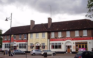
Elm Park is a suburban planned community in East London and part of the London Borough of Havering. Located 14.3 miles (23.0 km) east-northeast of Charing Cross, it is identified as a district centre in the London Plan with several streets of shops and a priority for regeneration. Prior to the construction of the extensive Elm Park Garden City development in the 1930s it was a scattered settlement of farms in the south of the parish of Hornchurch. Elm Park has been connected to central London by the electrified District line service since 1935 and the planned development of the area formed part of the interwar private housing boom that was interrupted by World War II. After the war Elm Park expanded with social housing and it has formed part of Greater London since 1965.

Cheltenham, also known as Cheltenham Spa, and sometimes called "the Garden Town of England", is a spa town on the edge of the Cotswolds in the county of Gloucestershire, England. It is also a local government district with borough status. Cheltenham became known as a health and holiday spa town resort, following the discovery of mineral springs in 1716, and claims to be the most complete Regency town in Britain.

Newton Aycliffe is a town in County Durham, England. Founded in 1947 under the New Towns Act of 1946, the town is 5 miles to the north of Darlington and 10 miles to the south of Durham. It is the oldest new town in the north of England. Together with the bordering Aycliffe Village and the north part of School Aycliffe, it forms the civil parish of Great Aycliffe. The population of the town at the time of the 2011 census was 26,633.

Cheltenham is a suburb in Melbourne, Victoria, Australia, 18 km south-east of Melbourne's Central Business District, located within the Cities of Bayside and Kingston local government areas. Cheltenham recorded a population of 23,992 at the 2021 census.

Eastcote is a suburban area in the London Borough of Hillingdon, in west London.

Middleton is a largely residential suburb of Leeds in West Yorkshire, England and historically a village in the West Riding of Yorkshire. It is situated on a hill 4 miles (6 km) south of Leeds city centre and 165 miles (266 km) north north-west of London.

West Ealing is a district in the London Borough of Ealing, in West London. The district is about three-quarters of a mile (1.2 km) west of Ealing Broadway. Although there is a long history of settlement in the area, West Ealing in its present form is less than one hundred years old. West Ealing falls under the postcode district W13 and neighbours Hanwell, Ealing, Perivale and Northfields

Hartcliffe is the name of both a council ward and an Outer Suburb of the city of Bristol in the United Kingdom which lies within that ward. The ward contains the areas of Hartcliffe and Headley Park, as well as small portions of Withywood and Bishopsworth.

Cheltenham West is an area in the western part of Cheltenham, Gloucestershire, England. It is the generic name for an area which includes the council wards of Hesters Way, Springbank, Arle, Rowanfield, Alstone, Fiddlers Green, St Mark's and some of St Peter's and the Moors.
Lillington is a suburb of Leamington Spa, in the civil parish of Royal Leamington Spa, in the Warwick District in the county of Warwickshire, England. Historically a village which existed before the time of the Domesday Book (1086), it was incorporated into the borough of Leamington in 1890. Lillington is a ward of Warwick District Council and Royal Leamington Spa Town Council.
Longlevens, originally Longleavens, is a suburb of Gloucester, in Gloucestershire, England. It developed from a farmstead during the twentieth century, the name may be based on the old Roman name Colonia Glevensis, or the name could be based on an original field name "Long Elevens". This could have related to a long field about eleven acres therefore this could have been adopted as a name for the hamlet, first recorded in 1750, as part of the estate of Gloucester Cathedral. One of the oldest roads is 'The Avenue', which is shown on old maps as a number of farm cottages built in the 1850s. The population of Longlevens was 9,532 at the time of the 2011 Census.

Hogganfield is a district in the Scottish city of Glasgow, located to the north east of the city centre. Hogganfield is surrounded by the Glasgow districts of Blackhill, Craigend, Millerston, Provanmill, Riddrie, Robroyston, Ruchazie and Stepps. The M80, Stepps bypass, separates Hogganfield from Robroyston.
Rowanfield is a neighbourhood in Cheltenham, England. It consists primarily of a social housing estate of Wimpey no-fines houses and low-rise flats, built around 1953, with Rowanfield School and a playing field to the West separating it from Hesters Way and also the older Rowanfield Road to the East. To the south-west Rowanfield borders the district of St Mark's. Rowanfield is located 1.5 miles west of the centre of Cheltenham.

Leagrave is a former village and now a suburb of Luton, in the Luton district, in the ceremonial county of Bedfordshire, England, in the northwest of the town. The area is roughly bounded by Vincent Road, Torquay Drive and High Street to the north, Roman Road and Stoneygate Road to the south, the M1 to the west, and Marsh Road and Leagrave Park to the east.

Exhall is a village in the Nuneaton and Bedworth borough in Warwickshire, England. It forms part of the Coventry and Bedworth urban area and is contiguous with the Coventry suburb of Longford and the village of Hawkesbury Village.
Redditch is a town and local government district in north-east Worcestershire, England. The town is divided into separate districts. All street-name signs in Redditch have the street name in white lettering on a blue background and the district name in black lettering on a white background at the bottom of the sign. In the New Town areas the roads are usually named in alphabetical order and house numbering in the cul-de-sac closes is consecutive, starting with number 1 as the first house on the left as you enter, and the highest house number will be on the opposite side of the road as you leave.
There are various formal and informal subdivisions of London Borough of Barking and Dagenham and of parts of that borough.

The Doughnut is the nickname given to the headquarters of the Government Communications Headquarters (GCHQ), a British cryptography and intelligence agency. It is located on a 71 hectares site in Benhall, in the suburbs of Cheltenham, Gloucestershire, in South West England. The Doughnut accommodates 5,500 employees; GCHQ is the largest single employer in Gloucestershire. Built to modernise and consolidate GCHQ's multiple buildings in Cheltenham, the Doughnut was completed in 2003, with GCHQ staff moving in the same year, and fully moved into the building in 2004. It is the largest building constructed for secret intelligence operations outside the United States.

Cheltenham Township is a Home Rule Municipality and Township of the First Class located in the southeast corner of Montgomery County, Pennsylvania, United States. It borders the City of Philadelphia to the south and east, Abington Township and the borough of Jenkintown to the north, and Springfield Township to the west.
References
- 1 2 "Cheltenham Ward population 2011" . Retrieved 27 October 2015.
- ↑ "About Us". Archived from the original on 18 February 2010. Retrieved 21 June 2010.