Berkeley Hills

Last updated
Berkeley Hills
Grizzly Bench.jpg
Highest point
Elevation 581 m (1,906 ft)
Geography
Relief map of California.png
Red triangle with thick white border.svg
Location of Berkeley Hills in California [1]
CountryUnited States
StateCalifornia
District Alameda County
Range coordinates 37°52′58″N122°14′16″W / 37.88278°N 122.23778°W / 37.88278; -122.23778
Topo map USGS  Briones Valley

The Berkeley Hills are a range of the Pacific Coast Ranges that overlook the northeast side of the valley that encompasses San Francisco Bay. They were previously called the "Contra Costa Range/Hills" [2] [3] (from the original Spanish Sierra de la Contra Costa), but with the establishment of Berkeley and the University of California, the current usage was applied by geographers and gazetteers.

Contents

Geology

The Berkeley Hills are bounded by the major Hayward Fault along their western base, and the minor Wildcat fault on their eastern side. The highest peaks are Grizzly Peak (elevation 1,754 feet/535 m) and Round Top (elevation 1,761 feet/537 m), an extinct volcano, and William Rust Summit 1,004 feet (306 m).

Vollmer Peak (elevation 1,905 feet/581 m), although commonly thought to be part of the Berkeley Hills, is actually located on the adjacent San Pablo Ridge [ dubious ] near the point where it meets the Berkeley Hills at the head of Wildcat Canyon. Vollmer Peak was named in honor of the first police chief of the City of Berkeley, August Vollmer. It was formerly known as "Bald Peak", and as "Rocky Mound" [4] in the 19th century.

Development

Much of the west slope of the Berkeley Hills has residential neighborhoods of mostly single family homes, except on the land of University of California, Berkeley. Most streets are narrow and tend to follow the contours of the land, although three streets, Marin Avenue, Moeser Lane, and Potrero Avenue, run directly toward the ridgeline. Other roads to the ridgeline wind their way up the canyons. Grizzly Peak and Skyline Boulevards follow the top of the ridge. Many neighborhoods in the Berkeley Hills are home to the more affluent residents of Berkeley and Oakland.

The east slope of the Berkeley Hills is mostly preserved or partially developed wildland, much of it owned by the East Bay Regional Park District and the East Bay Municipal Utility District (EBMUD). From north to south, the parks are Wildcat Canyon Regional Park, Tilden Regional Park (includes Vollmer and Grizzly Peaks), Sibley Volcanic Regional Park (includes Round Top), Huckleberry Botanic Regional Preserve, Redwood Regional Park (enfolding Roberts Regional Recreation Area), Anthony Chabot Regional Park, Lake Chabot Regional Park, and Cull Canyon Regional Recreation Area. Claremont Canyon Regional Preserve, and Temescal Regional Park are lower on the western slopes while Las Trampas Regional Wilderness is lower on the eastern slope above Danville.

The Berkeley Hills are pierced by several tunnels. The Claremont Tunnel brings water from an EBMUD treatment plant in Orinda to points west. The Berkeley Hills Tunnel serves the Yellow Line of the Bay Area Rapid Transit (BART) system. The four bores of the Caldecott Tunnel carry State Highway 24 between Oakland and Contra Costa County.

The Berkeley Hills as seen from CA 24 near Orinda. Berkeley Hills Orinda.jpg
The Berkeley Hills as seen from CA 24 near Orinda.
Oakland and the Bay from Grizzly Peak Blvd. Dusk in the Oakland Hills - Flickr - Joe Parks.jpg
Oakland and the Bay from Grizzly Peak Blvd.

Usage

It is common to hear the term "Oakland Hills" to refer to that section of the Berkeley Hills that runs along the east side of Oakland. As a proper name or recognized toponym, it is technically incorrect. When used on maps, the exact south end of the "Berkeley Hills" is unclear, but the maps of the USGS show them stretching well south into the northeastern portion of Oakland. [5] It does not, in any case, correspond to any political boundaries, only to a geographic feature (much as "San Francisco Bay" is not limited to that stretch of the Pacific inlet within the bounds of the City and County of San Francisco). The ridge extends south through Oakland and San Leandro to the drainage of San Leandro Creek called Castro Valley, and geologically, continues southward above the line of the Hayward Fault. In the section above East Oakland to Castro Valley, the ridge appears on most maps as the San Leandro Hills. [6]

The northern extent of the proper name "Berkeley Hills" is less indefinite; most maps including those of the USGS apply the name along the entire ridge as it runs continuously right up to the mouth of Wildcat Canyon in Richmond. [7] The eastern slopes of the Berkeley Hills lie entirely outside of the city of Berkeley within Contra Costa County.

Another common usage is East Bay Hills, but its application to any particular range is unclear. It may refer to all of the ranges east of the Bay, from the Berkeley Hills to the Diablo Range and all the ranges between.

Ecology

The Berkeley Hills are a region of great biological diversity as part of Pacific Coastal Region of California and the San Francisco Bay ecosystem. Much of the area is covered by grassland which favors the southwest facing slopes. Amongst the north east hills, Baccharis Brushland and Oak Woodland are most prominent with Coast live oak and California bay laurel as some of the most prolific trees. Past Eucalyptus tree farming during the early 20th century has also introduced large Eucalyptus groves scattered across the Berkeley Hills. [8]

The area welcomes a wide variety of birds, lack-tailed deer, coyote, ground squirrel, striped skunk, western terrestrial garter snake, gray fox, bobcat, and red-tailed hawk. There are also periodic sightings of mountain lions amongst the Oak Woodland. Four protected species also call the Berkeley Hills their home, the San Francisco tree lupine moth, Alameda whipsnake, Callippe silverspot, and Bay checkerspot. Additionally, the grassland acts as an annual foraging spot for the northern harrier, American kestrel, prairie falcon, and turkey vulture.

Climatic effects

The Berkeley Hills affect the local climate by their elevation. The oceanic marine layer, which develops during the summer, bringing fog and low clouds with it, is usually less than 2,000 feet deep and thus is blocked by the range. This produces a "fog shadow" effect to the east, which is warmer than areas west of the hills. The westerly wind that carries the marine layer through the Golden Gate typically splits its flow as it hits the Berkeley Hills producing a southerly wind from Berkeley northward and a northerly wind in the direction of Oakland.

In winter during spells of tule fog inland, a reverse situation occurs, with the fog usually confined to areas east of the hills, although occasionally, the inland fog pours in from the north, around the hills by way of the Carquinez Strait.

The Berkeley Hills affect rainfall; when the wind is perpendicular to the hills (southwest wind) during a storm, air is forced to rise, cooling and condensing additional moisture, increasing the precipitation on the western slopes and leaving areas east of the hills drier. Especially cold storms occasionally deposit wet snow on the peaks.

In spring and fall, sinking air from aloft combining with inland high pressure periodically sends the Diablo wind, a hot, dry, and gusty wind across the ridges of the Berkeley Hills, posing a fire danger, which in the 20th century produced several wildfires, two of which caused major damage to Berkeley and Oakland. (See 1923 Berkeley Fire and 1991 Oakland firestorm).

Related Research Articles

<span class="mw-page-title-main">Diablo wind</span> Northern California weather pattern

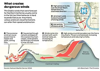
Diablo wind is a name that has been occasionally used for the hot, dry wind from the northeast that typically occurs in the San Francisco Bay Area of Northern California, during the spring and fall.

<span class="mw-page-title-main">Tilden Regional Park</span> Public park in California

Charles Lee Tilden Regional Park, also known as Tilden Park or Tilden, [], is a 2,079-acre (841 ha) regional park in the East Bay, part of the San Francisco Bay Area in California. It is between the Berkeley Hills and San Pablo Ridge. Its main entrance is near Kensington, Berkeley, and Richmond. The park is contiguous with Wildcat Canyon Regional Park.

<span class="mw-page-title-main">East Bay Regional Park District</span> Special District in Alameda and Contra Costa Counties, California

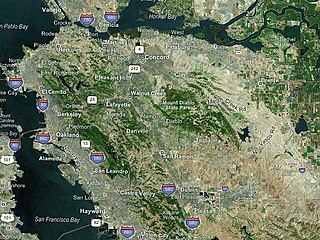
The East Bay Regional Park District (EBRPD) is a special district operating in Alameda County and Contra Costa County, California, within the East Bay area of the San Francisco Bay Area. It maintains and operates a system of regional parks which is the largest urban regional park district in the United States. The administrative office is located in Oakland.

<span class="mw-page-title-main">Caldecott Tunnel</span> Four-bore passage for CA SR 24 under the Berkeley Hills

The Caldecott Tunnel is an east–west highway tunnel through the Berkeley Hills between Oakland and Orinda, California. Its four bores carry California State Route 24. Named after Thomas E. Caldecott, former mayor of Berkeley, it opened in 1937 as a two-bore tunnel. The third bore opened in 1964 and the fourth bore in 2013. Currently, the two oldest bores carry eastbound traffic and the two newest bores carry westbound traffic.

Canyon, formerly known as Sequoya, is an unincorporated community located near the border of Contra Costa and Alameda counties, in the U.S. state of California. It is situated between Oakland and Moraga in the San Francisco Bay Area. The community is named for its location in the upper canyon of San Leandro Creek along the eastern slope of the Berkeley Hills. Canyon lies at an elevation of 1138 feet.

<span class="mw-page-title-main">East Bay</span> Eastern region of the San Francisco Bay Area, California, US

<span class="mw-page-title-main">Montclair, Oakland, California</span> Neighborhood of Oakland in Alameda, California, United States

Montclair is a hillside neighborhood in Oakland, California, United States. Montclair is located along the western slope of the Oakland Hills from a valley formed by the Hayward Fault to the upper ridge of the hills.

<span class="mw-page-title-main">Wildcat Canyon Regional Park</span>

Wildcat Canyon Regional Park is a 2,789-acre (1,129 ha) East Bay Regional Parks District park bordering the city of Richmond in Contra Costa County in the San Francisco Bay Area of California. It includes a portion of Wildcat Canyon as well as a portion of the adjoining San Pablo Ridge, and is directly connected to the more heavily used Tilden Regional Park.

Wildcat Canyon is a narrow linear valley just east of the Berkeley Hills in the San Francisco Bay Area, situated in Contra Costa County, California. The canyon is bounded on its east side by the San Pablo Ridge, and is drained by Wildcat Creek which runs northwest to its outlet in San Pablo Bay. Two minor lakes or ponds lie along the creek: Jewel Lake and Lake Anza. The latter was enlarged by the construction of a small dam in the mid-20th century. An active tectonic fault, the Wildcat Fault, runs the length of the canyon. Wildcat Canyon was named for the mountain lions which used to be fairly common in the area. The southern end of the canyon adjacent to the city of Berkeley was incorporated into Tilden Regional Park in the 1930s and remains a major recreation area for local residents. Another regional park, Wildcat Canyon Regional Park, is situated at the northern end of the canyon.

<span class="mw-page-title-main">Briones Regional Park</span>

Briones Regional Park is a 6,117-acre (24.75 km2) regional park in the East Bay Regional Park District (EBRPD) system, located in the Briones Hills of central Contra Costa County of the San Francisco Bay Area in California.

<span class="mw-page-title-main">Robert Sibley Volcanic Regional Preserve</span> Nature preserve in the San Francisco Bay Area

Robert Sibley Volcanic Regional Preserve is located in the Oakland Hills of the East Bay region of the San Francisco Bay Area, California. The park is part of the East Bay Regional Parks District (EBRPD), covers 928 acres (3.76 km2), and lies east of Oakland, partly in Alameda County and partly in Contra Costa County. It can be entered from Oakland via Skyline Boulevard, or from Contra Costa County via Old Tunnel Road.

<span class="mw-page-title-main">Wildcat Creek (California)</span> River in California, United States

Wildcat Creek is a 13.4-mile-long (21.6 km) creek which flows through Wildcat Canyon situated between the Berkeley Hills and the San Pablo Ridge, emptying into San Pablo Bay in Contra Costa County, northern California.

<span class="mw-page-title-main">Pinole Creek</span> River in California, United States

Pinole Creek is a stream in western Contra Costa County, in the East Bay region of the San Francisco Bay Area, California.

<span class="mw-page-title-main">Oakland Hills, Oakland, California</span> Neighbourhood region in Oakland, California

<span class="mw-page-title-main">Moraga Formation</span> Pliocene geological formation in California

The Moraga Formation, also known as the Moraga Volcanics, is geological formation that dates back to the Pliocene epoch. It is located in Berkeley Hills, East Bay Region, San Francisco Bay Area, California.

The Giant Powder Company was an explosives manufacturing company which operated from the mid 19th century through the first half of the 20th century, located in the San Francisco Bay Area of California. The Giant Powder Company was the first company in the United States to produce dynamite under an exclusive license from Alfred Nobel.

<span class="mw-page-title-main">East Bay Redwoods</span> Isolated population of coast redwoods

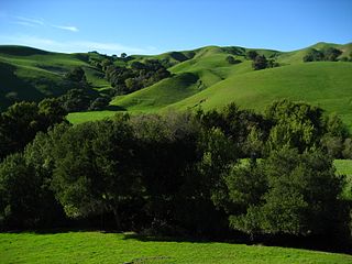
The East Bay Redwoods are an isolated population of coast redwoods that exist a considerable distance inland from the coast in the Berkeley Hills in western Contra Costa County, California. Stands of Sequoia sempervirens, the Coast Redwood, occur on the west coast from Big Sur to extreme southwestern Oregon. Their preferred habitat is the temperate and perennially foggy western slopes of the California Coast Ranges; a reliance on marine climates generally restricts their range to a narrow band along the central and northern coasts of California.

<span class="mw-page-title-main">Las Trampas Peak</span> Mountain in SF Bay Area Coast Ranges

Las Trampas Peak is a 1,827 ft (557 m) peak in the Inner Coast Ranges in western Contra Costa County, California, in the San Francisco Bay Area.

<span class="mw-page-title-main">Rocky Ridge, California</span> Mountain in SF Bay Area

Rocky Ridge is a 2,020 ft (620 m) ridge in the Inner Coast Ranges in western Contra Costa County, California, in the San Francisco Bay Area. Being the second-highest mountain in the county, it is visible from much of the surrounding area. The ridge is a very prominent feature in the geography of the towns of Lafayette, Moraga and Orinda, California.

References

Notes
  1. "Berkeley Hills". Geographic Names Information System . United States Geological Survey, United States Department of the Interior . Retrieved 2009-05-04.
  2. Engineers, United States Army Corps of (July 28, 1856). "Reports of Explorations and Surveys for a Railroad from the Mississippi River to the Pacific Ocean...1853-54". Archived from the original on July 28, 2022. Retrieved September 7, 2022 via Google Books.
  3. "The Atlantic, July 1874". The Atlantic . July 1874. Archived from the original on 2022-08-01. Retrieved 2022-08-01.
  4. "Topographical Map of Contra Costa County, Britton and Rey, 1871". Archived from the original on 2022-11-24. Retrieved 2022-11-24.
  5. "Oakland East Quadrangle 1973, USGS Topographic Map". Archived from the original on 2017-10-13. Retrieved 2017-10-13.
  6. "Las Trampas Ridge Quadrangle 1968, USGS Topographic Map". Archived from the original on 2017-10-13. Retrieved 2017-10-13.
  7. "San Francisco 15-minute Quadrangle 1895, USGS Topographic Map". Archived from the original on 2017-11-12. Retrieved 2017-11-12.
  8. Robles, Marcos, and F. S. Chapin. "Comparison of the influence of two exotic communities on ecosystem processes in the Berkeley Hills". Madroño, vol. 42, no. 3, California Botanical Society, 1995, pp. 349–57, Archived 2021-11-13 at the Wayback Machine .
Sources