
The Sahara desert, as defined by the World Wide Fund for Nature (WWF), includes the hyper-arid center of the Sahara, between latitudes 18° N and 30° N. It is one of several desert and xeric shrubland ecoregions that cover the northern portion of the African continent.
The climate of Mumbai is an extreme version of a tropical wet and dry climate with a lengthy, practically rainless dry season and a relatively short, but extremely rainy wet season due to the Southwest Monsoon and orographic influences from the nearby Western Ghats. Some suburbs are sufficiently wet to qualify as a tropical monsoon climate. Mumbai's climate can be best described as moderately hot with a high level of humidity. Its coastal nature and tropical location ensure temperatures do not fluctuate much throughout the year.

The climate of India consists of a wide range of weather conditions across a vast geographic scale and varied topography. Based on the Köppen system, India hosts six major climatic sub types, ranging from arid deserts in the west, alpine tundra and glaciers in the north, and humid tropical regions supporting rain forests in the southwest and the island territories. Many regions have starkly different microclimates, making it one of the most climatically diverse countries in the world. The country's meteorological department follows the international standard of four seasons with some local adjustments: winter, summer, monsoon or rainy season, and a post-monsoon period.

Singapore is an island city-state and country in maritime Southeast Asia, located at the end of the Malayan Peninsula between Malaysia and Indonesia as well as the Straits of Malacca and the South China Sea. It is heavily compact and urbanised. As of 2023, Singapore has a total land area of 734.3 square kilometres (283.5 sq mi). Singapore is separated from Indonesia by the Singapore Strait and from Malaysia by the Straits of Johor.

Bukit Panjang is a planning area and residential town located in the West Region of Singapore. A portion of this town is situated on a low-lying elongated hill. The planning area is bounded by Bukit Batok to the west, Choa Chu Kang to the northwest, Sungei Kadut to the north, the Central Water Catchment to the east and Bukit Timah to the south. Bukit Panjang New Town is located at the northern portion of the planning area. Bukit Panjang has an average elevation of 36m/118 ft.

The Bukit Timah Nature Reserve is a 1.7-square-kilometre (0.66 sq mi) nature reserve near the geographic centre of Singapore, located on the slopes of Bukit Timah Hill, the country's highest natural peak standing at a height of approximately 165 metres (541 ft), and parts of the surrounding area, located actually in Bukit Panjang. The nature reserve is about 15 kilometres from the Downtown Core, Singapore's central business district (CBD).

The Central Catchment Nature Reserve is the largest nature reserve in Singapore, occupying 2880 hectares. Forming a large green lung in the geographical centre of the city, it houses several recreational sites, including the Singapore Zoo, the Night Safari and the River Safari, as well as several newer facilities built to encourage public appreciation of the reserve, such as the HSBC TreeTop Walk. The reserve sits within the boundaries of the Central Water Catchment. It is one of the four gazetted nature reserves in Singapore. The other three are the Labrador Nature Reserve which was gazetted since 1 January 2002, Sungei Buloh Wetland Reserve and Bukit Timah Nature Reserve. All four nature reserves along with the parks are protected under the Parks & Trees Act 2005.

Penang Hill is a hill resort comprising a group of peaks near the center of Penang Island, Malaysia. It is located within the Air Itam suburb, 9 km (5.6 mi) west of the center of George Town. Penang Hill is also known by the Malay name Bukit Bendera, which actually refers to Flagstaff Hill, the most developed peak. One of the peaks is known as Strawberry Hill, which was also the name of a house owned by Francis Light, founder of Penang colony.

The Wuyi Mountains or Wuyishan are a mountain range located in the prefecture of Nanping, in northern Fujian province near the border with Jiangxi province, China. The highest peak in the area is Mount Huanggang at 2,158 metres (7,080 ft) on the border of Fujian and Jiangxi, making it the highest point of both provinces; the lowest altitudes are around 200 metres (660 ft). Many oolong and black teas are produced in the Wuyi Mountains, including Da Hong Pao and lapsang souchong, and are sold as Wuyi tea. The mountain range is known worldwide for its status as a refugium for several rare and endemic plant species, its dramatic river valleys, and the abundance of important temples and archeological sites in the region, and is a UNESCO World Heritage Site.

Mount Faber, formerly Telok Blangah Hill, is a hill about 94 metres (308 ft) in height, located in the town of Bukit Merah in the Central Region of Singapore. It overlooks the Telok Blangah area and the western parts of the Central Area. The summit is accessible by Mount Faber Road or Mount Faber Loop via Morse Road, but there are many footpaths or trails leading up the hill. The main paths are: Marang Trail, which leads from Marang Road at the Harbourfront MRT station, and the Southern Ridges Park Connector which connects from Telok Blangah Hill Park, Kent Ridge Park, and Henderson Waves.

Australia's climate is governed mostly by its size and by the hot, sinking air of the subtropical high pressure belt. This moves north-west and north-east with the seasons. The climate is variable, with frequent droughts lasting several seasons, thought to be caused in part by the El Niño-Southern Oscillation. Australia has a wide variety of climates due to its large geographical size. The largest part of Australia is desert or semi-arid. Only the south-east and south-west corners have a temperate climate and moderately fertile soil. The northern part of the country has a tropical climate, varying between grasslands and desert. Australia holds many heat-related records: the continent has the hottest extended region year-round, the areas with the hottest summer climate, and the highest sunshine duration.
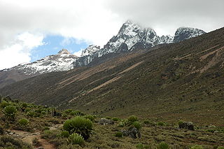
The climate of Mount Kenya has played a critical role in the development of the mountain, influencing the topography and ecology amongst other factors. The area around Mount Kenya is covered by a comparably large number of weather station data with long measurements series and thus the climate is well recorded. It has a typical equatorial mountain climate which Hedberg described as winter every night and summer every day.
The Bukit Timah Monkey Man, commonly abbreviated as BTM or BTMM, is a legendary creature said to inhabit Singapore, chiefly in the forested Bukit Timah region. The creature is often cited as a forest-dwelling hominid or primate, and is also accounted for as being immortal; however, its exact identity remains unknown, and its existence disputed. Documentation of the BTM is sparse and scattered; the creature is largely considered a product of local folklore.

Bukit Panjang MRT/LRT station is a Mass Rapid Transit (MRT) and Light Rail Transit (LRT) interchange station on the Downtown line (DTL) and the Bukit Panjang LRT line (BPLRT) in Singapore. Located in the namesake estate of Bukit Panjang, the station is at the junction of Upper Bukit Timah Road and Petir Road. The station serves the commercial buildings of Bukit Panjang Plaza, Hillion Mall and Junction 10. It forms a part of the Bukit Panjang Integrated Transport Hub (BPITH), which also contains a bus interchange.

Hillview is located in Upper Bukit Timah, Northwest Singapore. The neighbourhood overlooks Bukit Timah Hill, hence its name.
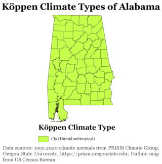
The state of Alabama is classified as humid subtropical (Cfa) under the Köppen climate classification. The state's average annual temperature is 64 °F (18 °C). Temperatures tend to be warmer in the state's southern portion with its proximity to the Gulf of Mexico, while its northern portions, especially in the Appalachian Mountains in the northeast, tend to be slightly cooler. Alabama generally has hot, humid summers and mild winters with copious precipitation throughout the year. The state receives an average of 56 inches (1,400 mm) of rainfall each year and experiences a lengthy growing season of up to 300 days in its southern portion. Hailstorms occur occasionally during the spring and summer here, but they are seldom destructive. Heavy fogs are rare, and they are confined chiefly to the coast. Thunderstorms also occur year-around. They are most common in the summer, but they are most commonly severe during the spring and late autumn. That is when destructive winds and tornadoes occur frequently, especially in the northern and central parts of the state. Central and northern Alabama are squarely within Dixie Alley, the primary area in the U.S. outside the Southern Plains with relatively high tornado risk. Alabama is ranked second in the U.S for the deadliest tornadoes. Hurricanes are quite common in the state, especially in the southern part. Major hurricanes occasionally strike the coast, such as Hurricane Frederic in September 1979 and Hurricane Ivan in September 2004; both storms resulted in significant to devastating damage in the Mobile area.
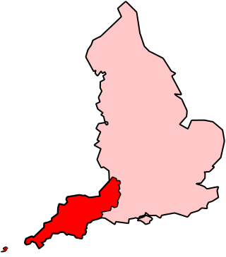
The climate of south-west England is classed as oceanic (Cfb) according to the Köppen climate classification. The oceanic climate is typified by frequent cloudy skies, cool winters with cool summers and precipitation all year round, with more experienced in winter. Annual rainfall is about 1,000 millimetres (39 in) and up to 2,000 millimetres (79 in) on higher ground. Exceptions include areas to the east of high ground ( e.g. Exeter / parts of West Somerset that are subject to a rain shadow effect and annual rainfall is closer to 30 inches.
Bukit Timah, is an area located within the Central Region of Singapore.

The Indian city of Thiruvananthapuram is located in Thiruvananthapuram district in the state of Kerala. The city is located at 8.5°N 76.9°E on the west coast, near the southern tip of mainland India. The city situated on the west coast of India, and is bounded by Arabian Sea to its west and the Western Ghats to its east. The city and the suburbs spans an area of 250 km2 (96.53 sq mi). The average elevation of the city is 16 ft above sea level. The highest point within the city limits is the observatory. Agastya Mala, which has an elevation of 1,868 metres (6,129 ft) is only about 60 km from the city. The Ponmudi hill station which has an elevation of 1,100 metres (3,609 ft) is also near the city.

The Eco-Link@BKE is an ecological bridge in Singapore which connects the Bukit Timah Nature Reserve with the Central Catchment Nature Reserve.


