
South Yorkshire is a ceremonial and metropolitan county governed as a combined authority in north-central England. It had a population of 1.34 million in 2011 and has an area of 1,552 square kilometres (599 sq mi). The county consists of four metropolitan boroughs—the City of Sheffield and the boroughs of Barnsley, Doncaster and Rotherham—collectively administered by a directly-elected mayor.

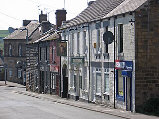
Barnsley is a market town in South Yorkshire, England. As the main settlement of the Metropolitan Borough of Barnsley and the fourth largest settlement in South Yorkshire, the 2011 Census gave the town a population of 91,297 compared to the wider borough which had a population of 246,866. Historically in the West Riding of Yorkshire, it is located between the cities of Sheffield, Manchester, Wakefield, and Leeds. The larger towns of Rotherham, Huddersfield and Doncaster are nearby.

The River Dearne South Yorkshire, England flows roughly east for more than 30 kilometres (19 mi), from its source just inside West Yorkshire. It flows through Denby Dale, Clayton West, Darton, Barnsley, Darfield, Wath upon Dearne, Bolton on Dearne, Adwick upon Dearne and Mexborough to its confluence with the River Don at Denaby Main. Its main tributary is the River Dove, which joins it at Darfield. The river was one of those affected by the 2007 United Kingdom floods.
Worsbrough is an area about two miles south of Barnsley in the metropolitan borough of Barnsley, South Yorkshire, England. Before 1974, Worsbrough had its own urban district council in the West Riding of the historic county of Yorkshire and it is still counted as a separate place from Barnsley by the 2011 Census, but it is often treated as part of Barnsley as the two settlements run into one another.

The Dearne and Dove Canal ran for almost ten miles through South Yorkshire, England from Swinton to Barnsley through nineteen locks, rising 127 feet (39 m). The canal also had two short branches, the Worsbrough branch and the Elsecar branch, both about two miles long with reservoirs at the head of each. The Elsecar branch also has another six locks. The only tunnel was bypassed by a cutting in 1840.

Wath upon Dearne is a town south of the River Dearne in the Metropolitan Borough of Rotherham, South Yorkshire, England, 5 miles (8 km) north of Rotherham and almost midway between Barnsley and Doncaster. It had a population of 11,816 at the 2011 census. It is twinned with Saint-Jean-de-Bournay in France.

RSPB Dearne Valley Old Moor is an 89-hectare (220-acre) wetlands nature reserve in the Dearne Valley near Barnsley, South Yorkshire, run by the Royal Society for the Protection of Birds (RSPB). It lies on the junction of the A633 and A6195 roads and is bordered by the Trans Pennine Trail long-distance path. Following the end of coal mining locally, the Dearne Valley had become a derelict post-industrial area, and the removal of soil to cover an adjacent polluted site enabled the creation of the wetlands at Old Moor.

Denaby Main is a village situated between Mexborough and Conisbrough in the Metropolitan Borough of Doncaster in South Yorkshire, England. The village falls within the Doncaster MBC ward of Conisbrough and Denaby. It was built by the Denaby Main Colliery Company to house its workers and their families, and originally given the name Denaby Main Colliery Village, to distinguish it from the village of Denaby, about ⅔ mile away on the road to Hooton Roberts and Kilnhurst; from that time, the old village became known as Old Denaby. In due course the "Colliery Village" part of the name was lost, leaving the village to be known as Denaby Main.
Wath Main Colliery was a coal mine situated in the Dearne Valley, close by the township of Wath-upon-Dearne, South Yorkshire, England. The colliery was operated by the Wath Main Coal Company Limited.

Barnburgh Main Colliery was a coal mine situated on the outskirts of the village of Barnburgh, about two miles north of Mexborough in the Dearne Valley, South Yorkshire, England. The sinking of the colliery was commenced in 1911 by the Manvers Main Colliery Company of Wath-upon-Dearne.

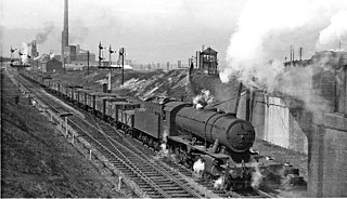
Wath marshalling yard, also known as Wath concentration yard, was a large railway marshalling yard specifically designed for the concentration of coal traffic. It was set at the heart of the South Yorkshire Coalfield, at Wath-upon-Dearne, approximately halfway between Barnsley and Doncaster, in the United Kingdom. It opened in 1907 and closed in 1988.

The A6195 road runs through the Dearne Valley in South Yorkshire, England.

The South Pennines is a region of moorland and hill country in northern England lying towards the southern end of the Pennines. In the west it includes the Rossendale Valley and the West Pennine Moors. It is bounded by the Greater Manchester conurbation in the west and the Bowland Fells and Yorkshire Dales to the north. To the east it is fringed by the towns of West Yorkshire whilst to the south it is bounded by the Peak District. The rural South Pennine Moors constitutes both a Site of Special Scientific Interest and Special Area of Conservation.
The South Yorkshire Coalfield is so named from its position within Yorkshire. It covers most of South Yorkshire, West Yorkshire and a small part of North Yorkshire. The exposed coalfield outcrops in the Pennine foothills and dips under Permian rocks in the east. Its most famous coal seam is the Barnsley Bed. Coal has been mined from shallow seams and outcrops since medieval times and possibly earlier.

The Dearne District Light Railway was a tramway linking Barnsley with the towns of Wombwell, Wath, Bolton on Dearne and Thurnscoe. Opened on 14 July 1924, it was the last street tramway to be built in the UK before the modern era and one of the first to shut. It was granted a Light Railway order in 1915, but World War I delayed its opening.

The A6023 road runs for 5.5 miles (8.9 km) from Conisbrough to Wath-upon-Dearne via Mexborough and Denaby Main. In the east, it starts at, and passes Conisbrough Castle.

The River Dove is a river that extends through the Low Valley in Barnsley, England. It flows from Worsbrough Reservoir to its confluence with the River Dearne.
Manvers Main Colliery was a coal mine, sunk on land belonging to the Earl Manvers on the northern edge of Wath-upon-Dearne, between that town and Mexborough in the Dearne Valley, in the West Riding of Yorkshire, England. The regional headquarters and laboratories of British Coal were situated in the complex.

National Cycle Network (NCN) Route 62 is a Sustrans National Route that runs from Fleetwood to Selby. As of 2018 the route has a missing section between Preston and Southport but is otherwise open and signed.
