
Durham is a cathedral city and civil parish in the county of Durham, England. It is the county town and contains the headquarters of Durham County Council, the unitary authority which governs the district of County Durham. It had a population of 48,069 at the 2011 Census.

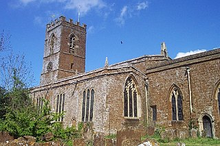
Llantwit Major is a town and community in Wales on the Bristol Channel coast. It is one of four towns in the Vale of Glamorgan, with the third largest population after Barry and Penarth, and ahead of Cowbridge. It is 4+1⁄2 miles (7.2 km) from Cowbridge, 9 miles (14 km) from Bridgend, 10 miles (16 km) from Barry, and 15 miles (24 km) from Cardiff. It had a population of 9,530 in 2021.

Dunster is a village and civil parish in Somerset, England, within the north-eastern boundary of Exmoor National Park. It lies on the Bristol Channel 2.5 miles (4 km) southeast of Minehead and 20 miles (32 km) northwest of Taunton. At the 2011 Census, it had a population of 817.

Pittington is a village and civil parish in County Durham, in England. It is situated a few miles north-east of Durham. The population as taken at the 2011 census was 2,534.

The Manchester Assize Courts was a building housing law courts on Great Ducie Street in the Strangeways district of Manchester, England. It was 279 ft (85 m) tall and from 1864 to 1877 the tallest building in Manchester. Widely admired, it has been referred to as one of Britain's 'lost buildings'. It was severely damaged by wartime bombing in the Manchester Blitz, and then the remains were demolished in 1957.

Aberford is a village and civil parish on the eastern outskirts of the City of Leeds in West Yorkshire, England. It had a population of 1,059 at the 2001 census, increasing to 1,180 at the 2011 Census. It is situated 10 miles (15.5 km) east, north east of Leeds and west of the A1(M) motorway.
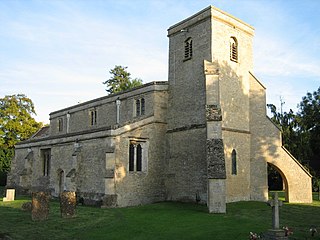
Swalcliffe is a village and civil parish about 5 miles (8 km) west of Banbury in Oxfordshire. The parish is about 2+1⁄2 miles (4 km) long north–south and about 1 mile (1.6 km) east–west. The 2011 Census recorded the population of the modern Swalcliffe parish as 210. The toponym "Swalcliffe" comes from the Old English swealwe and clif, meaning a slope or cliff frequented by swallows. The ancient parish of Swalcliffe was larger than the present civil parish, and included the townships of East Shutford, Epwell, Sibford Ferris, Sibford Gower and West Shutford.

Durham School is a fee-charging boarding and day school in the English public school tradition located in Durham, North East England. Since 2021 it has been part of the Durham Cathedral Schools Foundation.
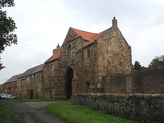
Kepier Hospital was a medieval hospital at Kepier, Durham, England.
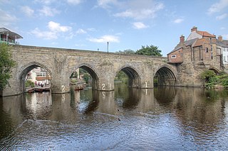
Elvet Bridge is a medieval masonry arch bridge across the River Wear in the city of Durham, in County Durham, England. It links the peninsula in central Durham and the Elvet area of the city, and is a Grade I listed building.
Launton is a village and civil parish on the eastern outskirts of Bicester, Oxfordshire, England. The 2011 Census recorded the parish's population as 1,204.

West Bradley is a village and civil parish 4 miles south-east of Glastonbury in Somerset, England. The parish includes the hamlets of Hornblotton and Lottisham.

Durham County Council is the local authority which governs the non-metropolitan county of County Durham in North East England. Since 2009 it has been a unitary authority, having taken over district-level functions when the county's districts were abolished. The non-metropolitan county is smaller than the ceremonial county of County Durham, which additionally includes Darlington, Hartlepool and the parts of Stockton-on-Tees north of the River Tees. The county council has its headquarters at County Hall in Durham.

Westwell is a small village and civil parish about 2 miles (3 km) southwest of the market town of Burford in Oxfordshire. It is the westernmost village in the county, close to the border with Gloucestershire.

Dunster Priory was established as a Benedictine monastery around 1100 in Dunster, Somerset, England.

There are 42 Grade I listed buildings in Maidstone. The Borough of Maidstone is a local government district in the English county of Kent. The district covers a largely rural area of 152 square miles (394 km2) between the North Downs and the Weald with the town of Maidstone, the county town of Kent, in the north-west. The district has a population of approximately 166,400 in 2016.

Monmouthshire is a county of Wales. It borders Torfaen and Newport to the west; Herefordshire and Gloucestershire to the east; and Powys to the north. The largest town is Abergavenny, with the other major towns being Chepstow, Monmouth, and Usk. The county is 850 km2 in extent, with a population of 95,200 as of 2020. The present county was formed under the Local Government (Wales) Act 1994, which came into effect in 1996, and comprises some sixty percent of the historic county. Between 1974 and 1996, the county was known by the ancient title of Gwent, recalling the medieval Welsh kingdom. In his essay on local government in the fifth and final volume of the Gwent County History, Robert McCloy suggests that the governance of "no county in the United Kingdom in the twentieth century was so transformed as that of Monmouthshire".

The Old Shire Hall is a former municipal building in Old Elvet, Durham. The building, which was the headquarters of Durham County Council from 1898 to 1963, is a Grade II listed building.

Durham Crown Court is a Crown Court venue which deals with criminal cases at Old Elvet, Durham, England. Located immediately to the north of Durham Prison, it is a Grade II* listed building.

