Expressways of Shanghai

Last updated
Map of Expressways in Shanghai Shanghai highway network.svg
Map of Expressways in Shanghai

Shanghai has an expansive grade-separated highway and expressway network consisting of 16 municipal express roads, 10 provincial-level expressways, and 8 national-level expressways. Three municipal expressways and four provincial-level expressways are also under construction.

Contents

Municipal express roads

Most municipal express roads are found in the inner districts of Shanghai, including several elevated highways which run directly above surface-level roadways. In Chinese, these expressways are literally termed city high-speed roadways (Chinese :城市快速道路), and their maximum speed is typically 80 kilometres per hour (50 mph). These are still considered expressways or controlled-access highways because of the presence of ramps, grade-separated junctions, and the absence of traffic lights. Most of these expressways are elevated and run above a lower-speed roadway. The Inner Ring Road is a beltway, while the Middle Ring Road, once fully constructed, will also be a beltway.

Primary express roads

These are primary express roads that form a major backbone of expressways within the city core. Of these four, the Inner Ring, North–South, and Yan'an Elevated Roads form a (a Chinese abbreviation for Shanghai) shape. The Middle Ring forms a second orbital surrounding the Inner Ring Elevated Road, but is not yet fully complete.

English name Chinese characters nameTerminiNotes
Inner Ring Road
Also known as Inner Ring Elevated Road
上海内环线
内环高架路
Ring road 47.7 kilometres (29.6 mi) long. Crosses the Huangpu River using the Yangpu Bridge and Nanpu Bridge.
Middle Ring Road 中环路Jinqiao Road and Pudong Avenue, Pudong
Middle Huaxia Road, Shenjiang Road, and Huaxia Elevated Road, Pudong
Sections of Middle Ring Road are still under construction. Its length so far is 59.25 kilometres (36.82 mi). When complete, it will become a ring road. Crosses the Huangpu River using the Jungong Road Tunnel and Shangzhong Road Tunnel.
North–South Elevated Road 南北高架路 (lit. South–North Elevated Road)Pujiang Town
Shanghai Expwy S20 sign no name.svg Shanghai S20
18.1 kilometres (11.2 mi) long.
Yan'an Elevated Road 延安高架路 Hongqiao International Airport
The Bund, Bund Tunnel, East Zhongshan No. 1 Road
15 kilometres (9.3 mi) long.

Auxiliary express roads

These are other express roads that serve as part of the municipal expressway network. Of these, six belong to the Hongqiao Comprehensive Transportation Hub, a network of municipal expressways serving Shanghai Hongqiao Railway Station and Shanghai Hongqiao International Airport.

English name Chinese characters nameTerminiNotes
Beidi Elevated Road北翟高架路Jiamin Elevated Road
Middle Ring Road
7.3 kilometres (4.5 mi) long. Part of the Hongqiao Comprehensive Transportation Hub.
Beiheng Passageway北横通道Middle Ring Road & Beidi Elevated Road junction

Haining Road & North Zhejiang Road

Eastern underground section under construction, to be extended to Yangpu District
Bund Tunnel 外滩隧道Speed limit of 40 kilometres per hour (25 mph).
Dujiaqu Elevated Road度假区高架路Middle Ring Road, Disney ShanghaiFormerly known as Shenjiang Elevated Road.
Hongdi Elevated Road虹翟高架路Part of the Hongqiao Comprehensive Transportation Hub.
Hongmei Elevated Road虹梅高架路 Middle Ring Road at West Shangzhong Road
South Hongmei Road Tunnel
10.4 kilometres (6.5 mi) long.
Hongyu Elevated Road虹渝高架路China Expwy G50 sign no name.svg G50 Part of the Hongqiao Comprehensive Transportation Hub.
Huaxia Elevated Road 华夏高架路 Middle Ring Road at Shenjiang Road
S1 Yingbin Expressway near Pudong International Airport
15.6 kilometres (9.7 mi) long.
Humin Elevated Road 沪闵高架路 Inner Ring Road
China Expwy G60 sign no name.svgShanghai Expwy S4 sign no name.svgShanghai Expwy S20 sign no name.svg G60  / Shanghai S4 / Shanghai S20
13.32 kilometres (8.28 mi) long.
Husong Elevated Road沪松高架In planning.
Jiamin Elevated Road嘉闵高架路Shanghai Expwy S6 sign no name.svg Shanghai S6,
Shanghai Expwy S32 sign no name.svg Shanghai S32
Part of the Hongqiao Comprehensive Transportation Hub.
Jianhong Elevated Road建虹高架路Part of the Hongqiao Comprehensive Transportation Hub.
Luoshan Elevated Road罗山高架路Inner Ring Road at Luoshan Road/Longyang Road/Longdong Avenue, Shanghai Expwy S20 sign no name.svg Shanghai S20
Songze Elevated Road崧泽高架路China Expwy G15 sign no name.svg G15
Jiamin Elevated Road
Part of the Hongqiao Comprehensive Transportation Hub.
Wuzhou Avenue五洲大道Xiangyin Road Tunnel
China Expwy G1503 sign no name.svgShanghai Expwy S20 sign no name.svg G1503  / Shanghai S20
7.0 kilometres (4.3 mi) long.
Yixian Elevated Road 逸仙高架路 Inner Ring Road
China Expwy G1503 sign no name.svg G1503
9.5 kilometres (5.9 mi) long.
Caobao Elevated Road漕宝高架路Part of the Hongqiao Comprehensive Transportation Hub. Under planning.
Longdong Elevated Road龙东高架路Inner Ring Road at Luoshan Road/Longyang Road/Longdong Avenue, China Expwy G1503 sign no name.svg G1503

Provincial expressways

Designations for provincial-level and federal-level expressways in Shanghai had the letter prefix A before the number of the expressway. Starting at the Yingbin Expressway, which was designated the number 1, the numbers increased clockwise around the city. For ring expressways, the designations A20, A30, A40, etc., were used. For expressways connecting to other provinces which already had national designations (beginning with the letter G), designations with the letter A were attached.

In August 2009, Shanghai replaced its system of naming expressways with the prefix A with the letter prefix S, in order to conform to the standard designations for provincial-level highways within China. The S means Shengdao, or provincial-level roads. The letter prefix A was abolished.

SignpostDesignationFormer designationEnglish nameChinese characters nameTerminiNotes
Shanghai Expwy S1 sign with name.svg S1A1 Yingbin Expressway 迎宾高速公路Shanghai Expwy S2 sign no name.svgShanghai Expwy S20 sign no name.svg Shanghai S2 / Shanghai S20 in Pudong New Area
Shanghai Expwy S32 sign no name.svg Shanghai S32 at Pudong International Airport
18.5 kilometres (11.5 mi) long.
Shanghai Expwy S2 sign with name.svg S2A2 Shanghai–Luchaogang Expressway 沪芦高速公路Shanghai Expwy S1 sign no name.svgShanghai Expwy S20 sign no name.svg Shanghai S1 / Shanghai S20 in Pudong New Area
Yangshan Port, Zhoushan, Zhejiang
74.8 kilometres (46.5 mi) long including the Donghai Bridge.
Shanghai Expwy S3 sign with name (old).svg S3A3Shanghai–Fengxian Expressway沪奉高速公路Shanghai Expwy S20 sign no name.svg Shanghai S20
Zhoudeng Highway
Extension to Fengxian District has been finished recently.
Shanghai Expwy S4 sign with name.svg S4A4 Shanghai–Jinshan Expressway 沪金高速公路China Expwy G60 sign no name.svgChina Expwy G92 sign no name.svgShanghai Expwy S20 sign no name.svg G60  / G92  / Shanghai S20 / Humin Elevated Road in Minhang District
China Expwy G15 sign no name.svg G15 in Jinshan District
Shanghai Expwy S5 sign with name.svg S5A12 Shanghai–Jiading Expressway 沪嘉高速公路 Middle Ring Road
Yecheng Road / South Bo'le Road in Jiading District
20.5 kilometres (12.7 mi) long.
Shanghai Expwy S6 sign with name.svg S6A17Shanghai–Nanxiang Expressway沪翔高速公路China Expwy G15 sign no name.svg G15 in Jiading District
Shanghai Expwy S20 sign no name.svg Shanghai S20 in Baoshan District
9.4 kilometres (5.8 mi) long.
Shanghai Expwy S7 sign with name.svg S7A13Shanghai–Chongming Expressway沪崇高速公路In planning, partly under construction.
Shanghai Expwy S12 sign with name.svg S12Never assignedChongming–Haimen Expressway崇海高速公路In planning.
Shanghai Expwy S16 sign with name.svg S16Never assignedShanghai–Yixing Expressway沪宜高速公路In planning.
Shanghai Expwy S19 sign with name.svg S19A6 Xinnong–Jinshanwei Expressway 新卫高速公路China Expwy G1503 sign no name.svgShanghai Expwy S36 sign no name.svg G1503  / Shanghai S36 in Xinnong, Jinshan District
Shoudou 301(China).svg Shanghai S301 (Xinwei Highway) in Jinshanwei, Jinshan District
Shanghai Expwy S20 sign with name.svg S20A20 Outer Ring Expressway 外环高速公路 Ring road 99 kilometres (62 mi) long. Crosses the Huangpu River twice, using the Xupu Bridge to the south and the Outer Ring Tunnel to the north. It is the third in a series of four ring roads around the city of Shanghai.
Shanghai Expwy S22 sign with name.svg S22Never assignedJiading–Anting Expressway嘉安高速公路In planning.
Shanghai Expwy S26 sign with name.svg S26A16 Shanghai–Changzhou Expressway 沪常高速公路China Expwy G15 sign no name.svg G15 in Qingpu District
Continues as Jiangsu Expwy S58 sign no name.svg Jiangsu S58 at the Jiangsu border
Shanghai Expwy S32 sign with name.svg S32A15 Shanghai–Jiaxing–Huzhou Expressway 申嘉湖高速公路Shanghai Expwy S1 sign no name.svg Shanghai S1 at Pudong International Airport
Continues as Zhejiang Expwy S12 sign no name.svg Zhejiang S12 at the Zhejiang border
Shanghai Expwy S36 sign with name.svg S36A7 Tinglin–Fengjing Expressway 亭枫高速公路China Expwy G1501 sign no name.svgShanghai Expwy S19 sign no name.svg G1501  / Shanghai S19 in Jinshan District
China Expwy G60 sign no name.svg G60 in Jiashan County, Jiaxing, Zhejiang, just outside Fengjing, Jinshan District

National expressways

National highways and expressways in Shanghai both have the prefix G, an abbreviation for Guodao (国道), which literally means National roads. It is important to note that both grade-separated, controlled-access expressways and normal at-grade highways both have the prefix G. Only the national-level expressways are mentioned here. National-highways which are at grade and not controlled-access are also found in Shanghai, and these include Kokudou 204(China).svg G204, Kokudou 312(China).svg G312, Kokudou 318(China).svg G318, and Kokudou 320(China).svg G320. Expressways also have green-coloured signs while their highway counterparts have red-coloured signs.

DesignationFormer Shanghai A designationEnglish nameChinese characters nameTermini in Shanghai Continues towardsNotes
China Expwy G2 sign with name.svg A11 Beijing–Shanghai Expressway 京沪高速公路 Middle Ring Road
Jiangsu border
Beijing G2 Beijing–Shanghai Expressway and G42 Shanghai–Chengdu Expressway are concurrencies for their entire length in Shanghai.
China Expwy G42 sign with name.svg Shanghai–Chengdu Expressway 沪蓉高速公路 Chengdu
China Expwy G15 sign with name.svg A4, A5 Shenyang–Haikou Expressway 沈海高速公路 Jiangsu border
Zhejiang border
Shenyang (north)
Haikou (south)
China Expwy G40 sign with name.svg A14 Shanghai–Xi'an Expressway 沪陕高速公路China Expwy G1501 sign no name.svg G1501 (Shanghai Ring Expressway)
Jiangsu border
Xi'an
China Expwy G50 sign with name.svg A9 Shanghai–Chongqing Expressway 沪渝高速公路 S20 Outer Ring Expressway and Yan'an Elevated Road
Jiangsu border
Chongqing
China Expwy G60 sign with name.svg A8 Shanghai–Kunming Expressway 沪昆高速公路 S20 Outer Ring Expressway, S4 Shanghai–Jinshan Expressway, and Humin Elevated Road
Zhejiang border
Kunming G60 Shanghai–Kunming Expressway and G92 Hangzhou Bay Ring Expressway are concurrencies from Dagang Interchange of G1503 Shanghai Ring Expressway to Zhejiang border.
China Expwy G92 sign with name.svg G92 Hangzhou Bay Ring Expressway 杭州湾环线高速公路 G1503 Shanghai Ring Expressway
Zhejiang border
Ningbo
China Expwy G1503 sign with name.svg A30 Shanghai Ring Expressway 上海绕城高速公路 Ring road almost entirely within Shanghai. [lower-alpha 1] Ring roadSigned as G1501, the old route number.
China Expwy G1501-SHLE sign with name.svg

Yangtze River fixed crossing

Shanghai has one bridge-tunnel crossing spanning the Yangtze Delta to the north of the city. The G40 Shanghai–Xi'an Expressway follows the Shanghai Yangtze River Tunnel from Pudong to Changxing Island, and then over the Shanghai Yangtze River Bridge from Changxing to Chongming Island and finally via the Chongming–Qidong Yangtze River Bridge from Chongming to Qidong in Jiangsu Province on the north bank of the river. A second fixed crossing is planned to the west of this bridge, and will become part of the S7 Shanghai–Chongming Expressway.

Notes

  1. The G1503/G2/G42 Huaqiao Interchange is located in Kunshan, Jiangsu, but is managed by Shanghai authorities.

Related Research Articles

Hongqiao may refer to the following locations in China:

<span class="mw-page-title-main">Chongming, Shanghai</span> District in Shanghai, Peoples Republic of China

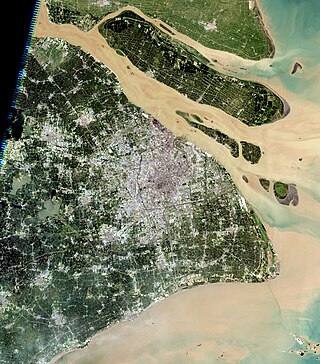
Chongming District is the northernmost district of the provincial-level municipality of Shanghai. Chongming consists of three low-lying inhabited alluvial islands at the mouth of the Yangtze north of the Shanghai peninsula: Chongming, Changxing, and Hengsha. Following its massive expansion in the 20th century, Chongming is now the 2nd-largest island administered by the People's Republic of China, after Hainan. Chongming does not, however, administer all of the island: owing to its continual expansion from sediment deposited by the Yangtze, it has merged with formerly separate islands and now includes Jiangsu province's pene-exclave townships of Haiyong and Qilong. Chongming proper covers an area of 1,411 km2 (545 sq mi) and had a population of 704 000 at the time of the Sixth National Census in 2010.

<span class="mw-page-title-main">Nantong</span> Prefecture-level city in Jiangsu, Peoples Republic of China

Nantong is a prefecture-level city in southeastern Jiangsu province, China. Located on the northern bank of the Yangtze River, near the river mouth. Nantong is a vital river port bordering Yancheng to the north; Taizhou to the west; Suzhou, Wuxi and Shanghai to the south across the river; and the East China Sea to the east. Its population was 7,726,635 as of the 2020 census, 3,766,534 of whom lived in the built-up area made up of three urban districts.

<span class="mw-page-title-main">Chongming Island</span> Northernmost part of Shanghai

Chongming, formerly romanized as Chungming, is an alluvial island at the mouth of the Yangtze River in eastern China covering 1,267 square kilometers (489 sq mi) as of 2010. Together with the islands Changxing and Hengsha, it forms Chongming District, the northernmost area of the provincial-level municipality of Shanghai. At the time of the 2010 Chinese census, its population was 660,000.

<span class="mw-page-title-main">Qidong, Jiangsu</span> County-level city in Jiangsu, Peoples Republic of China

Qidong is a county-level city under the administration of the prefecture-level city of Nantong in southeastern Jiangsu province, China. It is located on the north side of the Yangtze River opposite Shanghai and forms a peninsula jutting out into the East China Sea. It has a population of 1.12 million.

<span class="mw-page-title-main">Taizhou, Jiangsu</span> Prefecture-level city in Jiangsu, Peoples Republic of China

Tàizhōu is a prefecture-level city in central Jiangsu province in eastern China. Taizhou is also a member of the Shanghai metropolitan area.Situated on the north bank of the Yangtze River, it borders Nantong to the east, Yancheng to the north and Yangzhou to the west.

The Chonghai Bridge is a proposed bridge to span the northern distributary at the mouth of the Yangtze River in the People's Republic of China. The bridge, along with the Chongqi Bridge and the Shanghai Yangtze River Tunnel and Bridge, is to connect the city of Shanghai with the north bank of the Yangtze in Jiangsu Province via Chongming Island.

<span class="mw-page-title-main">Haimen, Nantong</span> District in Jiangsu, Peoples Republic of China

Haimen is a district of Nantong, Jiangsu province, with a population of approximately 1 million. It is located at the opposite side of the Yangtze River to Shanghai and is directly north of Chongming Island except for a small portion that forms Haimen District's Haiyong Town. Haimen is the seat of the Roman Catholic Diocese of Haimen. Haimen is located in the poorer north Jiangsu region and together with Qidong City, traditionally has one of the highest rates of liver cancer in China and in the world, with upwards of 1 out of every 10 adults in the rural areas dying from liver cancer.

<span class="mw-page-title-main">Chongming–Qidong Yangtze River Bridge</span> Jiangsu-Shanghai fixed link

Chongming-Qidong Yangtze River Bridge or the Chongqi Bridge, also called Chongqi Crossing Project, is a bridge across the north fork of the Yangtze River, near the river's mouth between Chongming Island of Shanghai and Qidong in Jiangsu Province. This bridge, along with the Shanghai Yangtze River Tunnel and Bridge to the south, forms the last crossing of the Yangtze River before the river empties into the East China Sea. The bridge carries the six-lane G40 Shanghai–Xi'an Expressway, part of the National Expressway Network of the People's Republic of China.

<span class="mw-page-title-main">Shanghai Yangtze River Tunnel and Bridge</span> Fixed link between Chongming Island and Pudong, eastern China

The Shanghai Yangtze River Tunnel and Bridge is a bridge–tunnel complex across the south fork of the Yangtze River near the river mouth in Shanghai. The tunnel connects the Pudong District of Shanghai on the south bank of the river with Changxing Island, while the bridge connects Changxing Island with Chongming Island. In combination with the Chongqi Bridge, which connects Chongming Island to the north bank of the Yangtze, the bridge–tunnel complex forms the final crossing of the Yangtze before it empties into the East China Sea.

<span class="mw-page-title-main">Islands of Shanghai</span> Geographic features in China

The islands of Shanghai are those under the jurisdiction of the Shanghai municipal government. They comprise three large inhabited islands and a shifting number of smaller, uninhabited ones. Most are alluvial islands in the Yangtze River Delta in China, although a number of islands in Hangzhou Bay off Jinshan District are also administered by Shanghai. The alluvial islands are relatively young and their number varies over time. In 2006, the city's 19 uninhabited islands covered 226.27 square kilometers (87.36 sq mi), with a total coastline length of 309 kilometers (192 mi).

<span class="mw-page-title-main">Jiangyin Yangtze River Bridge</span> Bridge in Jiangyin and Jingjiang, Jiangsu

The Jiangyin Yangtze River Bridge is a suspension bridge over the Yangtze River in Jiangsu, China. The bridge has a main span of 1,385 metres (4,544 ft) connects Jiangyin south of the river to Jingjiang to the north. When the bridge was completed in 1999, it was the fourth longest suspension bridge span in the world and the longest in China. Several longer bridges have since been completed in China and abroad, and it is currently the 15th longest suspension bridge in the world. The bridge was also the furthest downstream on the Yangtze until the completion of the Sutong Yangtze River Bridge in 2008 and the Chongming–Qidong Yangtze River Bridge in 2011.

<span class="mw-page-title-main">Yan'an Elevated Road</span> Elevated road in Shanghai, China

Yan'an Elevated Road is an elevated expressway in the city of Shanghai, China. It runs along Yan'an Road in its entirety, continuing from the east terminus of G50 Shanghai-Chongqing Expressway at Huqingping Interchange to just beyond the old building of Shanghai Natural History Museum, at which point it ends and rejoins Yan'an Road on the surface. Traffic is then partly directed underground to the Bund Tunnel. Motorists continuing east can cross the Huangpu River using the East Yan'an Road Tunnel to Pudong.

<span class="mw-page-title-main">G15 Shenyang–Haikou Expressway</span> Motorway in eastern China

The Shenyang–Haikou Expressway, designated as G15 and commonly referred to as the Shenhai Expressway is an expressway in China that connects the cities of Shenyang, Liaoning, and Haikou, Hainan. When fully complete, it will be 3,710 km (2,310 mi) in length. One of its oldest portions is the Shenyang–Dalian Expressway, or Shenda Expressway is a 400 km (250 mi) expressway that connects Shenyang and Dalian, the two largest cities of China's Liaoning province.

<span class="mw-page-title-main">G50 Shanghai–Chongqing Expressway</span> Road in western China

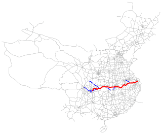
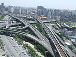
The Shanghai–Chongqing Expressway, designated as G50 and commonly referred to as the Huyu Expressway is an east-west bound expressway that connects the cities of Shanghai, China in Yangtze River Delta, and Chongqing in western China. The expressway runs through six provinces/municipalities and adjoin major cities such as Wuhu, Anqing, Wuhan and Yichang, roughly parallel to G42 Shanghai-Chengdu Expressway to its south. The thoroughfare begins at Huqingping Outer Ring Interchange near Hongqiao International Airport, where it meets S20 Outer Ring Expressway in Shanghai, and terminates at an interchange in Jiangbei District, where the highway joins G75 Lanzhou-Haikou Expressway. It is fully complete and spans 1,900 km (1,200 mi) in length.

Haiyong is a town of Haimen District in Nantong, Jiangsu, China. Together with neighboring Qilong, it forms a pene-enclave of the province on Chongming Island, most of which belongs to the province-level municipality of Shanghai. Haiyong presently covers about 12.5 square kilometers (5 sq mi) and had a population of 5,004 during the year 2000 census.

Yonglongsha, sometimes translated as the Yonglong Shoal or Yonglong Sands, was a former island in the north channel of the Yangtze River to the north of Chongming in eastern China. It was also known as Yongfengsha and Hefengsha. Prior to its absorption by Chongming, it measured about 16 kilometers (9.9 mi) east to west but was very narrow, with an area of about 14 km2 (5.4 sq mi).

Qilong is a township of Qidong in eastern Jiangsu province. The land it occupies was formerly Yonglongsha, a separate island in the Yangtze River delta, but reclamation projects and natural deposition of sediment have joined it to Chongming Island, where it now forms a pene-enclave within Shanghai's Chongming County. Its population was 3436 at the time of the 2010 Chinese census. Qilong's name—literally "opening prosperity"—is a compound of contracted forms of its county and its former island.

The 2015 Tour of Chongming Island World Cup was a one-day road cycling race, run as part of the ninth Tour of Chongming Island, which included both a multi-stage event and a single-stage event. The single-stage race, which was part of the 2015 UCI Women's Road World Cup, was held on 17 May 2015, in Shanghai, China.