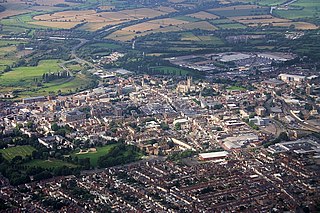
Gloucester is a cathedral city and the county town of Gloucestershire in the South West of England. Gloucester lies on the River Severn, between the Cotswolds to the east and the Forest of Dean to the west, 19 miles (31 km) east of Monmouth and 17 miles (27 km) east of the border with Wales. Including suburban areas, Gloucester has a population of around 150,000. It is a port, linked via the Gloucester and Sharpness Canal to the Severn Estuary.

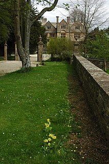
Painswick is a town and civil parish in the Stroud District in Gloucestershire, England. Originally the town grew from the wool trade, but it is now best known for its parish church's yew trees and the local Rococo Garden. The village is mainly constructed of locally quarried Cotswold stone. Many of the buildings feature south-facing attic rooms once used as weavers' workshops.
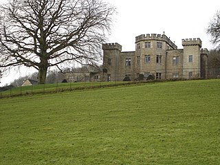
Nether Lypiatt Manor is a compact, neo-Classical manor house in the mainly rural parish of Thrupp, near Stroud in Gloucestershire. It was formerly the country home of Prince and Princess Michael of Kent and is a Grade I listed building.

Lydney Park is a 17th-century country estate surrounding Lydney House, located at Lydney in the Forest of Dean district in Gloucestershire, England. It is known for its gardens and Roman temple complex.

Gloucester Castle was a Norman-era royal castle situated in the city of Gloucester in Gloucestershire, England. It was demolished in 1787 and replaced by Gloucester Prison.
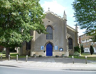
St Mary de Lode Church is a Church of England church immediately outside the grounds of Gloucester Cathedral. It is believed by some to be on the site of the first Christian church in Britain. The church is in the Diocese of Gloucester and Grade I listed by English Heritage. It has also been known as St. Mary Before the Gate of St. Peter, St. Mary Broad Gate and St. Mary De Port.

St Michael's Tower, Gloucester, stands at The Cross, where the four main streets of Gloucester meet. The Cross is also the highest point in the city. The Tower is on the corner of Eastgate and Southgate Streets and the entrance is in Southgate Street. It was built in 1465 on the site of the previous St Michael the Archangel. It is no longer used for religious ceremonies. It became a Grade II* listed building in 1952.

The Westgate area of Gloucester is centred on Westgate Street, one of the four main streets of Gloucester and one of the oldest parts of the city. The population of the Westgate ward in Gloucester was 6,687 at the time of the 2011 Census.
Ablington Manor is a Grade I listed country house in Potlicker's Lane, Ablington within the parish of Bibury, Gloucestershire, England. The estate was owned by the Howse family, until John Coxwell purchased it in 1574. Coxwell built the house in 1590, and alterations and additions were added in around 1780. The house is a Grade I listed building.
Edgeworth Manor is a Grade II* listed country house in Edgeworth, Gloucestershire, England. It was mentioned in the Domesday Book, when it held by Roger de Lacy. The current house is mainly dated to 1685, when the previous Tudor house was replaced for Nathaniel Ridler. It underwent significant changes to south under Capel N. Tripp in 1882 and Sir Ernest George in 1899.
Lasborough Park is a Grade II listed country house in Newington Bagpath/Lasborough, Tetbury, Gloucestershire, England. The estate includes a medieval manor, a house, and parkland. The original medieval manor, Lasborough Farm, dates to the 11th century, and included terraced gardens. A manor house is record in the 14th century. The manor was surrounded by woodland and a deer park. Lasborough House and its pleasure grounds was built in 1794.

There are no records to state that the house was built in the 1200's. It was in fact built in the 1400's.
Nicholas Hyett (1709-1777) was a lawyer and justice of the peace in Gloucester, England, and one of the last keepers and constables of the Castle of Gloucester.

Painswick House is a grade I listed house in Painswick, Gloucestershire, England. It is surrounded by a Grade II* listed rococo garden.

Bearland House is a grade II* listed building in Longsmith Street, Gloucester, England.

66 Westgate Street is a grade II* listed building in Gloucester, UK. It has been listed by Historic England under the Planning Act 1990.

The Fleece Hotel, Westgate Street, Gloucester is a timber framed building dating from the 15th century, which incorporated a 12th-century stone undercroft. The building is part grade I and part grade II listed with Historic England.

High Orchard was an industrial area of the city of Gloucester in England that was developed in the 19th century on the former orchard of the Priory of Llanthony Secunda (1136). The area was closely associated with Gloucester Docks immediately to the north, and served by the Gloucester and Sharpness Canal and railway transport. It was the site of Fielding & Platt's Atlas Works and a number of other significant local employers.

Hempsted Court was a country house at Hempsted near Gloucester in England. It was the home of the Lysons family. It was demolished in 1962 and replaced by a housing estate.
Eastgate Street is one of the ancient streets in Gloucester, so named because its eastern end was originally the location of the east gate in the city's walls. The part beyond the gate as far as GL1 leisure Centre was part of Barton Street It runs from the crossroads of Northgate, Eastgate, Southgate and Westgate Streets in the West to Barton Street in the East.