
Grójec County is a unit of territorial administration and local government (powiat) in Masovian Voivodeship, east-central Poland. It came into being on January 1, 1999, as a result of the Polish local government reforms passed in 1998. Its administrative seat and largest town is Grójec, which lies 40 kilometres (25 mi) south of Warsaw. The county contains three other towns: Warka, 25 km (16 mi) east of Grójec, Nowe Miasto nad Pilicą, 34 km (21 mi) south-west of Grójec, and Mogielnica, 22 km (14 mi) south-west of Grójec.

Biłgoraj County is a unit of territorial administration and local government (powiat) in Lublin Voivodeship, eastern Poland. It was established on January 1, 1999, as a result of the Polish local government reforms passed in 1998. Its administrative seat and largest town is Biłgoraj, which lies 79 kilometres (49 mi) south of the regional capital Lublin. The county contains three other towns: Tarnogród, lying 21 km (13 mi) south of Biłgoraj, Józefów, lying 24 km (15 mi) east of Biłgoraj, and Frampol, 16 km (10 mi) north of Biłgoraj.

Opole Lubelskie County is a unit of territorial administration and local government (powiat) in Lublin Voivodeship, eastern Poland. It was established on January 1, 1999, as a result of the Polish local government reforms passed in 1998. Its administrative seat is the town of Opole Lubelskie, which lies 44 kilometres (27 mi) west of the regional capital Lublin. The only other town in the county is Poniatowa, lying 8 km (5 mi) north-east of Opole Lubelskie.

Mińsk County is a unit of territorial administration and local government (powiat) in Masovian Voivodeship, east-central Poland. It was (re)created on January 1, 1999, as a result of the Polish local government reforms passed in 1998. Its administrative seat and largest town is Mińsk Mazowiecki, which lies 39 kilometres (24 mi) east of Warsaw. The county contains three other towns: Sulejówek, 21 km (13 mi) west of Mińsk Mazowiecki, Halinów, 16 km (10 mi) west of Mińsk Mazowiecki, and Kałuszyn, 17 km (11 mi) east of Mińsk Mazowiecki.

Pruszków County is a unit of territorial administration and local government (powiat) in Masovian Voivodeship, east-central Poland. It came into being on January 1, 1999, as a result of the Polish local government reforms passed in 1998. Its administrative seat and largest town is Pruszków, which lies 15 kilometres (9 mi) west of Warsaw. The county also contains the towns of Piastów, lying 4 km (2 mi) north-east of Pruszków, and Brwinów, 7 km (4 mi) south-west of Pruszków.

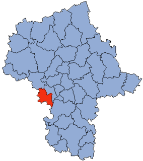
Warsaw West County is a unit of territorial administration and local government (powiat) in Masovian Voivodeship, east-central Poland. It came into being on January 1, 1999, as a result of the Polish local government reforms passed in 1998. In spite of its name, the county does not include any part of the city of Warsaw proper.

Garwolin County is a unit of territorial administration and local government (powiat) in Masovian Voivodeship, east-central Poland. It came into being on 1 January 1999, as a result of the Polish local government reforms passed in 1998. Its administrative seat and largest town is Garwolin, which lies 56 kilometres (35 mi) south-east of Warsaw. The county contains three other towns: Łaskarzew, 13 km (8 mi) south of Garwolin, Pilawa, 10 km (6 mi) north-west of Garwolin, and Żelechów, 22 km (14 mi) south-east of Garwolin.

Maków County is a unit of territorial administration and local government (powiat) in Masovian Voivodeship, east-central Poland. It came into being on January 1, 1999, as a result of the Polish local government reforms passed in 1998. Its administrative seat and largest town is Maków Mazowiecki, which lies 73 kilometres (45 mi) north of Warsaw. The only other town in the county is Różan, lying 20 km (12 mi) east of Maków Mazowiecki.

Węgrów County is a unit of territorial administration and local government (powiat) in Masovian Voivodeship, east-central Poland. It came into being on January 1, 1999, as a result of the Polish local government reforms passed in 1998. Its administrative seat and largest town is Węgrów, which lies 73 kilometres (45 mi) east of Warsaw. The only other town in the county is Łochów, lying 26 km (16 mi) north-west of Węgrów.
Żyrardów County is a unit of territorial administration and local government (powiat) in Masovian Voivodeship, east-central Poland. It came into being on 1 January 1999, as a result of the Polish local government reforms passed in 1998. Its administrative seat and largest town is Żyrardów, which lies 43 kilometres (27 mi) south-west of Warsaw. The only other town in the county is Mszczonów, lying 11 km (7 mi) south-east of Żyrardów.

Grodzisk Mazowiecki County is a unit of territorial administration and local government (powiat) in Masovian Voivodeship, east-central Poland. It came into being on 1 January 1999, as a result of the Polish local government reforms passed in 1998. Its administrative seat and largest town is Grodzisk Mazowiecki, which lies 29 kilometres (18 mi) south-west of Warsaw. The county also contains the towns of Milanówek, lying 2 km (1 mi) north-east of Grodzisk Mazowiecki, and Podkowa Leśna, 8 km (5 mi) east of Grodzisk Mazowiecki.

Piaseczno County is a unit of territorial administration and local government (powiat) in Masovian Voivodeship, east-central Poland. It came into being on January 1, 1999, as a result of the Polish local government reforms passed in 1998. Its administrative seat and largest town is Piaseczno, which lies 17 kilometres (11 mi) south of Warsaw. The county contains three other towns: Konstancin-Jeziorna, 8 km (5 mi) east of Piaseczno, Góra Kalwaria, 18 km (11 mi) south-east of Piaseczno, and Tarczyn, 16 km (10 mi) south-west of Piaseczno.

Przasnysz County is a unit of territorial administration and local government (powiat) in Masovian Voivodeship, east-central Poland. It came into being on January 1, 1999, as a result of the Polish local government reforms passed in 1998. Its administrative seat and largest town is Przasnysz, which lies 90 kilometres (56 mi) north of Warsaw. The only other town in the county is Chorzele, lying 26 km (16 mi) north of Przasnysz. The county covers an area of 1,217.82 square kilometres (470.2 sq mi). As of 2019 its total population is 52,616, out of which the population of Przasnysz is 17,264, that of Chorzele is 3,088, and the rural population is 32,324.

Ostrów Mazowiecka County is a unit of territorial administration and local government (powiat) in Masovian Voivodeship, east-central Poland. It came into being on January 1, 1999, as a result of the Polish local government reforms passed in 1998. Its administrative seat and largest town is Ostrów Mazowiecka, which lies 89 kilometres (55 mi) north-east of Warsaw. The only other town in the county is Brok, lying 12 km (7 mi) south of Ostrów Mazowiecka.

Nowy Dwór Mazowiecki County is a unit of territorial administration and local government (powiat) in Masovian Voivodeship, east-central Poland. It came into being on January 1, 1999, as a result of the Polish local government reforms passed in 1998. Its administrative seat and largest town is Nowy Dwór Mazowiecki, which lies 33 kilometres (21 mi) north-west of Warsaw. The county also contains the towns of Nasielsk, lying 21 km (13 mi) north-east of Nowy Dwór Mazowiecki, and Zakroczym, 5 km (3 mi) west of Nowy Dwór Mazowiecki. Warsaw-Modlin Airport is located within the county. The county covers an area of 691.65 square kilometres (267.0 sq mi). As of 2019, its total population is 79,256, out of which the population of Nowy Dwór Mazowiecki is 28,649, that of Nasielsk is 7,702, that of Zakroczym is 3,196, and the rural population is 39,709.

Białobrzegi County is a unit of territorial administration and local government (powiat) in Masovian Voivodeship, east-central Poland. It came into being on January 1, 1999, as a result of the Polish local government reforms passed in 1998. Its administrative seat and largest town is Białobrzegi, which lies 63 kilometres (39 mi) south of Warsaw. The only other town in the county is Wyśmierzyce, lying 10 km (6 mi) west of Białobrzegi.

Żuromin County is a unit of territorial administration and local government (powiat) in Masovian Voivodeship, east-central Poland. It came into being on January 1, 1999, as a result of the Polish local government reforms passed in 1998. Its administrative seat and largest town is Żuromin, which lies 121 kilometres (75 mi) north-west of Warsaw. Other towns in the county are Bieżuń, lying 13 km (8 mi) south of Żuromin and Lubowidz, lying 9 km (6 mi) north-west of Żuromin.

Ciechanów County is a unit of territorial administration and local government (powiat) in Masovian Voivodeship, east-central Poland. It came into being on January 1, 1999, as a result of the Polish local government reforms passed in 1998. Its administrative seat and largest town is Ciechanów, which lies 77 kilometres (48 mi) north of Warsaw. The only other town in the county is Glinojeck, lying 25 km (16 mi) west of Ciechanów.

Sokołów County is a unit of territorial administration and local government (powiat) in Masovian Voivodeship, east-central Poland. It came into being on January 1, 1999, as a result of the Polish local government reforms passed in 1998. Its administrative seat and largest town is Sokołów Podlaski, which lies 88 kilometres (55 mi) east of Warsaw. The only other town in the county is Kosów Lacki, lying 23 km (14 mi) north of Sokołów Podlaski.
Gmina Konstancin-Jeziorna is an urban-rural gmina in Piaseczno County, Masovian Voivodeship, in east-central Poland. Its seat is the town of Konstancin-Jeziorna, which lies approximately 8 kilometres (5 mi) east of Piaseczno and 17 km (11 mi) south-east of Warsaw.


