The San Francisco Peninsula is a peninsula in the San Francisco Bay Area that separates San Francisco Bay from the Pacific Ocean. On its northern tip is the City and County of San Francisco. Its southern base is Mountain View, south of Palo Alto and north of Sunnyvale and Los Altos. Most of the Peninsula is occupied by San Mateo County, between San Francisco and Santa Clara counties, and including the cities and towns of Atherton, Belmont, Brisbane, Burlingame, Colma, Daly City, East Palo Alto, El Granada, Foster City, Hillsborough, Half Moon Bay, La Honda, Loma Mar, Los Altos, Menlo Park, Millbrae, Pacifica, Palo Alto, Pescadero, Portola Valley, Redwood City, San Bruno, San Carlos, San Mateo, South San Francisco, and Woodside.

Mountain View is a city in Santa Clara County, California, United States. Named for its views of the Santa Cruz Mountains, it has a population of 82,376.

Alviso is a district of San Jose, California, located in North San Jose on the southern shores of San Francisco Bay. Originally an independent town, founded in 1852, today Alviso is San Jose's only waterfront district, primarily residential in nature, with several Silicon Valley tech companies and recreation-oriented businesses. Alviso is named after 19th-century Californio ranchero Ignacio Alviso, who owned the area as part of his Rancho Rincón de Los Esteros.

Alum Rock Park, in the Alum Rock district of San Jose, California, is California's oldest municipal park, established in 1872 but serving as public land since the pueblo was established in 1777. Located in a valley in the Diablo Range foothills on the east side of San Jose, the 720 acre (2.9 km2) park offers 13 miles (21 km) of trails, varying from fairly level along Penitencia Creek to sharp switchbacks climbing to the ridges to the South Rim Trail and the North Rim Trail. The narrow floor of the valley includes a visitor center, a small museum/animal rehab facility, picnic areas, playgrounds, lawns, sand volleyball pits, mineral springs, lush plant life, woodlands, creek play opportunities, and occasional group camping.
The Bay Area Ridge Trail is a planned 550-mile (890 km) multi-use trail along the hill and mountain ridgelines ringing the San Francisco Bay Area, in Northern California. Currently, 400 miles (640 km) have been established. When complete, the trail will connect over 75 parks and open spaces. The trail is being designed to provide access for hikers, runners, mountain bicyclists, and equestrians. It will be accessible through trailheads near major population centers, while the trail will extend into more remote areas. The first trail section was dedicated on May 13, 1989.

Coyote Creek is a river that flows through the Santa Clara Valley in Northern California. Its source is on Mount Sizer, in the mountains east of Morgan Hill. It eventually flows into Anderson Lake in Morgan Hill and then northwards through Coyote Valley to San Jose, where it empties into San Francisco Bay.

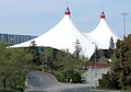
Shoreline Amphitheatre is an outdoor amphitheater located in Mountain View, California, in the San Francisco Bay Area. The venue has a capacity of 22,500, with 6,500 reserved seats and 16,000 general admission on the lawn. When the parking lot is utilized for festival stages, the total capacity of the venue can reach 30,000. The venue has hosted popular music festivals such as Lollapalooza and Ozzfest, and also developer conferences such as the Google I/O.

Don Edwards San Francisco Bay National Wildlife Refuge (DESFBNWR) is a United States National Wildlife Refuge located in the southern part of San Francisco Bay, California. The Refuge headquarters and visitor center is located in the Baylands district of Fremont, next to Coyote Hills Regional Park, in Alameda County. The visitor center is on Marshlands Rd, off Thornton Ave.

Stevens Creek is a creek in Santa Clara County, California. The creek originates in the Santa Cruz Mountains on the western flank of Black Mountain in the Monte Bello Open Space Preserve near the terminus of Page Mill Road at Skyline Boulevard. It flows southeasterly through the Stevens Creek County Park before turning northeast into Stevens Creek Reservoir. It then continues north for 12.5 miles through Cupertino, Los Altos, Sunnyvale and Mountain View before emptying into the San Francisco Bay at the Whisman Slough, near Google's main campus.
Richardson Bay is a shallow, ecologically rich arm of San Francisco Bay, managed under a Joint Powers Agency of four northern California cities. The 911-acre (369 ha) Richardson Bay Sanctuary was acquired in the early 1960s by the National Audubon Society. The bay was named for William A. Richardson, early 19th century sea captain and builder in San Francisco. It contains both Strawberry Spit and Aramburu Island.
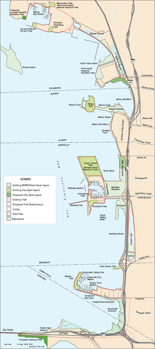
McLaughlin Eastshore State Park is a state park and wildlife refuge along the San Francisco Bay shoreline of the East Bay between the cities of Richmond, Albany, Berkeley, Emeryville, and Oakland. It encompasses remnant natural wetlands, restored wetlands, as well as landfill west of the Eastshore Freeway. Its shoreline is 8.5 miles (13.7 km) long, and its total area is 1,854 acres (750 ha), which includes both tidelands and uplands. Originally named just Eastshore State Park, it was renamed in October 2012 to honor the late Save the Bay founder Sylvia McLaughlin, who, along with the late Dwight Steele of Citizens for Eastshore Park, drove the establishment of the park. Prior to 2013, it was jointly managed by the California State Parks and East Bay Regional Park District (EBRPD). The state agency and EBRPD executed a 30-year agreement for EBRPD to manage the park.
Hoffman Marsh is a wetlands on San Francisco Bay in Richmond, California. The marsh has been protected within Eastshore State Park, and adjacent to Point Isabel Regional Shoreline. The marsh is an important nesting ground for wildfowl and stopping ground on the Pacific Flyway, as it is one of only a handful of undestroyed wetlands in the Bay Area. It borders Point Isabel Regional Shoreline and Interstate 80.
Citizens for East Shore Parks (CESP) is a United States environmental organization that focuses on the acquisition and preservation of parkland in the San Francisco Bay Area. CESP works to protect open space along the East Bay shoreline for natural habitat and recreational purposes through a combination of advocacy, education, and outreach. Since its founding in 1985, CESP has worked to secure approximately 1,800 acres (730 ha) of public land, primarily through the creation of the 8.5-mile (13.7 km) long Eastshore State Park in 2002.
Chelsea Wetlands is a riparian marsh on lower Pinole Creek and a tidal wetland at its mouth on San Pablo Bay, in Contra Costa County, northern California. It is located within the city of Hercules, in the East Bay region of the San Francisco Bay Area.
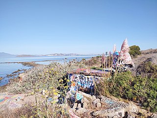
The Albany Bulb is a former landfill largely owned by the City of Albany, in California. The Bulb is the west end of a landfill peninsula jutting west from the east shore of San Francisco Bay. The term "Bulb" is often used to refer to the entire peninsula, which includes the Albany Plateau, north of Buchanan Street at its base; the high narrow "Neck," and the round "Bulb." The Bulb is part of the City of Albany, and can be reached via Buchanan Street or the Bay Trail along the east side of San Francisco Bay.
Permanente Creek is a 13.3-mile-long (21.4 km) stream originating on Black Mountain in Santa Clara County, California, United States. It is the namesake for the Kaiser Permanente health maintenance organization. Named by early Spanish explorers as Arroyo Permanente or Rio Permanente because of its perennial flow, the creek descends the east flank of Black Mountain then courses north through Los Altos and Mountain View, discharging into southwest San Francisco Bay historically at the Mountain View Slough but now partly diverted via the Permanente Creek Diversion Channel to Stevens Creek and the Whisman Slough in San Francisco Bay.

The Bay checkerspot is a butterfly endemic to the San Francisco Bay region of the U.S. state of California. It is a federally threatened species, as a subspecies of Euphydryas editha.

Alamitos Creek or Los Alamitos Creek is a 7.7-mile-long (12.4 km) creek in San Jose, California, which becomes the Guadalupe River when it exits Lake Almaden and joins Guadalupe Creek. Los Alamitos Creek is located in Almaden Valley and originates from the Los Capitancillos Ridge in the Santa Cruz Mountains, near New Almaden. This creek flows through the Valley's Guadalupe Watershed, which is owned by the Santa Clara Valley Water District. The creek flows in a generally northwesterly direction after rounding the Los Capitancillos Ridge and the town of New Almaden, in the southwest corner, before ambling along the Santa Teresa Hills on northeast side of the Almaden Valley. Its environment has some relatively undisturbed areas and considerable lengths of suburban residential character. Originally called Arroyo de los Alamitos, the creek's name is derived from "little poplar", "alamo" being the Spanish word for "poplar" or "cottonwood".

Hooks Island is an uninhabited, approximately 36-acre (15 ha) tidal salt marsh island in San Francisco Bay, in Palo Alto, California, United States. In the 2010s, it was observed to be a home for tens of near-endangered California clapper rails.