Thackley

Last updated

Thackley
Thackley Corner - geograph.org.uk - 24295.jpg
Thackley Corner, Thackley
West Yorkshire UK location map.svg
Red pog.svg
Thackley
Location within West Yorkshire
OS grid reference SE17503870
Metropolitan borough
Metropolitan county
Region
Country England
Sovereign state United Kingdom
Post town BRADFORD
Postcode district BD10
Dialling code 01274
Police West Yorkshire
Fire West Yorkshire
Ambulance Yorkshire
List of places
UK
England
Yorkshire
53°50′38″N1°44′02″W / 53.844°N 1.734°W / 53.844; -1.734 Coordinates: 53°50′38″N1°44′02″W / 53.844°N 1.734°W / 53.844; -1.734

Thackley is a small suburb near Bradford, West Yorkshire in England. The village is loosely bordered by the village of Idle to the south, to the west by the West Royd area of Shipley and elsewhere by the Leeds and Liverpool Canal. Thackley is the northernmost part of Bradford south of the River Aire.

Contents

History

Prehistory

An archaeological project during 2009 funded by the Heritage Lottery Fund, revealed the site in Buck Wood of an enclosure that was in use as a settlement from Neolithic to post-Roman times. [1] [2] The work, undertaken by the Friends of Buck Wood led by a professional archaeologist, showed that in the past a substantial boundary wall had been built of local unworked stone, enclosing a natural terrace of level ground now surrounded by woods. [1] This formed an oval enclosure, roughly 82 m by 78 m in size. The remains of a quern stone for grinding grain was found within this central area, as was a single cup marked carved rock. Leading away from the enclosure is an orthostat wall of large stones, part of a network of such walls in the wood. [1]

Industrial development

Former works premises on Thackley Road Thackley Road - Thackley - geograph.org.uk - 612248.jpg
Former works premises on Thackley Road

Historically the area formed part of the Lordship of Idle. [3] In the 17th century a tanning industry developed and in the 19th century sandstone was quarried, and mills were built for a local cotton industry. [4]

Brackendale Mill was a woollen mill established circa 1800 in the north of Thackley. [5] The mill was extended in 1829 with an engine house and water wheel [6] and in the 1870s a steam powered weaving shed was added to the site. [5] [6] Today the mill building is living accommodation.

Recent dwelling development on Weavers Croft off Crag Hill Road occupies part of the site of the former Bowling Green Mills. [7]

Transport history

Trolley Bus turning at Thackley Corner terminus Bradford Trolleybus turning at Thackley Corner - geograph.org.uk - 1299446.jpg
Trolley Bus turning at Thackley Corner terminus

The  Leeds and Liverpool Canal was built through the far north of Thackley in the 1770s. [8]

In 1845 railway construction began with the building of a two-track Thackley Railway Tunnel under Thackley Hill [7] in use up until 1968. In 1900 a second adjacent and parallel tunnel was added on the northern side of the original to create a fast passenger line and a slow goods line on the Airedale Line.

In 1875, the Great Northern Railway opened its Shipley and Windhill Line, a 6.5 miles (10.5 km) double track branch line from Quarry Gap junction near Laisterdyke to Shipley and Windhill railway station, passing Eccleshill and Idle railway stations and Thackley railway station. [9] Thackley railway station, rebuilt in 1894, is in the middle of Thackley. [9] The line wasn't competitive and after 1931 it was made single line freight only, and progressively closed from 1966 to 1968. [9] [10] The route through Thackley can be easily identified todaythe rails have been removed and the route is overgrown by trees but the cuttings and original railway bridges in Thackley still remain. [7]

A trolleybus service ran from Shipley, West Yorkshire up to its terminus at Thackley Corner in the centre of Thackley. [11]

The Open Air School

Between 1908 and 1939 sickly children from Bradford were bussed in to attend the Open Air School in Buck Wood. [12] Near the main entrance to Buck Wood on Ainsbury Avenue (private road) is a plateau originally formed from waste material created when the first railway tunnel was built under Buck Wood. [12] This flat raised area was used as a playground by children at the school and traces of the foundations of the school buildings can still be seen beyond the steps leading down from the north-east edge of the plateau.[ citation needed ]

Geography

Buck Mill Lane bridge and the Leeds and Liverpool Canal Buck Mill Lane Bridge - geograph.org.uk - 354039.jpg
Buck Mill Lane bridge and the Leeds and Liverpool Canal

The village has no obvious focal centre such as a village green however the road system is centred on a crossroads in the south of the village known as Thackley Corner. From Thackley Corner Town Lane heads south toward Idle and Bradford while Thackley Road runs north into a largely residential area. [13] To the north of the village is the Airedale Railway Line linking Shipley and Leeds. North of the rail line is the Leeds and Liverpool Canal separating Thackley from Baildon and Esholt further north and then the River Aire. [13] To the northwest at the end of Thackley Road is Buck Mill Lane leading down Buck Hill across the canal at Buck Mill Lane Bridge and then across the River Aire at Buck Mill Bridge, a foot and bridle bridge leading to the Charlestown area of Baildon. [13]

To the west of the village is the Burnwells and Thackley End areas of Thackley and to the east Simpson Green. [13]

Buck Wood

The entrance to Buck Wood on Thackley Road Entrance to Buck Wood at Thackley Road - geograph.org.uk - 1569165.jpg
The entrance to Buck Wood on Thackley Road

Buck Wood lies to the north of Thackley. The wood covers an area of fairly level high ground, as well as the steep north-facing slope down to the Leeds and Liverpool canal. Above this valley Buck Wood forms a broad semi-circular zone of woodland, adjoining other similar woods that are part of a woodland corridor stretching along the Aire Valley. Covering 42 hectares, Buck Wood is bordered by the curving route of the canal at its lower perimeter around 60 m above sea-level. Its highest boundary 135 m above sea level, is shaped by the tree-lined sweep of Ainsbury Avenue leading from Thackley through to Esholt. [14] Thackley itself forms the southern boundary of the Wood, and at the northern edge near Dawson Wood is where part of the land is taken up by Yorkshire Water's waste water primary settling tanks. [15]

Buck Wood lies above a layer of millstone grit rock with numerous rocky outcrops, especially on the steeper slopes, where quarrying has taken place. [16] The wood contains a mixture of habitats, with areas of both broad-leaved woodland and mixed deciduous/coniferous plantations. It has patches of marshland created by the many springs occurring throughout the Wood. [17] There are fields scattered within the woodland, some used as pasture for grazing. Buck Wood has a variety of habitats and is an important reservoir for wildlife in Thackley and the surrounding area, and an area for walking and other leisure activities.

Landmarks

Thackley Methodist Church (1889) on Thackley Road Thackley Methodist Church - Thackley Road - geograph.org.uk - 612245.jpg
Thackley Methodist Church (1889) on Thackley Road

Notable buildings include the large Methodist church on Thackley Road and the Methodist Community Hall that serves as a village hall for various groups and societies. [18]

Thackley Tunnel west portal Thackley tunnel West portal - geograph.org.uk - 1439296.jpg
Thackley Tunnel west portal

The village is the site of Thackley Tunnel, one of a pair of long railway tunnels running underneath Thackley Hill and around the north of the village. Idle (L&BR) railway station was a short lived railway station located just to the west of the western entrance to Thackley Tunnel some distance from Idle itself. There are a series of pairs of tunnel ventilation shafts across the landscape between the tunnel portals through the farms in the north of Thackley. [19] No longer used, the (older) southerly tunnel is blocked off midway down its length and the entrance portals gated.

Field Locks on the Leeds and Liverpool Canal near Thackley Field Locks - geograph.org.uk - 30857.jpg
Field Locks on the Leeds and Liverpool Canal near Thackley

The Leeds and Liverpool Canal runs parallel with the course of the River Aire in a distinctive bend around Thackley Hill. A tow path runs along the north side of the canal where the Idle and Thackley Angling Association have fishing rights. [20] [21]

North of Thackley adjacent to Field Wood on the canal is the listed Field Locks (1774–77) a three-rise set of locks. [8] Just west of these locks is a long disused rail bridge part of the Esholt Sewage Works Railway belonging to Yorkshire Water. Further east is a swing bridge and Yorkshire Water's Esholt Waste Water treatment works. [13] On the Thackley side of the canal at this point is Yorkshire Water's storm water tanks and waste water screening plant. Further east and south along the canal is Idle Swing Bridge and Thackley Canal Bridges carrying the Airedale rail line over the canal a short distance east of the eastern portals of Thackley rail tunnels. [13] [20]

In 2006 the area around Thackley Road, Crag Hill Road, and Park Road was surveyed as the area was under consideration for conservation area status - but this was turned down due to the area's mixture of listed buildings with some modern features adjacent to modern buildings. [4] [7]

Listed buildings in Thackley are to be found on Burnwells, Crag Hill Road, Ellar Carr Road, Mitchell Lane, North Street, Park Place, Park Road, Thackley Road, Windhill Old Road, the Leeds and Liverpool Canal and farmhouses in an arc around the north of the village. [8] [22] and as part of the Thackley Urban Village Project a sculpture trail has been created in Buck Wood. [23]

Governance

The village is located in the Idle and Thackley ward, and in the newly revived parliamentary constituency of Bradford East formerly Bradford North. [24]

Economy

Leeds Road near Thackley Corner Leeds Road - Thackley - geograph.org.uk - 1050954.jpg
Leeds Road near Thackley Corner
Low Ash Farm in the north of Thackley village Farm south of The Nosegay, Thackley - geograph.org.uk - 247671.jpg
Low Ash Farm in the north of Thackley village

Thackley Corner and a section of Leeds Road to the west are home to most of the village's shops, pubs and eateries. Amenities include a dry cleaners, [25] butcher, long standing established Estate Agents Martin Lonsdale, newsagent, hair salon, and vape shop. [26]

There are three public houses in Thackley, The Great Northern, The Commercial Inn, and a micropub The Black Rat. [27] Another micropub - The Ainsbury - can be found on the corner of Thackley Road and Crag Hill Road, opposite Thackley Methodist Church.

Many of the properties in the north of the village are historic farm buildings and some have specialised in horse riding.

Education

Thackley Primary School on Thackley Corner Thackley Primary School - Town Lane - geograph.org.uk - 612491.jpg
Thackley Primary School on Thackley Corner

Thackley Primary School is situated on the south east of Thackley Corner, and Immanuel College is located on Leeds Road in the east of the village. [28] [29]

Transport

The nearest  railway station is Shipley, with connections to Bradford, Leeds and Keighley. The main 'A' Road through the village is the A657 Leeds Road running from Shipley in the west to Greengates in the east and onto Leeds. FirstGroup's bus services operate from Shipley through Thackley to Buttershaw (612, 613 & 614) providing a 15-minute frequency into Bradford and Shipley Monday to Saturday daytime.

Keighley Bus Company also provides a half-hourly daytime service to Bingley, Keighley, Leeds and Shipley; this is operated as the Aireline 60, taking its name from the local River Aire. TLC Travel 660 service between Bradford and Shipley also runs on an hourly basis Monday to Saturday daytime. Leeds and Liverpool Canal is used almost entirely by barge pleasure craft.

Sport

The village has a football team, Thackley F.C., who play in the NCEL Premier Division and have their home ground at Dennyfield in Buck Wood to the north-west of the village. [30] The village cricket club, Thackley C.C., play nearby in their ground off Thackley Road. [31]

Culture and events

The Friends of Buck Wood group was established in March 2004; membership consists of local residents and users of the wood. Working in partnership with Bradford Council, the owners of the wood, the group aims to protect and improve Buck Wood for the benefit of the wildlife, environment and the people of the surrounding area.

The 'Friends' organise a variety of events throughout the year aimed at adding to people's enjoyment and understanding of the woodland environment. Members meet regularly for activities such as clearing the Open Air School site, [12] cutting back overgrown bushes, planting native wildflowers and bulbs, and installing bat and bird boxes. Oliver Rhodes, patron of Bradford Grammar School, resides in the Thackley area. His life is celebrated each year at the Thackley Methodist church.

Notable people

Joseph Wright, a distinguished 19th/20th Century professor of linguistics at Oxford University was born in Thackley and grew up in nearby Windhill. [32] He published in 1892 the book A grammar of the dialect of Windhill, which was one of the first attempts to apply phonetics to an English dialect. He later published the English Dialect Dictionary in six volumes.

See also

Related Research Articles

<span class="mw-page-title-main">West Yorkshire</span> County in Yorkshire and the Humber, England

West Yorkshire is a metropolitan and ceremonial county in the Yorkshire and the Humber region of England. It is an inland and upland county having eastward-draining valleys while taking in the moors of the Pennines. West Yorkshire came into existence as a metropolitan county in 1974 after the reorganisation of the Local Government Act 1972 which saw it formed from a large part of the West Riding of Yorkshire. The county had a population of 2.3 million in the 2011 census making it the fourth-largest by population in England. The largest towns are Huddersfield, Castleford, Batley, Bingley, Pontefract, Halifax, Brighouse, Keighley, Pudsey, Morley and Dewsbury. The three cities of West Yorkshire are Bradford, Leeds and Wakefield.

<span class="mw-page-title-main">Esholt</span> Village in West Yorkshire, England

Esholt is a village between Shipley and Guiseley, in the metropolitan district of the City of Bradford, West Yorkshire, England. It is situated 3 miles (4.8 km) east of Shipley town centre, 1.5 miles (2.4 km) south-west of Guiseley Main Street, 7 miles (11 km) north of Bradford City Centre, and 10 miles (16 km) north-west of Millennium Square, Leeds.

<span class="mw-page-title-main">Saltaire</span> Village in West Yorkshire, England

Saltaire is a Victorian model village in Shipley, West Yorkshire, England, on the River Aire by Salt's Mill and the Leeds and Liverpool Canal. It is a UNESCO World Heritage Site and on the European Route of Industrial Heritage.

<span class="mw-page-title-main">Shipley, West Yorkshire</span> Town and civil parish in West Yorkshire, England

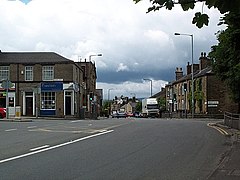
Shipley is a historic market town and civil parish in the City of Bradford, West Yorkshire, England, by the River Aire and the Leeds and Liverpool Canal, north of Bradford. The population of the Shipley ward on Bradford City Council taken at the 2011 Census was 15,483.

<span class="mw-page-title-main">Baildon</span> Town and civil parish in West Yorkshire, England

Baildon is a town and civil parish in the Bradford Metropolitan Borough in West Yorkshire, England and within the historic boundaries of the West Riding of Yorkshire.

<span class="mw-page-title-main">Airedale</span>

Airedale is a geographic area in Yorkshire, England, corresponding to the river valley or dale of the River Aire.

<span class="mw-page-title-main">Wharfedale line</span> Railway line in England

The Wharfedale line is one of the rail services in the West Yorkshire Metro area of northern England. The service connects Ilkley with Leeds and Bradford, and is operated by Northern Trains. West Yorkshire Metrocards are available for use on the line, covering Zones 3–5. The line is served predominantly by four-coach Class 333 electric multiple units.

<span class="mw-page-title-main">Wrose</span> Village and civil parish in West Yorkshire, England

Wrose is a village and civil parish in the City of Bradford metropolitan borough of West Yorkshire, England, about three miles north of Bradford city centre, and south-east of Shipley. The civil parish population taken at the 2011 Census was 7,518.

<span class="mw-page-title-main">Shipley and Windhill railway station</span> Disused railway station in West Yorkshire, England

Shipley and Windhill railway station was a railway station in Shipley, West Yorkshire, England between 1875 and 1931.

<span class="mw-page-title-main">Idle railway station (Leeds and Bradford Railway)</span> Disused railway station in West Yorkshire, England

Idle railway station was a short-lived station serving Idle, near Bradford, West Yorkshire, England.

<span class="mw-page-title-main">Sutton-in-Craven</span> Village and civil parish in North Yorkshire, England

Sutton-in-Craven is a village, electoral ward and a civil parish in the Craven district of North Yorkshire, England that is situated in the Aire Valley between Skipton and Keighley. Historically part of the West Riding of Yorkshire, in 2001 the population was 3,480, increasing to 3,714 at the Census 2011. The village is adjacent to Glusburn and Cross Hills, but although these three effectively form a small town, Sutton village maintains its distinct identity.

<span class="mw-page-title-main">Apperley Bridge</span> Village in West Yorkshire, England

Apperley Bridge is a village in the metropolitan borough of the City of Bradford, in West Yorkshire, England in the Idle and Thackley Ward. Apperley Bridge is north-east of Bradford on the boundary with the City of Leeds bounded in the east by Carr Beck and to the south by Greengates. The village straddles the Leeds and Liverpool Canal and the River Aire. It takes its name from the old bridge over the river on Apperley Lane.

<span class="mw-page-title-main">Idle, West Yorkshire</span> Area of Bradford in west Yorkshire, England

Idle is a residential suburban area in the city of Bradford, West Yorkshire, in England and was a separate village, and before that it was the Manor of Idle. Idle is loosely bordered by the areas of Eccleshill, Wrose, Thackley, Apperley Bridge, and Greengates, in the north-east of the city.

Greengates is a small suburban area in the north-east of the city of Bradford, West Yorkshire, in England. The area is bordered by Idle and Thackley to the north-west, and the large council estate known as Thorpe Edge to the west. To the south of Greengates is Ravenscliffe housing estate with the village of Eccleshill beyond that. The village of Apperley Bridge lies to the north. To the east in the Leeds Metropolitan District is the village of Calverley.

Thackley railway station was a railway station in Thackley, West Yorkshire, England.

Laisterdyke is an area of Bradford, West Yorkshire, England, situated to the east of the city on the border with City of Leeds and located in the Bradford Moor ward and in the Bradford East parliamentary constituency. Laisterdyke borders Barkerend, Bradford Moor area, Thornbury, Tyersal, and Bowling.

<span class="mw-page-title-main">Shipley Great Northern Railway branch line</span> Disused railway line in West Yorkshire, England

The Shipley Great Northern Railway branch line was a railway line that ran east, south and then westwards from Shipley to Bradford in West Yorkshire. The route was opened in 1874 to goods traffic and then to passengers in 1875 by the Great Northern Railway (GNR) and looped around the eastern edge of Bradford. The GNR arrived after other railways had been established in the West Yorkshire area and many of their lines were heavily reliant on tunnels and grand viaducts, the Shipley and Windhill line being an exception to this, although it did have some steep gradients. The branch extended for 8.5 miles (13.7 km) between the two termini of Shipley Windhill and Bradford Exchange. The route as built from Laisterdyke to Shipley was actually only 6.5 miles (10.5 km) as the initial section from Bradford Exchange to Laisterdyke was already in existence as part of the Great Northern Railway's line to Leeds.

<span class="mw-page-title-main">Esholt Sewage Works Railway</span> Former industrial railway in West Yorkshire, England

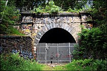
Esholt Sewage Works Railway was a standard gauge works railway constructed in 1910 to serve a sewage works in Esholt, West Yorkshire, England.

<span class="mw-page-title-main">Bradford Beck</span> River in Bradford, West Yorkshire, England

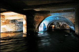
Bradford Beck is a river that flows through Bradford, West Yorkshire, England, and on to the River Aire at Shipley. As it reaches Bradford city centre it runs underground after being built over in the 19th century. It is culverted as it runs from Bradford city centre to Queen's Road after which it runs mostly in an open channel to Shipley. The beck used to be known as the filthiest river in England.

Idle and Thackley is a ward in the metropolitan borough of the City of Bradford, West Yorkshire, England. It contains 131 listed buildings that are recorded in the National Heritage List for England. Of these, two are listed at Grade II*, the middle of the three grades, and the others are at Grade II, the lowest grade. As well as the villages of Idle and Thackley, the ward includes the villages of Apperley Bridge and Greengates, and the surrounding area. The southern part of the ward is mainly residential, and the northern part is mainly rural. Most of the listed buildings are houses, cottages and associated structures, farmhouses and farm buildings. The other listed buildings include public houses, a church, a bridge, an archway to a former burial ground, a former toll house, a pair of locks on the Leeds and Liverpool Canal and an adjacent depot building, a war memorial, and a telephone kiosk.

References

  1. 1 2 3 Alvin, Christine; White, Eileen (2009). "A Breath of Ancient Aire" (PDF). Friends of Buck Wood. Retrieved 19 September 2015.
  2. "Prehistoric enclosure, carved rocks and orthostat wall, Buck Wood". Ancient Monuments. Retrieved 1 November 2020.
  3. "Idle Conservation Area Assessment" (PDF). Bradford Metropolitan District Council website. November 2002. Archived from the original (PDF) on 26 October 2011. Retrieved 9 November 2011.
  4. 1 2 "Thackley - Summary of report on potential conservation area" (PDF). Bradford Metropolitan Council website. June 2006. Retrieved 11 September 2011.
  5. 1 2 "Brackendale Mills". Yorkshire Industrial Heritage. December 2010. Retrieved 1 October 2013.
  6. 1 2 Swale, Swainby R. "Idle Reflections". Thackley Trumpet. Archived from the original on 12 December 2013. Retrieved 1 October 2013.
  7. 1 2 3 4 "Thackley, Bradford Potential Conservation Area Report" (PDF). Bradford Metropolitan Council. May 2006. Archived from the original (PDF) on 27 September 2011. Retrieved 6 September 2011.
  8. 1 2 3 "Leeds and Liverpool Canal, Field 3 Rise Lock". British Listed Buildings. Retrieved 9 September 2011.
  9. 1 2 3 "Shipley Branch (Laisterdyke Shipley) 1874-1964". Lost Railways West Yorkshire.co.uk. Archived from the original on 11 July 2012. Retrieved 11 September 2011.
  10. Armour, Chris. "Thackley Station". Subterranea Britannica. Retrieved 4 March 2010.
  11. Ledgard, R S (2006). Late Turn - Bradford and Trolleybuses. Haworth: Bobtail Press. p. 7. ISBN   0951101358.
  12. 1 2 3 Countryside Agency (2006). "Thackley Open Air School". Archived from the original on 19 March 2012. Retrieved 6 September 2011.
  13. 1 2 3 4 5 6 Leeds & Bradford A-Z (2 ed.). Geographers' A-Z Map Company. 2006.
  14. "BUCK WOOD, BRADFORD Archaeological Survey Report" (PDF). Friends of Buck Wood. March 2006. p. 2. Retrieved 4 April 2016.
  15. "Esholt Waste Water Treatment Works". Morgan Sindall. Archived from the original (PDF) on 24 October 2013. Retrieved 2 October 2011.
  16. Priestley, Mike (9 December 2006). "Buck Wood". Telegraph and Argus. Retrieved 24 March 2016.
  17. Countryside Agency (2006). "Buck Wood Wetland area". Local Heritage Initiative. Archived from the original on 19 March 2012. Retrieved 10 September 2011.
  18. "Thackley Methodist Church & Community Centre". The Bradford North Circuit. Archived from the original on 9 September 2010. Retrieved 6 September 2011.
  19. "Routes and transport shaping Buck Wood". Friends of Buck Wood. Retrieved 4 April 2016.
  20. 1 2 "Thackley - South of Esholt Sewage Works" (PDF). City of Bradford Metropolital District Council. Retrieved 6 September 2011.
  21. "Idle and Thackley Angling Association". Archived from the original on 2 September 2011. Retrieved 6 September 2011.
  22. "1-3"., "4-10"., "12-14, Burnwells"., "11-39, Crag Hill Road"., "1-3"., "Park Ho., Ellar Carr Road"., "Plumpton Ho., Mitchell Lane"., "1-11, North Street"., "1-11, Park Place"., "3-21"., "47-53"., "55-59"., "63-65"., "71-75"., "163-165"., "167-173, Park Road"., "9-11"., "13-17"., "19-21"., "23"., "25-31"., "33, Thackley Road"., "33-39"., "52-54, Windhill Old Road"., "Birk Hill"., "Cote"., "Low Ash"., "North Hall"., "North Street"., "Park Hill"., and "Simpson Green". Farmhouses, British Listed Buildings. Retrieved 3 May 2012.
  23. Walker, Ged (20 July 2011). "Have your say on the Final Stone in the Thackley Sculpture Trail!". Artworks Creative Communities. Retrieved 6 September 2011.; "Buck Wood, Thackley - Sculpture Trail". Flickr. 21 April 2011. Retrieved 6 September 2011.
  24. Bradford Metropolitan District Council (April 2004). "Idle and Thackley" (PDF). Bradford Observatory. Retrieved 11 September 2011.[ permanent dead link ]
  25. "Thackley Dry Cleaners". thackleydrycleaners.com. Archived from the original on 7 January 2014. Retrieved 1 May 2014.
  26. "Ideaz Party Shop". ideaz-uk.com. Retrieved 1 May 2014.
  27. "Pubs in Thackley". Pubs Galore. Retrieved 6 September 2011.
  28. "Thackley Primary School". thackleyschool.com. Retrieved 2 September 2011.
  29. "Welcome to Immanuel College". 2010. Retrieved 6 September 2011.
  30. "Thackley AFC - the Dennyboys". Archived from the original on 10 December 2011. Retrieved 2 September 2011.
  31. "Thackley CC". Play-Cricket. Archived from the original on 15 July 2012. Retrieved 6 September 2011.
  32. Lunnon, Jenny (28 February 2008). "From woollen mills to dreaming spires". Oxford Mail. Retrieved 19 September 2015.