Kangchenjunga, also spelled Kanchenjunga, Kanchanjanghā and Khangchendzonga, is the third-highest mountain in the world. Its summit lies at 8,586 m (28,169 ft) in a section of the Himalayas, the Kangchenjunga Himal, which is bounded in the west by the Tamur River, in the north by the Lhonak River and Jongsang La, and in the east by the Teesta River. It lies in the border region between Nepal and Sikkim state of India, with three of the five peaks, namely Main, Central and South, directly on the border, and the peaks West and Kangbachen in Nepal's Taplejung District.

K2, at 8,611 metres (28,251 ft) above sea level, is the second-highest mountain on Earth, after Mount Everest at 8,849 metres (29,032 ft). It lies in the Karakoram range, partially in the Gilgit-Baltistan region of Pakistan-administered Kashmir and partially in the China-administered Trans-Karakoram Tract in the Taxkorgan Tajik Autonomous County of Xinjiang.

Lhotse is the fourth highest mountain in the world at 8,516 metres (27,940 ft), after Mount Everest, K2, and Kangchenjunga. The main summit is on the border between Tibet Autonomous Region of China and the Khumbu region of Nepal.

Makalu is the fifth highest mountain in the world at 8,485 metres (27,838 ft). It is located in the Mahalangur Himalayas 19 km (12 mi) southeast of Mount Everest, on the China–Nepal border. One of the eight-thousanders, Makalu is an isolated peak in the shape of a four-sided pyramid.

Dhaulagiri, located in Nepal, is the seventh highest mountain in the world at 8,167 metres (26,795 ft) above sea level, and the highest mountain within the borders of a single country. It was first climbed on 13 May 1960 by a Swiss-Austrian-Nepali expedition. Annapurna I is 34 km (21 mi) east of Dhaulagiri. The Kali Gandaki River flows between the two in the Kaligandaki Gorge, said to be the world's deepest. The town of Pokhara is south of the Annapurnas, an important regional center and the gateway for climbers and trekkers visiting both ranges as well as a tourist destination in its own right.

Shishapangma, or Shishasbangma or Xixiabangma, is the 14th-highest mountain in the world, at 8,027 metres (26,335 ft) above sea level. It is located entirely within Tibet. In 1964, it became the final eight-thousander to be climbed.

Rakaposhi also known as Dumani is a mountain within the Karakoram range. It is situated in the middle of the Nagar Valley and the Bagrote Valley, which is part of the Gilgit-Baltistan territory in Pakistan. The mountain is extremely broad, measuring almost 20km from east to west. It is the only peak on earth that descends directly and without interruption for almost 6,000 meters from its summit to its base.

Pumori is a mountain on the Nepal-China border in the Mahalangur section of the Himalayas. Pumori lies just eight kilometres west of Mount Everest. Pumori, meaning "the Mountain Daughter" in Sherpa language, was named by George Mallory. "Pumo" means young girl or daughter and "Ri" means mountain in Sherpa language. Climbers sometimes refer to Pumori as "Everest's Daughter". Mallory also called it Clare Peak, after his daughter.

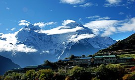
Ama Dablam is a mountain in the eastern Himalayan range of Koshi Province, Nepal. The main peak is 6,812 metres (22,349 ft), the lower western peak is 6,170 metres (20,243 ft). Ama Dablam means "mother's necklace"; the long ridges on each side like the arms of a mother (ama) protecting her child, and the hanging glacier thought of as the dablam, the traditional double-pendant containing pictures of the gods, worn by Sherpa women. For several days, Ama Dablam dominates the eastern sky for anyone trekking to Mount Everest Base Camp. For its soaring ridges and steep faces Ama Dablam is sometimes referred as the "Matterhorn of the Himalayas." The mountain is featured on the one rupee Nepalese banknote.
Peter Boardman was an English mountaineer and author. He is best known for a series of bold and lightweight expeditions to the Himalayas, often in partnership with Joe Tasker, and for his contribution to mountain literature. Boardman and Tasker died on the North East Ridge of Mount Everest in 1982. The Boardman Tasker Prize for Mountain Literature was established in their memory.
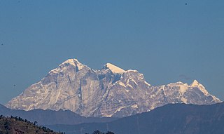
Gaurishankar, a mountain in the Nepal Himalayas, is the second highest peak of the Rolwaling Himal, behind Melungtse (7,181m). The name comes from the Hindu goddess Gauri, a manifestation of Parvati, and her consort Shankar, denoting the sacred regard it is afforded by the people of Nepal. The Sherpas name the mountain as Jomo Tseringma. The Nepal Standard Time (GMT+05:45) is based on the meridian of this mountain peak.

Melungtse is the highest mountain of the Rolwaling Himal in the Himalayas.
Kusum Kanguru is a mountain in the Khumbu Region of the Himalayas in Nepal. Its name, Kusum Kanguru, means "Three Snow-White Gods" in the Sherpa language, which refers to the triple summit of the mountain.

Himalchuli is the second-highest mountain in the Mansiri Himal, part of the Nepalese Himalayas, and the 18th-highest mountain in the world. It lies south of Manaslu, one of the eight-thousanders. Himalchuli has three main peaks: East, West and North.

Cho Polu is a mountain in the Khumbu region of eastern Nepal. Southern neighbors include Num Ri and Baruntse while Imja Tse lies immediately to the west.

Lobuche is a Nepalese mountain which lies close to the Khumbu Glacier and the settlement of Lobuche. There are two main peaks, Lobuche East and Lobuche West. A permit to climb the mountain is required from the Nepal Mountaineering Association (NMA), which classifies Lobuche East (6,119m) as a "trekking peak" and Lobuche West (6,145m) as an "expedition peak". As the easier, trekking peak, the East peak is climbed far more frequently than the West peak; however, most of those climbers only do so to a false summit a few hours from the true summit of Lobuche East. Between the two peaks is a long, deeply notched ridge, though a steep drop and considerable distance makes approaching the West peak from the East impossible.
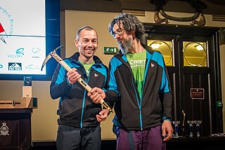
The Piolets d'Or is an annual mountaineering and alpine climbing award organized by the Groupe de Haute Montagne (GHM), and previously with co-founder Montagnes Magazine, since its founding in 1992. Golden ice axes are presented to the annual winners at a weekend awards festival based on their achievements in the previous year. It is considered mountaineering's highest honor and is referred to as the "Oscars of mountaineering".
John Roskelley is an American mountain climber and author. He made first ascents and notable ascents of 7,000-meter and 8,000-meter peaks in Nepal, India, and Pakistan. In 2014, he became the 6th winner of the Piolet d'Or Lifetime Achievement Award.
Pangpoche, also known as Panpoche I is a mountain in the Himalayas of Nepal. It has a summit elevation of 6,620 metres (21,720 ft) above sea level and is located approximately 15 kilometres (9.3 mi) northeast of the world's eighth-highest mountain, Manaslu. On the ridge of Pangpoche to the South in 1.5 kilometers is located Pangpoche II 6,504 meters.